- Hundred of Sydney
Infobox Australian cadastral
name = Hundred of Sydney
state = New South Wales
imagesize = 180px
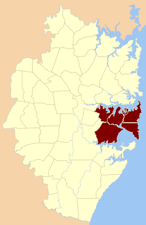
caption = The nine parishes which were part of the Hundred of Sydney
lga =
county = Cumberland
est = 1835
rev = 1888
near-nw = Parramatta
near-n = Packenham
near-ne = "Pacific Ocean "
near-e = "Pacific Ocean "
near-se = "Pacific Ocean "
near-s = Heathcote
near-sw = Liverpool
near-w = ParramattaThe Hundred of Sydney is a former lands administrative division for the city of
Sydney . It was one of the thirteen hundreds in the County of Cumberland, which were published in the government gazette of May 27, 1835, and repealed on January 21, 1888. It included nine parishes (more than any other hundred); the four small parishes in the Sydney city area: St. Andrew, St. James, St. Lawrence and St. Philip, as well as five larger parishes further away from the city: Concord, Petersham, Alexandria, Botany and St. George. Its boundaries were theParramatta River /Sydney Harbour to the north,Botany Bay /Georges River to the south, while the western boundary included part ofHaslams Creek (formerly Hacking Creek) andSalt Pan Creek .The area is part of the modern Local Government Areas of the
Municipality of Woollahra ,Waverley Council ,City of Randwick ,City of Sydney ,City of Botany Bay ,Marrickville Council ,Municipality of Leichhardt ,Municipality of Ashfield ,Burwood Council ,Municipality of Strathfield ,City of Canada Bay , City of Canterbury,City of Hurstville ,Municipality of Kogarah , and theCity of Rockdale .References
* [http://www.bossi.nsw.gov.au/candidate/BOSSI_Parish_Map.pdf The Parish Map] , Board of Surveying and Spatial Information of New South Wales
* [http://nla.gov.au/nla.map-f263 A map of the County of Cumberland in the Colony of New South Wales] , 1840. National Library of Australia MAP F 263.
* [http://nla.gov.au/nla.map-f104 A map of the County of Cumberland in the colony of New South Wales] 1848. National Library of Australia MAP F 104
Wikimedia Foundation. 2010.