- Koyukuk Airport
Infobox Airport
name = Koyukuk Airport
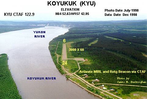
image-width = 250
IATA = KYU
ICAO = PFKU
FAA = KYU
type = Public
owner = State of Alaska DOT&PF - Northern Region
operator =
city-served =Koyukuk, Alaska
location =
elevation-f = 149
elevation-m = 45
coordinates = coord|64|52|33|N|157|43|50|W|region:US_type:airport_scale:10000
website =
r1-number = 6/24
r1-length-f = 4,000
r1-length-m = 1,219
r1-surface = Gravel/Dirt
stat1-header = Enplanements (2007)
stat1-data = 1,018
footnotes = Source:Federal Aviation Administration FAA-airport|ID=KYU|use=PU|own=PU|site=50436.*A, effective 2008-09-25.] [http://www.faa.gov/airports_airtraffic/airports/planning_capacity/passenger_allcargo_stats/passenger/ Preliminary CY 2007 Passenger Boarding and All-Cargo Data] . Federal Aviation Administration. 2008-07-17.]Koyukuk Airport airport codes|KYU [ [http://aviation-safety.net/database/airport/airport.php?id=KYU KYU: Koyukuk Airport, Alaska] . Aviation Safety Network. Retrieved 2008-09-21.] |PFKU [ [http://www.airnav.com/airport/PFKU PFKU: Koyukuk Airport, Alaska] . AirNav.com. Retrieved 2008-09-21.] |KYU is a state-owned public-use
airport located in Koyukuk, a city in the Yukon-Koyukuk Census Area of theU.S. state ofAlaska .As per
Federal Aviation Administration records, this airport had 1,018 passenger boardings (enplanements) incalendar year 2007, a decrease of 22% from the 1,305 enplanements in 2006.Facilities
Koyukuk Airport covers an area of 287
acre s (116 ha) at anelevation of 149 feet (45 m) abovemean sea level . It has onerunway (6/24) with agravel and dirt surface measuring 4,000 x 75 ft (1,219 x 23 m). The runway was extended and widened from its former size of 3,000 by 60 feet.Airlines and non-stop destinations
*
Frontier Flying Service (Galena) [ [http://www.frontierflying.com/timetable-ffs.pdf Frontier Flying Service: 2007 Timetable] (PDF ). Retrieved 31-Aug-2007.]*
Warbelow's Air Ventures (Galena, Nulato) [ [http://www.farecompare.com/flights/Warbelow's_Air_Ventures_Inc.-4W/Koyukuk-KYU/airlinenonstop.html FareCompare: Warbelow's Air Ventures non stop direct flights departing Koyukuk Airport (KYU)] . Retrieved 31-Aug-2007.]*
Wright Air Service (Huslia) [ [http://www.farecompare.com/flights/Wright_Air_Service,_Inc.-8V/Koyukuk-KYU/airlinenonstop.html FareCompare: Wright Air Service non stop direct flights departing Koyukuk Airport (KYU)] . Retrieved 31-Aug-2007.]References
External links
* [http://www.alaska.faa.gov/fai/images/ARPT_DIAGRAMS/KYU.gifFAA Alaska airport diagram] (
GIF )
*
*
Wikimedia Foundation. 2010.