- Drin River
Geobox|River
name = Drin
native_name =
other_name = Drini
category =
etymology =
nickname =
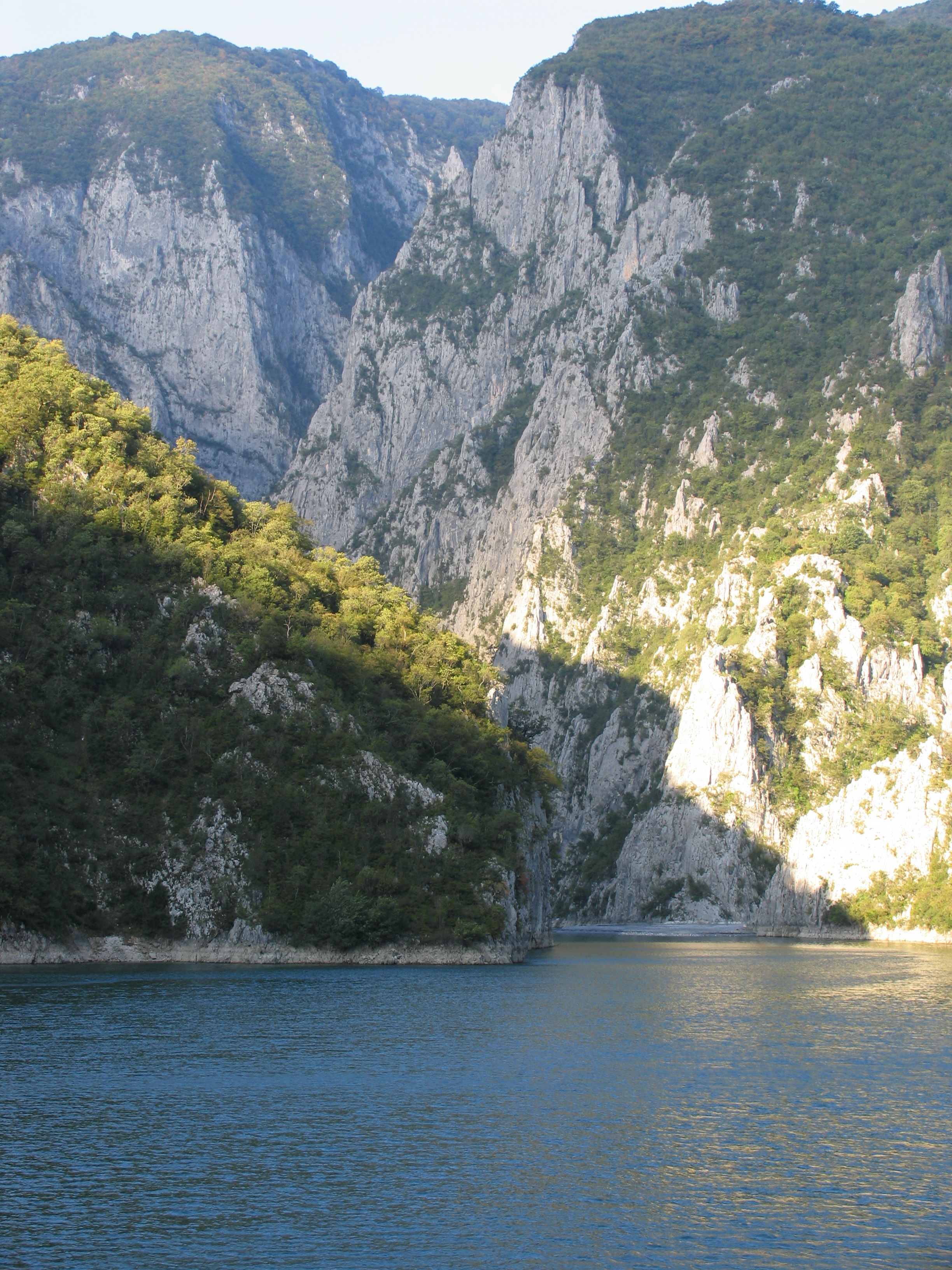
image_caption = Artificial "Lake Koman" filling up the canyons of the Drin in Northern Albania.
country = Albania
state =
region =
district =
municipality =
parent =
tributary_left =
tributary_right =
city =
landmark =
source = confluence ofWhite Drin andBlack Drin
source_location =Kukës | source_region = | source_country =
source_elevation =
source_lat_d = 42| source_lat_m = 04| source_lat_s = | source_lat_NS = N
source_long_d =20 | source_long_m =25 | source_long_s = | source_long_EW =E
source1 =
source1_location = | source1_region = | source1_country =
source1_elevation =
source1_lat_d = | source1_lat_m = | source1_lat_s = | source1_lat_NS =
source1_long_d = | source1_long_m = | source1_long_s = | source1_long_EW =
source_confluence =
source_confluence_location = | source_confluence_region = | source_confluence_country =
source_confluence_elevation =
source_confluence_lat_d = | source_confluence_lat_m = | source_confluence_lat_s = | source_confluence_lat_NS =
source_confluence_long_d = | source_confluence_long_m = | source_confluence_long_s = | source_confluence_long_EW =
mouth = Adriatic Sea
mouth_location = | mouth_region = | mouth_country =
mouth_elevation =
mouth_lat_d = 41| mouth_lat_m =38 | mouth_lat_s = | mouth_lat_NS =N
mouth_long_d = 19| mouth_long_m = 34| mouth_long_s = | mouth_long_EW =E
length = 160
width =
depth =
volume =
watershed =
discharge =
discharge_max =
discharge_min =
free = | free_type =
map_caption = Drin is located in northern Albania
map_background =
map_locator =
map_locator_x =
map_locator_y =
website =
footnotes =The Drini (Дрим, Drim on
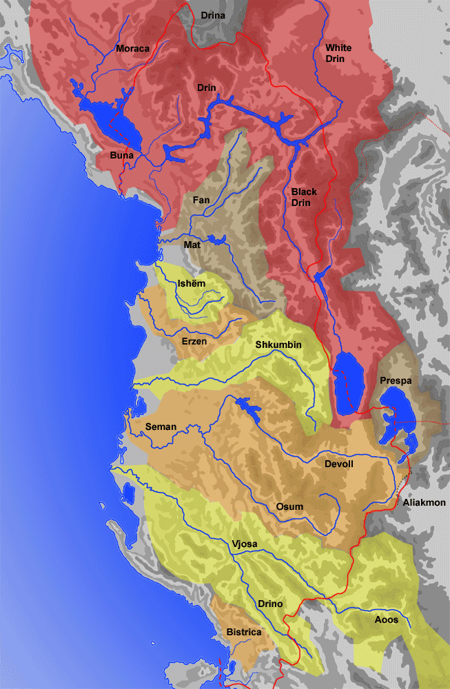
Macedonian , Dhrinos, Δρινος in Greek andAncient greek ) is the longestriver inAlbania with a total length of 160 km. It has twoconfluence s, one into theAdriatic Sea , the other one into theBojana River ("Buna" in Albanian).Origin
The Drin starts at the confluence of its two headwaters, the
Black Drin andWhite Drin , in the city ofKukës in theTrektan area of eastern Albania. Measured from there until its end at the Adriatic sea, the Drin is 160 km long. However, measured from the source of White Drin, its length is 335 km, making it the longest river that runs through Albania. The Black Drin ("Crn Drim" in Macedonian, "Drini i Zi" in Albanian) originates from theLake Ohrid and runs through theRepublic of Macedonia and Albania. The White Drin ("Drini i Bardhë" in Albanian) originates from theRadavc mountain, north of the town ofPeć ,Kosovo , and runs from there through to Albania.Course
From Kukës, the Drin flows through northern Albania, first flowing through the Has area to the north, passing through the towns of Spas, Msi and Fierzë, and then, upon reaching the
Dukagjini area, it descends to the south, flowing through Apripë e Gurit, Toplanë, Dushman, Koman, Vjerdhë and Pale Lalej. AtVau i Dejës , it enters the low Shkodra Field and splits into two arms. One empties into the Bay of Drin (Albanian: "Pellg i Drinit") into theAdriatic Sea southwest of the city ofLezhë (The Mouth of Drin, Albanian: "Gryk'e Drinit"). The other empties into theBojana River near Rozafa. Even though being a shorter branch by 15 km, the section that reaches the Bojana is called Great Drin ("Drini i Madh" in Albanian), because it brings much more water than the longer branch which reaches the sea. The Great Drin also once reached the sea but a major flood in1858 cut it short from the sea, and breached through to the Bojana. The Great Drin is very wide and brings a huge amount of water (320 m³/s), but being short, some maps indicate it as a lake. After Vau i Dejës, the longer branch continues to the south, passing throughBushat , Mabë, Gajdër, Lezhë and Medes. South ofLezha it enters the low and flooded littoral area and flowing through the marshes it finally reaches the Adriatic.Economy
The Drin is extremely important for the Albanian economy, especially for its electricity production. Three dams are built over its cascades producing most of Albania's electricity. The artificial
Lake Fierza (Albanian: "Liqeni i Fierzës") created by the dam at Fierzë is the largest artificial lake in Albania with its surface of 73 km². The second largest lake is also built on this river.Lake Vau i Dejës ("Liqeni i Vau te Dejës" in Albanian) has an area of 25 km². Construction of Fierza power station caused some controversy in the 1980s. Without reaching any agreement, the Albanian government ordered the reservoir to be filled with water, which in the end flooded some border areas of Kosovo, then part of Yugoslavia. The Yugoslav government protested, but no solution was agreed on. Thus, today, Lake Fierza is shared by Albania and Kosovo.Wildlife
The Drin and its surrounding mountainous areas have a great variety of flora and fauna. Recently many fish species have been introduced such as the
zander of northern Europe which is a predator of the native fish population.References
* "Mala Prosvetina Enciklopedija", Third edition (1985); Prosveta; ISBN 86-07-00001-2
* Jovan Đ. Marković (1990): "Enckiklopedijski geografski leksikon Jugoslavije"; Svjetlost-Sarajevo; ISBN 86-01-02651-6See also
*
White Drin
*Black Drin
*Bojana River
Wikimedia Foundation. 2010.