- Indiana State Road 213
Infobox road
state=IN
type=IN
route=213
alternate_name=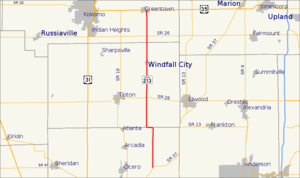
maint=INDOT
length_mi=25
length_round=2
length_ref= [http://www.illi-indi.com/EndsPage.php?id=1213§ion=1 Indiana Highway Ends - SR 213] ]
established=
direction_a=South
starting_terminus=
junction=
direction_b=North
ending_terminus=
counties=Hamilton, Tipton, Howard
cities=
previous_type=IN
previous_route=212
next_type=IN
next_route=218State Road 213 in the
U.S. State ofIndiana is a short north-southstate highway in the eastern portion of Indiana. Its southern terminus is near Noblesville at State Road 37, and its northern terminus isU.S. Route 35 at Greentown.This was also previously used for the State Road 114 - Wabash Road segment of the State Road 13 bypass around North Manchester in the 1940s.
Major intersections
Source: INDOT Roadway Referencing System [ [http://www.in.gov/indot/3361.htm INDOT Roadway Referencing System] ] INint
county=Hamilton
mile=0.00
road=
location=Hamilton County
notes=SR 213 beginsINint
county=Tipton
mile=11.70
road=
location=Tipton CountyINint
county=Howard
cspan=2
mile=21.03
road=
location=Howard CountyINint
mile=24.96
road=
location=Greentown
notes=SR 213 endsReferences

Wikimedia Foundation. 2010.