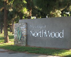
- Northwood, Irvine, California
-
Northwood is a community encompassing the northern portions of the city of Irvine, in Orange County, California. It covers the area enclosed by the Santa Ana Freeway, Culver Drive, Portola Parkway and Jeffrey Road [1].
Contents
History
Northwood, which was developed in the early 1970s, is the only community in Irvine that was developed independent of the Irvine Company. Therefore, it's the only community that is not completely governed by any homeowners' association. Neighborhoods like Park Paseo, Park Place, and Woodside do have homeowners' associations, as well as community pools and jacuzzis. Park Place and Park Paseo share a clubhouse as well.
The area that is now Northwood started off as part of the Irvine Ranch. The Irvine family gave or sold parcels of the area as bonuses and gifts to ranch foremen and other employees. Some 23 chunks of land were held by different owners, who were organized by a single developer who named the area Northwood.
Another community called Northwood Pointe was developed in the 90s by The Irvine Company as a companion neighborhood to Northwood.[1]
Like most of Irvine's villages, Northwood is known for certain unique characteristics, the most prominent of which are the eucalyptus windrows that enclose neighborhoods and line main thoroughfares, and include many of the trees that were planted when the land was farmed, as crop protection against fierce Santa Ana Winds. Also characteristic of the village are views of the Santa Ana Mountains to the north and a preponderance of single-family dwellings often situated on somewhat larger lots. The "Northwood Loop" pre-dates the "Yale Loop" in the village of Woodbridge and serves as a two-lane neighborhood road through the older part of Northwood, with four segments Northwood, Southwood, Eastwood, and Westwood, bisected North-South and East-West by Yale and Bryan Avenues, respectively.
Demographics
Census Information Single females 17.6% Single males 12.8% Median age (years) 40 Average household size 2.861 Homes with kids 34.6% Median household income $86,510 Total households 2,016 Total owners 90.9% Total population 5,768 Total renters 9.1% Longtime homeowners (over 10 yrs) 62.6% Longtime renters (over 10 yrs) 1.7% Recent homeowners (10 yrs or less) 28.4% Recent renters (10 yrs or less) 7.4% Age Distribution Age Range Percentage 0-9 10.3% 10-19 16.6% 20-29 8.2% 30-39 10.0% 40-49 18.8% 50-59 14.3% 60-69 21.7% Parks
Following are the parks located in the community of Northwood
- Brywood Park
- Blue Gum Park
- Carrotwood Park
- Coralwood Park
- Northwood Community Park
- Pepperwood Park
- Pinewood Park
- Sycamore Park
- Silkwood Park
- Medowood Park
- Settlers Park
Because the schools in Irvine are not gated Elementary Schools serve as parks for neighborhoods as well.
Education
Northwood is within the Irvine Unified School District. All four of the elementary schools in Northwood, Santiago Hills Elementary School, Canyon View Elementary School, Brywood Elementary School, and Northwood Elementary School perform well. The elementary schools scored between 889 and 951 out of a possible 1,000 on the 2007 Academic Performance Index Base Report. Northwood Elementary was named a National Blue Ribbon School for 2008.
Sierra Vista Middle School serves as the Middle School in Northwood. It scored 922 in the 2007 Academic Performance Index Base Report.
Northwood High School was included in Newsweek's list of top high schools and has won several Grammy Signature awards, including the Gold School Award. Most students living north of Trabuco Road and west of Jeffrey Road attend Northwood High School, which scored 863.[1]
Shopping Center
The following shopping centers are located in the community:
References
- ^ a b Bonker, Dawn (2008-08-30). "'Sense of community' in Irvine". Los Angeles Times. http://www.latimes.com/news/education/la-hm-guide30-2008aug30,0,1785578.story. Retrieved 2008-09-02.
Villages of Irvine Village Name College Park · Deerfield · El Camino Real · Irvine Spectrum · Laguna Altura · Northpark/Northpark Square · Northwood · Oak Creek · Orchard Hills · Portola Springs · Quail Hill · The Ranch · Rancho San Joaquin · Shady Canyon · Stonegate · Turtle Ridge · Turtle Rock · University Hills · University Park · University Town Center · Walnut · West Irvine · Westpark · Woodbridge · Woodbury · Woodbury East ·
Coordinates: 33°42′45″N 117°45′24″W / 33.7126°N 117.7567°WCategories:- Villages of Irvine, California
Wikimedia Foundation. 2010.

