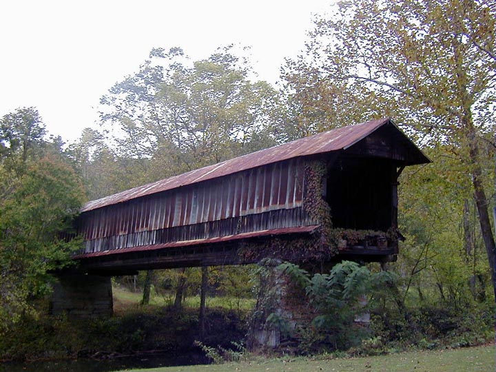
- Waldo Covered Bridge
Infobox Bridge
bridge_name=Waldo CB
caption=The Waldo Covered Bridge near Talladega, Alabama.
official_name=
carries=bridge inaccessible
crosses=Talladega Creek
locale=Waldo, Alabama
maint=PRIVATE USE
id=01-61-02 (WGCB)
design=Howe truss and Queen-post truss combination
mainspan=
length=115 ft (35 m)
width=
height=
load=
clearance=
below=
traffic=
begin=
complete=1858
open=
closed=
toll=
map_cue=
map_
map_text=
map_width=
coordinates= coord|33|22|44.78|N|86|01|43.87|W|region:US_type:landmark|display=inline,title
lat=
long=The Waldo Covered Bridge, also known as the Riddle Mill Covered Bridge, is a privately owned wood & metal combination style
covered bridge that spansTalladega Creek inTalladega County, Alabama ,United States . It is located off State Route 77 just south of the town of Waldo, about 6 miles (10 kilometers) southeast ofTalladega . Coordinates are coor dms|33|22|44.78|N|86|01|43.87|W|city (33.379106, -86.028853).Built in 1858, the 115-foot (35 m) bridge is a combination of
Howe truss and Queen-post truss construction over a single span. Its WGCB number is 01-61-02. The Waldo Covered Bridge is one of five existing covered bridges in Alabama built before 1950 not listed on theNational Register of Historic Places and the only one left unmaintained. It is the second oldest surviving covered bridge in the state.History
The Waldo Covered Bridge was built on an old
Socopatoy Indian trail behind Riddle's Mill, a grist mill which was later converted into the Waldo Town Hall and then a restaurant. Nearby is the Riddle's Hole gold mine, which operated from 1840 throughWorld War II . The bridge was used as an access route in April 1865 byWilson's Raid ers during theAmerican Civil War , acavalry group led byUnion Army General James H. Wilson . The bridge was open to traffic in later years, possibly for mine access during its operation, but condemned by the state in the 1960s and the approaches removed as overall maintenance remained minimal. Even though there was extensive restoration work done to the Waldo Covered Bridge in recent years as part of establishing a recreational park, the project was soon scrapped. As a result, the structure was left to sit on its two stone piers "as is." The Waldo Covered Bridge is currently inaccessible to the public but people can walk the grounds with permission from the Old Mill Restaurant. There were plans by the owners to once again restore the bridge, but time and money have been major issues.References
* Dale J. Travis Covered Bridges. [http://www.dalejtravis.com/bridge/alabama/htm/0106102.htm Waldo CB: Credits] . Retrieved Aug. 14, 2007.
* Bridges to the Past: Alabama's Covered Bridges. [http://www.alabamatv.org/bridges/photos.htm Waldo CB: Credits] . Retrieved Aug. 14, 2007.
* Alabama Bureau of Tourism & Travel. [http://www.800alabama.com/ Waldo CB: Credits] . Retrieved Aug. 14, 2007.
* "The Decatur Daily". [http://www.decaturdaily.com/decaturdaily/news/061101/covered.shtml Waldo CB: Credits] . Retrieved Aug. 14, 2007.
* Alabamiana: A Guide to Alabama. [http://www.al.com/alabamiana/index.ssf?bridges.html Waldo CB: Credits] . Retrieved Aug. 14, 2007.
* Daily Home Online. [http://www.dailyhome.com/news/2005/dh-localnews-1002-snewton-5j01v0206.htm Waldo CB: Credits] . Retrieved Aug. 14, 2007.
* Alabama Historical Commission (1969). "Alabama's Covered Bridges". Retrieved Oct. 27, 2007.
* Alabama Department of Archives and History. [http://216.226.178.196/index.php Waldo CB: Credits] . Retrieved Oct. 27, 2007.ee also
*
List of Alabama covered bridges External links
* [http://www.alabamatv.org/bridges/photos.htm Bridges to the Past: Alabama's Covered Bridges]
* [http://www.dalejtravis.com/bridge/alabama/htm/0106102.htm Waldo Covered Bridge (Dale J. Travis)]
Wikimedia Foundation. 2010.
