Nijinomatsubara

Nijinomatsubara
Nijinomatsubara
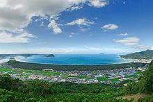
Fisheye view of Nijinomatsubara

Nijinomatsubara (虹の松原 nijinomatsubara?) is a 360 year old pine forest in Karatsu, Saga. It has a width of 400 - 700 metres, a length of about 4 km, and a total area of 240 hectares. It was also referred as The Black Pine Forest of 1 Million Trees (100万本のクロマツを中心とした松林 hyaku man hon no kuromatsu wo chuushin toshita matsubayashi?), however this name is uncommon today.

The forest was originally planted by the feudal lord Terasawa as a counter-measure against the strong winds and tides in Karatsu Bay. Today it is a popular tourist spot, and on a list of the 100 most beautiful places in Japan.

This forest is easily accessible from both Karatsu City and Fukuoka City, by the Chikuhi Subway Line. As well, there are several hotels and places to park nearby.

See also

  • List of Special Places of Scenic Beauty, Special Historic Sites and Special Natural Monuments

External links

Coordinates: 33°26′48″N 130°01′42″E / 33.446643°N 130.028322°E / 33.446643; 130.028322


Wikimedia Foundation. 2010.

Игры ⚽ Нужно решить контрольную?

Look at other dictionaries:

  • Nijinomatsubara Station — 虹ノ松原駅 Station building Location Prefecture …   Wikipedia

  • Karatsu — 33°27′N 129°58′E / 33.45, 129.967 Karatsu shi (唐津市) …   Wikipédia en Français

  • Saga Prefecture — Infobox Prefecture Japan Name = Saga JapaneseName = 佐賀県 Rōmaji = Saga ken Symbol = PrefSymbol Saga.png Capital = Saga Region = Kyūshū Island = Kyūshū TotalArea = 2,439.58 AreaRank = 42nd PCWater = 1.7 PopDate = February 1 2008 Population =… …   Wikipedia

  • Karatsu, Saga — Infobox City Japan Name= Karatsu JapaneseName= 唐津市 Map Region= Kyūshū Prefecture= Saga District= Area km2= 487.42 PopDate= September 1, 2007 Population= 129,329 Density km2= 265 Coords= LatitudeDegrees= 33 LatitudeMinutes= 27 LatitudeSeconds=… …   Wikipedia

  • Hamatama, Saga — nihongo|Hamatama|浜玉町|Hamatama chō was a town located in Higashimatsuura District, Saga, Japan until it merged on January 1, 2005 to become a part of the city of Karatsu.As of 2003, the town had an estimated population of 10,311 and a density of… …   Wikipedia

  • Chikuhi Line — Map of Japan with the Chikuhi Line highlighted in red …   Wikipedia

  • Meinohama Station — 姪浜駅 South Exit Location Prefecture Fukuoka …   Wikipedia

  • Chikuhi-Linie — ein Zug der Chikuhi Linie Streckenlänge: 68,3 km …   Deutsch Wikipedia

  • Karatsu Royal Hotel Karatsu (Karatsu) — Karatsu Royal Hotel Karatsu country: Japan, city: Karatsu (City) Karatsu Royal Hotel Karatsu Location Karatsu Royal Hotel Karatsu is located in the northern part of Kyushu Island, at the Coast of Genkainada Sea. It takes 3 minutes by taxi from… …   International hotels

  • Chikuzen-Fukae Station — 筑前深江駅 Location Prefecture Fukuoka (See other stations in Fu …   Wikipedia

Share the article and excerpts

Direct link
Do a right-click on the link above
and select “Copy Link”