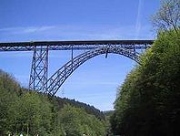
- Müngsten Bridge
-
Müngsten Bridge is the highest steel railroad bridge in Germany. The bridge is 107 metres (351 ft) high and spans the valley of the river Wupper, connecting the cities of Remscheid and Solingen. This stretch is part of the Wuppertal-Oberbarmen–Solingen railway. It is used exclusively by the Regionalbahn service Der Müngstener (RB 47).
Originally the bridge was named Kaiser-Wilhelm-Brücke (Emperor Wilhelm Bridge) to honour Emperor Wilhelm I. After the end of the monarchy the bridge was re-named after the nearby settlement of Müngsten, which is close to the city limits of Solingen, Remscheid and Wuppertal. Today, the settlement no longer exists, so Müngsten is simply a landmark.
Contents
History
First drafts for a bridge connecting the two cities of Remscheid and Solingen go back as far as 1889. Preparatory work began in 1893, the bridge was finished in 1897.
The six support columns have a maximum height of 69 meters (230 ft). In the middle of the structure, the main arc has a span of 170 meters (560 ft). The overall length of the structure is 465 meters (1,530 ft).
A total of 5,000 tons (4,900 LT; 5,500 ST) of steel were used in its construction. 950,000 rivets hold the structure together. During construction, a number of advanced building techniques were used.
Anton von Rieppel (1852 – 31 January 1926), an architect and engineer, was in charge of the project. A memorial plaque at the foot of the bridge reminds one of his efforts.
Originally, the bridge was planned to be single-track. However, high future traffic growth projections led to the redesign as a dual-track bridge. Before its opening, the rail distance between the cities of Remscheid and Solingen was 42 kilometers (26 mi). With a direct connection via the bridge, this distance shrank to 8 kilometers (5.0 mi).
The Prussian Parliament approved the 5 million Marks required to build the bridge in 1890.
The first breaking of the earth was on 26 February 1894. A total of 1,400 kilograms (3,100 lb) of dynamite and 1,600 kilograms (3,500 lb) of black-powder were needed during construction.
The bridge's official inauguration celebration took place on 15 July 1897. Emperor Wilhelm II did not attend the ceremony in person. Prince Friedrich Leopold of Prussia attended the festivities instead. Emperor Wilhelm II visited the bridge two years later, on 12 August 1899.
Myths, legends and anecdotes
The bridge was a masterpiece of Victorian-era engineering. For its time, it was a highly sophisticated structure. It astonished the local population, many of whom had had little exposure to such state-of-the-art engineering work.
Very quickly, urban legends began to spread.
Some of these unfounded “tall tales”, (which are sometimes repeated to this day), are:
- Allegedly, the last rivet fastened in the bridge was made of pure gold.
- Allegedly, due to computational errors made by von Rieppel, the architect, half of the bridge had to be demolished since the two simultaneously built halves did not fit together.
- Allegedly, von Rieppel threw himself off the bridge and died in the fall.
Of course, there is no truth in any of these stories. The bridge was constructed as planned; von Rieppel’s complex calculations, (all carried out without the aid of computers or arithmetic aids), were correct – he died about 30 years later after an unrelated illness.
What might be true are rumours about Emperor Wilhelm II's boycott of the inauguration ceremony. According to legend, the Emperor was annoyed that such a state-of-art structure was named after his grandfather, Wilhelm I, not after himself. He therefore decided not to attend the celebrations in person.
What is true is that the bridge has attracted an unknown, but large number of suicides during its more than 100-year existence.
References
- Pottgießer, Hans (1985). Eisenbahnbrücken aus zwei Jahrhunderten [Railway Bridges from Two Centuries]. Basel, Boston, Stuttgart: Birkhäuser. pp. 255–258. ISBN 3764316772. (German)
External links
- Müngstener Talbrücke at Brueckenweb (German)
- Müngsten Viaduct at Structurae
- Müngstener Brücke Homepage (German)
Coordinates: 51°09′38″N 7°08′00″E / 51.16056°N 7.1333333°E
Wikimedia Foundation. 2010.


