- Eighteenmile Island
Infobox Islands
name = Eighteenmile Island
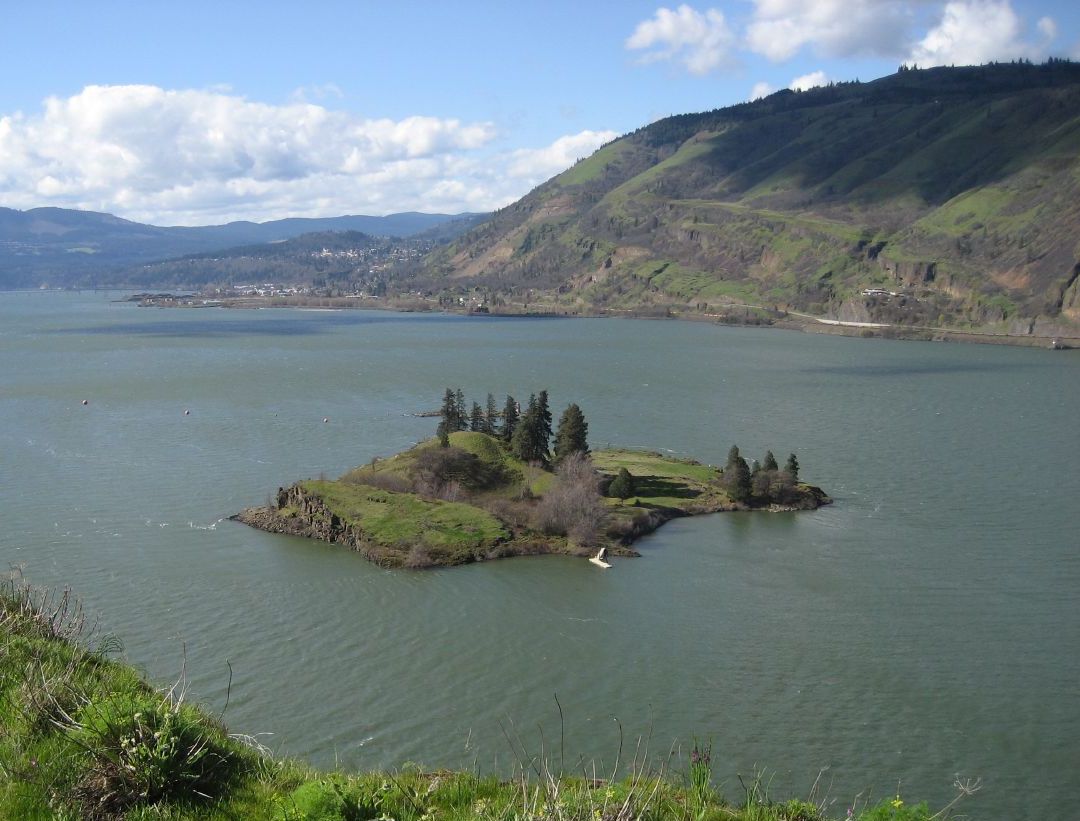
image caption = Eighteenmile Island from an observation point on the Oregon side
locator
native name =
native name link =
location =Mosier, Oregon
coordinates = coord|45|41|23|N|121|25|17|W|display=inline,title
archipelago =
total islands =
major islands =
area = 9.89acre s (4 ha)
highest mount =
elevation =
country = Oregon
country admin divisions title = County
country admin divisions = Wasco County
country 1 admin divisions title = County
country 1 admin divisions = Wasco CountyEighteenmile Island is a 9.89 acre (4 ha) island on the
Oregon side of theColumbia River atriver mile 174 inWasco County, Oregon ,United States . It is about a half mile (0.8 km) downstream ofMosier, Oregon and four miles (6.4 km) upstream ofHood River . It can be seen from Interstate 84, which runs along the Oregon side of the Columbia River, and from theHistoric Columbia River Highway . A small rocky "island" downstream of Eighteenmile Island houses a navigational light. The island is mentioned in the journal ofMeriwether Lewis , from theLewis and Clark Expedition .cite web|url=http://iinet.com/~englishriver/LewisClarkColumbiaRiver/Regions/Places/eighteenmile_island.html|title=Lewis & Clark's Columbia River "200 Years Later" - Eighteenmile Island|accessdate=2007-08-06|publisher=English River Website|author=Topinka, Lyn]Geography
The small island is located in the
Columbia River Gorge region. It was mostly barren as of 2007, but features severaldouglas fir s andwillow s, abasalt cliff, wildflowers and a sandy beach.cite news|title=Forest Service considers buying island in Columbia|publisher="The Oregonian "|date=2000-04-28|author=Senior, Jeanie|url=http://www.oregonlive.com/printer/printer.ssf?/printer/printer.ssf?/news/oregonian/00/04/nw_61islan28.frame] It is closer to the Oregon side of the river, and only a few hundred feet from its shoreline.The island's only structure is a private residence, a three-story wood-frame house built in 1969. A line from the mainland supplies electricity to the island; drinking water must be filtered from the Columbia. The island can only be accessed by boat.
History
During the 20th century it was popularly called "Chicken Charlie's Island", after Charles Reither, who lived on the island from 1915 until his death in 1963. There were not actually chickens on the island during Reither's residency, but there may have been a chicken ranch there around 1904. [cite web|url=http://www.a2zgorge.info/community/towns/mosier.htm|title=Mosier, Oregon information|accessdate=2007-08-06|publisher=A2Zgorge.info] A 1919 tax survey indicates a "George W. Reither", Charles' brother, lived on the island as well. Reither was given title to the island in 1922 from the
Bureau of Land Management . It was officially referred to as "Eighteenmile Island" by theUnited States Geological Survey as early as 1934. It is still referred to as "Chicken Charlie's Island" on some maps. [cite paper|title=Columbia River Gorge Bike Map|accessdate=2007-08-06| url=http://www.skamania.com/pdf/biking-guide.pdf|publisher=Oregon Hotels]Ownership
Eighteenmile Island is the only remaining privately owned island on the Columbia River. Zoning prohibits further development on the island beyond the one existing house. In 2000 when the island was offered for sale, local and federal officials considered buying it to protect it, but deemed that unnecessary as the strict zoning would prevent unwanted development anyway.
The island and house were offered for sale again for $1.4 million in 2007. [ cite web|url=http://www.equitygroup.com/listings/detail.php?lid=15738992&limit=0&offset=0&&&posc=1&post=1&cfq=radarea%3D0%26startnewsearch%3D1%26temp%3D92%26searchtypesent%3D5%26searchtype%3D5%26state%3D41%26mlsids%255B%255D%3D7001615%26SRSearchDate%3D1186452198%26SRRecordCount%3D1%26SRPage%3D1%26SRPageCount%3D1%26SRPageLinks%3D6|title=Listing page|publisher=RE/MAX Oregon|accessdate=2007-08-06]
References
Wikimedia Foundation. 2010.