Ballyroan

Ballyroan

Infobox Irish Place
name = Ballyroan
gaeilge = Baile Átha an Róine
crest

motto =
map

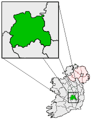
pin coords = left: 57px; top: 55px
north coord = 52.57
west coord = 7.18
irish grid = S464889
province = Leinster
county = County Laois
town pop = ...
rural pop = 1,000
census yr = 2006
web =
|

Ballyroan ( _ga. Baile Átha an Róine) is a small village in County Laois, Ireland, on the R425 regional road. It is part of the parish of Abbeyleix. It has two churches (one of which is Roman Catholic and the other Church of Ireland), two schools (a boys school and girls school), three pubs (Whelan's, Delaney's & Scully's) and two shops.

Ballyroan is a rural village with 1,000 people living in 270 houses. It was developed by the Normans in the 1200s and is situated eight miles from Portlaoise.Fact|date=December 2007

History

There was a Druids Altar in "Cashel". St. Faolan founded a church in Cashel in 468, and between that time and the ninth century, seven bishops are said to have been interred in Tullore, an ancient cemetery, one of the oldest in Ireland. Fact|date=December 2007

The Motte was built by the Normans towards the end of the 12th century. Conall O’Moore built a castle in the 14th century, where Nolan’s house stands today and in the stagecoach days the castle was an inn known as The Bull’s Head. Fact|date=December 2007

The Brigidine Sisters came to the village in 1877. Three sisters from the Abbeyleix Community took up residence in their newly built convent on September 25, that year. Their convent and school closed in 1974 drawing the final curtain as it appeared then on Brigidine residency in Ballyroan, but not on their involvement with education.

port

Ballyroan is well known for its local Gaelic football club, Ballyroan Abbey GAA. A former club was Ballyroan GAA.

ee also

List of towns in the Republic of Ireland


Wikimedia Foundation. 2010.

Игры ⚽ Поможем сделать НИР

Look at other dictionaries:

  • Ballyroan, County Dublin — Ballyroan (irish place name|Baile Ruain) is a locality in Rathfarnham, South Dublin.It is a suburban area at the foot of the Dublin mountains alongside Ballyboden and Knocklyon.Situated around the church and the shopping centre (including the… …   Wikipedia

  • Ballyroan Abbey GAA — Infobox GAA club club gaa = Ballyroan Abbey crest = irish = Beal Atha an Roine Mainistir county = Laois nickname = colours = Sky Blue and Navy grounds = founded = 2007 honours = pattern la = | pattern b=|pattern ra= leftarm= 87ceeb |body=87ceeb… …   Wikipedia

  • Ballyroan GAA — Infobox GAA club club gaa = Ballyroan crest = irish = Beal Atha an Roine county = Laois nickname = The Village colours = Sky Blue and Navy grounds = founded = 1887 honours = pattern la = | pattern b=|pattern ra= leftarm= 87ceeb |body=87ceeb… …   Wikipedia

  • Ballyroan Stakes — The Ballyroan Stakes is a Group 3 flat horse race in the Republic of Ireland open to thoroughbreds which are three years old or above. It is run over a distance of 1 mile and 4 furlongs (2,414 metres) at Leopardstown Racecourse, and it takes… …   Wikipedia

  • Баллирон (Дублин) — Не следует путать с Баллирон. Баллирон (ирл. Baile Uí Ruáin, англ. Ballyroan[1])  пригород Дублина, находящийся в Ратфарнеме (Ирландия). Он расположен у подножия гор Дублина, рядом с Баллибоденом, Баттерфилдом, Ноклайном, Старым… …   Википедия

  • Padraig McMahon — Infobox GAA player | name =Padraig McMahon irish =Padraig MacMathúna placeofbirth=Portlaoise countryofbirth=Ireland dob= dod= nickname= height= sport=Gaelic football code=Football county=Laois province=Leinster clposition=Midfield club=Ballyroan… …   Wikipedia

  • Michael Tierney (Gaelic football) — Infobox GAA player | name =Michael John Tierney irish =Micheál Seán Ó Tiarnaigh placeofbirth= countryofbirth=Ireland dob=14/11/1986 dod= nickname=MJ height=5 11 sport=Gaelic football code=Football county=Laois province=Leinster clposition=Centre… …   Wikipedia

  • Michael Tierney (Gaelic footballer) — Michael John Tierney Personal information Irish name Micheál Seán Ó Tiarnaigh Sport Gaelic Football …   Wikipedia

  • Rathfarnham — Ráth Fearnáin   Suburb of Dublin   …   Wikipedia

  • Ballyboden — Infobox Irish Place name = Ballyboden gaeilge = Baile Buadáin crest motto = map pin coords = left: 45px; top: 103px north coord = 53.282| west coord = 6.29 | irish grid = O144289 area = | elevation = 54 m province = Leinster county = County… …   Wikipedia

Share the article and excerpts

Direct link
Do a right-click on the link above
and select “Copy Link”