Mor Stein

Mor Stein
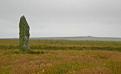
The Mor Stein, standing stone

Mor Stein is a neolithic standing stone in the southeastern part of the island of Shapinsay, Orkney Islands, Scotland. [1] Shapinsay is one of the two large inner islands of the Orkney group, and it is situated approximately two miles north of the Orkney Mainland.[2] Linton Bay is situated slightly to the northeast of Mor Stein.

Mor Stein is a vertical standing stone of approximately 3.2 metres (10 ft) in height, which is unshaped and uncarved and stands in a field somewhat separate from any other man-made features of the island.[3] A few miles to the north is Burroughston Broch with its earth cladding intact, allowing visitors to peer down into the broch from above.[4]

See also

References

  1. ^ United Kingdom Ordnance Survey Map Landranger Map, Orkney Mainland, 1:50,000 scale, 2002
  2. ^ J. Gunn, Orkney, the Magnetic North, Thomas Nelson and Sons, Edinburgh (1932)
  3. ^ C.M Hogan, Natural History of the Orkney Islands, Aberdeen (2006)
  4. ^ Burroughston Broch on line profile

Coordinates: 59°2′12″N 2°49′47″W / 59.03667°N 2.82972°W / 59.03667; -2.82972


Wikimedia Foundation. 2010.

Игры ⚽ Нужен реферат?

Look at other dictionaries:

  • STEIN, ELIEZER LIPMAN — (c. 1778–1851), Hungarian talmudist and preacher. Stein corresponded on halakhah with moses sofer (Responsa Ḥatam Sofer, pt. 6, no. 48), with meir eisenstadt and with his teacher Judah Aszo, author of the responsa Mahari Aszo. Stein served as av… …   Encyclopedia of Judaism

  • Orcadas prehistóricas — Skara Brae, en las Orcadas, es la población neolítica europea mejor conservada del norte de Europa, encontrada hasta …   Wikipedia Español

  • Marmorstein — Mạr|mor|stein, der: behauener Stein aus Marmor …   Universal-Lexikon

  • Maeshowe — Entrance Maeshowe (or Maes Howe) ( …   Wikipedia

  • Rousay — Location …   Wikipedia

  • Mine Howe — is a prehistoric subterranean man made chamber dug 20 feet deep inside a large mound. It is located in the Tankerness area of Orkney, about 5 miles (8 km) southeast of Kirkwall, the capital of Orkney. The origin of the howe (from Old Norse… …   Wikipedia

  • Dwarfie Stane — The Dwarfie Stane with the entrance to the tomb …   Wikipedia

  • The Ouse — is a tidal estuary in northern Shapinsay, Orkney Islands. (Ordnance, 2002) This water body has been shown on early maps of the island in a very similar shape to its current geometry.(Masters, 1840) The Ouse is fed by small rivulets and upland… …   Wikipedia

  • Castle Bloody — is a prehistoric feature on the island of Shapinsay, Orkney, Scotland. Hogan observes that while the feature is marked as a chambered mound [United Kingdom Ordnance Survey Map Landranger Map, Orkney Mainland, 1:50,000 scale, 2002] on the UK… …   Wikipedia

  • Linton Chapel — is a ruined chapel on the east coast of Shapinsay, Orkney Islands (Grid Reference HY5218). [United Kingdom Ordnance Survey Map Landranger Map, Orkney Mainland, 1:50,000 scale (2002)] The chapel is thought to date as early as the 12th century AD.… …   Wikipedia

Share the article and excerpts

Direct link
Do a right-click on the link above
and select “Copy Link”