Colfiorito

Colfiorito
Colfiorito
—  Frazione  —
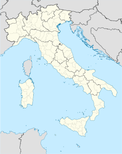
Colfiorito is located in Italy
Colfiorito
Location of Colfiorito in Italy
Coordinates: 43°01′35″N 12°53′24″E / 43.02639°N 12.89°E / 43.02639; 12.89Coordinates: 43°01′35″N 12°53′24″E / 43.02639°N 12.89°E / 43.02639; 12.89
Country  Italy
Region Umbria
Province Perugia
Comune Foligno
Elevation 760 m (2,493 ft)
Population (2001) approx.
 - Total 5,000
Demonym
Time zone CET (UTC+1)
 - Summer (DST) CEST (UTC+2)
Postal code

Colfiorito is a village in Umbria, central Italy, a frazione of the comune of Foligno.

Contents

Geography

It is located on a plateau at 760 m over the sea level, on the road from Foligno to Macerata, which houses a total of c. 5,000 inhabitants (part of it is under the jurisdiction of Serravalle di Chienti, Marche).

History

In the plateau tombs from the 10th century BC and a Iron Age village (9th century BC) have been found. In 178 BC existed here the Roman city of Plestia, which had a forum, a temple and other edifices. In the 5th century AD it had a bishop of its own. The town was abandoned in the 10th century: the site is now marked by the church of Santa Maria in Plestia. The area was repopulated by the comune of Foligno, who built here the castle (1269) from which originated the modern village.

Colfiorito was heavily damaged by the earthquake which rocked Umbria and Marche on September 26, 1997.

Main sights

  • Church of Santa Maria in Plestia (5th century - see description here).
  • Castle of Colfiorito.
  • Castelliere of Monte Orve.
  • Archaeological Museum of the Umbri Plestini

Notes and references


Wikimedia Foundation. 2010.

Игры ⚽ Поможем написать курсовую

Look at other dictionaries:

  • COLFIORITO —    An upland plateau in the Apennines in eastern Umbria, comprising hill forts, sanctuary, and cemetery. The cemetery of some 250 inhumations over an area of 12 hectares at the foot of Monte Orve dates from circa 900 BC to the end of the third… …   Historical Dictionary of the Etruscans

  • Parc naturel régional du Colfiorito — La lagune Catégorie UICN IV (aire de gestion des habitats/espèces) Identifiant 83521 …   Wikipédia en Français

  • B&B Villa Colfiorito — (Галлиполи,Италия) Категория отеля: Адрес: SP 282 N°98 Km 1,9, 73014 Галлиполи, Ит …   Каталог отелей

  • Tenuta Colfiorito — (Castel Madama,Италия) Категория отеля: Адрес: Via Sant Anna, 00024 Castel Madama …   Каталог отелей

  • Lieta Sosta — (Colfiorito,Италия) Категория отеля: 3 звездочный отель Адрес: Via Adriatica 230 Frazione Colfior …   Каталог отелей

  • Plestia — Ancienne illustration des territoires de Plestia[1] Plestia a été une ville ombrienne de la Regio VI Umbria, située sur le plateau de Colfiorito dans la zone de l actuelle église Santa Maria di Pistia, sur les rives du « Lacus Plestinus… …   Wikipédia en Français

  • Hotel Benessere Villa Fiorita — (Colfiorito,Италия) Категория отеля: 3 звездочный отель Адрес: Via Del …   Каталог отелей

  • Relais Forti — (Colfiorito,Италия) Категория отеля: 3 звездочный отель Адрес: Via Adriatica 9, 06034 Colfiorito …   Каталог отелей

  • Casa Religiosa Di Ospitalità — (Colfiorito,Италия) Категория отеля: Адрес: Via Pietro Onori 31, 06034 …   Каталог отелей

  • Foligno — Infobox CityIT img coa = Foligno Stemma.png official name = Comune di Foligno name=Foligno|mapx=42.9|mapy=12.69 region = Umbria province = Perugia (PG) elevation m = 234 area total km2 = 263 population as of = january 1, 2005 population total =… …   Wikipedia

Share the article and excerpts

Direct link
Do a right-click on the link above
and select “Copy Link”