- James River Bridge
Infobox_Bridge
bridge_name=James River Bridge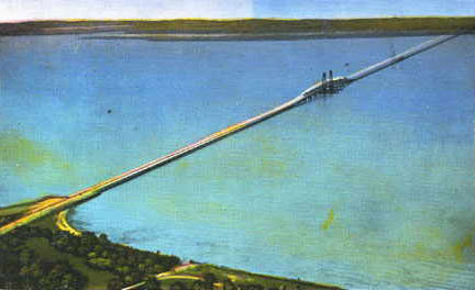
caption=The 1928 bridge, replaced from 1975 to 1982
carries=4 lanes of US 17/258/SR 32
crosses=James River
locale=Isle of Wight County, VA to Newport News, VA
maint=Virginia DOT
id=10364National Bridge Inventory Data, December 2003]
coordinates=coord|37.003|N|76.469|W
open=1982 [ [http://www.virginiadot.org/bulletin/2006SpecialEdition/ferry.asp VDOT Bulletin, May-June 2006, Bridges, Tunnels and Ferries] ]
below=44.1 m (145 ft) open
18.2 m (59.7 ft) closed
design=steel lift bridge
mainspan=126.5 m (415.0 ft)
length=7.0714 km (4.3940 mi)
width=20.8 m (68.2 ft)
clearance=4.87 m (16.0 ft)
map_
map_width=251pxThe James River Bridge is a four-lanedivided highway lift bridge across the James River in theU.S. state ofVirginia . Owned and operated by theVirginia Department of Transportation , it carries U.S. Route 17, U.S. Route 258, and State Route 32 across the river near its mouth atHampton Roads . The bridge connects Newport News on theVirginia Peninsula with Isle of Wight County in theSouth Hampton Roads region, and is the easternmost such crossing without atunnel component.When completed in 1928, the 4.5-mile (7 km) bridge was the longest bridge in the world over water.Fact|date=February 2007 The original two-lane bridge was replaced from 1975 to 1982 with a wider four-lane bridge that could handle increased traffic volumes. In 2005, the bridge carried an
annual average daily traffic of about 30,000 vehicles per day.PDFlink| [http://www.virginiadot.org/info/resources/AADT_046_IsleofWight_2005.pdf 2005 Virginia Department of Transportation Jurisdiction Report - Daily Traffic Volume Estimates - Isle of Wight County] |219 KiB ]Description of the current bridge
At the Newport News end, traffic approaches the bridge at a six-ramp
partial cloverleaf interchange, whereMercury Boulevard (carrying U.S. Route 17, U.S. Route 258, and State Route 32 onto the bridge) passes over Warwick Boulevard (U.S. Route 60). After an intersection with River Road and the entrance to Huntington Park, the four-lane divided bridge begins, lying to the southeast of the part of the old bridge that remains as afishing pier . The 126.5 m (415.0 ft) lift span over the shipping channel, with a clearance of 44.1 m (145 ft) when raised and 18.2 m (59.7 ft) when lowered, is about 1/4 of the way along the 7.0714 km (4.3940 mi) bridge. This allows ocean-going ships to pass en route to civilian port facilities in Hopewell and at thePort of Richmond .The roadway becomes Carrollton Boulevard on the Isle of Wight County end; after a number of intersections, US 258 and SR 32 turn west at Bartlett towards State Route 10 at Benns Church, while US 17 curves southeast towards Portsmouth.
The nearest upstream crossing of the James River is the
Jamestown Ferry (State Route 31); the next fixed crossing is the 1966Benjamin Harrison Bridge (State Route 156) at Hopewell. When the bridge opened in 1928, the next bridge upstream was the 1913Mayo Bridge in Richmond.Downstream, both crossings of
Hampton Roads arebridge-tunnel s for military reasons: the 1992Monitor-Merrimac Bridge-Tunnel (Interstate 664) and 1957Hampton Roads Bridge-Tunnel (Interstate 64/U.S. Route 60).Bicycle s,moped s, andpedestrian s are banned from using the bridge; the easternmost crossing for them is theJamestown Ferry , about 25 miles upstream. [ [http://www.virginiadot.org/programs/bk-info.asp VDOT Info & Service: Bicycling and Walking in Virginia] ] The State Highway and Transportation Commission banned these transportation modes from using the bridge in 1978 "in the interest of safety", due to high traffic and lack ofsidewalk s. [CTB minutes|09-1978-01, page 23] Once the replacement bridge was completed, they returned to the question in 1983, and decided to continue the ban, since the new bridge also had no sidewalks or sufficientrecovery area . [CTB minutes|03-1983-01, page 21]History: longest bridge in the world over water
The private James River Bridge Corporation was chartered by the General Assembly to build a system of bridges across the James River,
Chuckatuck Creek , andNansemond River , as well as approach roads. [CTB minutes|04-1927-02, page 2] On the Newport News end, the bridge simply ended at an intersection with State Route 39/U.S. Route 60 (Virginia Avenue, now Warwick Boulevard). [http://lvaimage.lib.va.us/cgi-bin/vhip_subjects/vhip.pl?&] , late 1920s] However, a large system of approach roads, including two smaller toll bridges, was built on the Isle of Wight County side. Traffic coming off the bridge reached a
Y intersection at Bartlett, at which it could head west over a private approach road past Carrollton to State Route 10 at Benns Church, or head southeast into Nansemond County. The first of the two smaller bridges was theCrittenden Bridge overChuckatuck Creek (the county line) at Crittenden, and the second, after passing the road to Hobson and Chuckatuck (now State Route 628), was theNansemond River Bridge over theNansemond River . The end of the private approach road was at the current intersection of Bennetts Pasture Road (State Route 627) and Lee Farm Lane (State Route 701), where one could go south to State Route 10 (now State Route 337) at Driver. [http://lvaimage.lib.va.us/cgi-bin/vhip_subjects/vhip.pl?&] , revised July 1, 1936] [http://lvaimage.lib.va.us/cgi-bin/vhip_subjects/vhip.pl?&
] , revised July 1, 1936] So the James River Bridge System served not only traffic crossing the James River, but also traffic along State Route 10; the 1928 Chuckatuck-Driver
Kings Highway Bridge (now State Route 125) competed with the James River Bridge System for this traffic.The $5.2 million James River Bridge was opened on
November 17 ,1928 by the press of a button inWashington, D.C. , where U.S. PresidentCalvin Coolidge , sitting in theOval Office of theWhite House , sent an electric signal to lower into place the upraised lift span over the James River channel. [Hampton Roads Daily Press, [http://web.archive.org/web/20010617185024/http://hrticket.com/top/1,1419,N-HRTicket-History-X!ArticleDetail-6569,00.html The crossing of the James River] ] Drivers could now choose to cross Hampton Roads on a fixed bridge rather than one of many ferries. The new bridge was narrow by current standards, with a 20-foot roadway from curb to curb, and railings much less substantial than found on modern structures.Fact|date=February 2007 The main lift span was 300 feet (90 m) long; the other two bridges included 110-foot (34 m) bascule spans. [CTB minutes|10-1954-02, page 184] When completed, it was the longest bridge in the world over water.Fact|date=February 2007From 1928 to 1931, State Route 503, a
state highway from Portsmouth via Churchland and Belleville to the private approach road south of the Nansemond River, was added to the state highway system. [CTB minutes|08-1928-02, page 32] [CTB minutes|08-1929-01, page 17] [CTB minutes|12-1930-02, page 14] U.S. Route 17 was moved onto this alignment (from one of the ferries) by 1932, and still uses it today. [ [http://www.vahighways.com/route-log/us017.htm Virginia Highways Project: US 17] ] State Route 258, now part of U.S. Route 258, was extended over the Benns Church approach and bridge by late 1943 to reach the newMercury Boulevard . [CTB minutes|11-1943-01, page 5] Thus all approaches had numbers at the time of the state takeover in 1949. In 1951, State Route 32 was extended from Suffolk over the bridge to end in Newport News, completely overlapped with other routes, "to facilitate the routing of traffic over the James River Bridge System, between points north of Newport News and south of Suffolk". [CTB minutes|02-1951-01, page 19]Controversial tolls, ownership, shunpiking
As early as 1933, the State Highway Commission (SHC) considered taking over the bridge approaches - but not the bridges themselves - from the corporation. [CTB minutes|03-1933-01, page 17] Projected traffic volumes were not reached, leading to
bankruptcy of the James River Bridge Corporation. It was bought bybondholder s, headed by a local businessman from Smithfield. The new owners raised tolls, proving unpopular with local residents.Lon Wagner, [http://72.14.209.104/search?q=cache:upZhIjDyUbMJ:home.hamptonroads.com/stories/print.cfm%3Fstory%3D71958%26ran%3D179592&hl=en&lr=&strip=1 Groups driven to save James River toll plaza] ,The Virginian-Pilot ,June 20 ,2004 ] Chapter 399 of the Acts of Virginia of 1940 authorized the SHC to acquire the James River Bridge System, consisting of the three bridges and approach roads. The SHC bought the system from the corporation for $5.6 million [CTB minutes|09-1949-01, pages 4 and 6] onSeptember 30 ,1949 .CTB minutes|10-1954-02, pages 143, 172, and 173]However, in 1955, the state doubled tolls to $1.80 round trip for cars and $4.00 or more for trucks, in order to pay for repairs, new toll booths, and a new
punch card system compatible with theHampton Roads Bridge-Tunnel . The toll plazas, which had numbered three - one for each bridge - were consolidated to two, one at the south end of the main bridge and one at the north end of theNansemond River Bridge . Thus theCrittenden Bridge became free for local traffic. In addition, passenger vehicles andlight truck s only had to pay at the first booth they reached; large trucks and buses had to pay twice. This meant that light vehicles crossing only the main bridge (for instance between Smithfield and Newport News) only had to pay southbound.J.W. Luter, Jr. of the localSmithfield Packing Company rerouted his trucks via a smaller, cheaper bridge owned by a Norfolk car dealer. Tolls were eventually dropped to 10 cents per axle, and later removed onJune 3 ,1976 ; the state paid off the remaining bonds at that time. Simultaneously, the parallelHampton Roads Bridge-Tunnel opened, and tolls were removed from that facility, theColeman Bridge , and theRobert O. Norris Bridge . [CTB minutes|05-1976-01, page 28] Many considered this an important step in the development of the area.PDFlink| [http://www.virginiadot.org/about/resources/historyofrds.pdf A History of Roads in Virginia] |4.76 MiB ] The former toll building and parking area was used for maintenance workers, police, and tow truck drivers until 2002, whenasbestos was discovered. Despite the efforts ofpreservationist s, who argued the building had historic significance, it was torn down in 2004.Fact|date=February 2007Replacement bridge without tolls: 1975-1982
A new four-lane lift bridge was completed in stages from 1975 to 1982 at a cost of $75 million. The replacement was funded with
road user tax es rather thantoll revenue bond s.Fact|date=February 2007 When the new bridge was completed, a short section of the old bridge on the Newport News side was retained for use as a fishing pier.References
External links
* [http://www.roadstothefuture.com/US17_JRB.html Roads to the Future: James River Bridge (US-17)]
* [http://www.virginiadot.org/comtravel/hro-tunnel-default.asp VDOT Travel Center: Hampton Roads Tunnels and Bridges]Crossings navbox
structure = Crossings
place = James River
bridge = James River Bridge
bridge signs =
upstream =Jamestown Ferry
upstream signs =
downstream =Monitor-Merrimac Bridge-Tunnel
downstream signs =

Wikimedia Foundation. 2010.