- Gurúè
Infobox Settlement
official_name = Gurúè
other_name =
native_name =
nickname =
motto =
imagesize = 380px
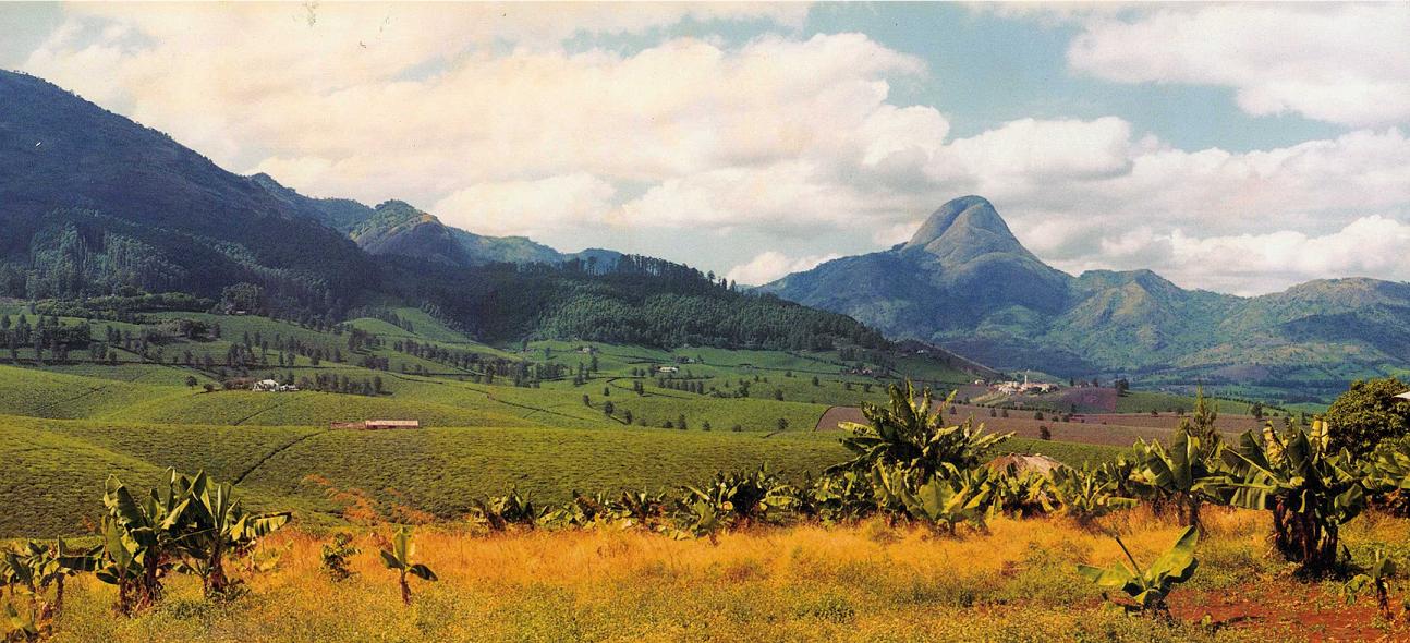
image_caption = In the background: MountMurresse ; near the center, to the right: "Plantações Manuel Saraiva Junqueiro" - tea factory.
flag_size =
image_
seal_size =
image_shield =
shield_size =
image_blank_emblem =
blank_emblem_size =
mapsize =
map_caption =
pushpin_
pushpin_label_position =
pushpin_mapsize =200
subdivision_type = Country
subdivision_name = MOZ
subdivision_type1 = Provinces
subdivision_name1 =Zambezia Province
subdivision_type2 = District
subdivision_name2 =
government_type =
leader_title =
leader_name =
leader_title1 =
leader_name1 =
established_title =
established_date =
established_title2 =
established_date2 =
established_title3 =
established_date3 =
area_magnitude =
unit_pref =
area_footnotes =
area_total_km2 =
area_land_km2 =
area_water_km2 =
area_total_sq_mi =
area_land_sq_mi =
area_water_sq_mi =
area_water_percent =
area_urban_km2 =
area_urban_sq_mi =
area_metro_km2 =
area_metro_sq_mi =
population_as_of =
population_footnotes =
population_note =
settlement_type =
population_total = 116992
population_density_km2 =
population_density_sq_mi =
population_metro =
population_density_metro_km2 =
population_density_metro_sq_mi =
population_urban =
population_density_urban_km2 =
population_density_urban_mi2 =
timezone =
utc_offset =
timezone_DST =
utc_offset_DST =
latd= 15 |latm= 28 |lats= |latNS=S
longd=36 |longm=59|longs= |longEW=E
elevation_footnotes =
elevation_m =
elevation_ft =
postal_code_type =
postal_code =
area_code =
website =
footnotes =Gurúè (also spelt Gurué; known before independence as "Vila Junqueiro") is located in the northern part of
Mozambique , near the center of the province ofZambezia . It is the country's largesttea estate. Population as of the 1997 census was 99,325, but current estimates are 116 922.History
The name Gurúè is said to be local tribal dialect (Lomwe) for "porco do mato" (
peccary ), or the name of a local tribal chief. Gurúè was founded and named by the Portuguese in the 19th century and developed as a majortea producing town starting in the 1930s. The Portuguese authorities promoted a thriving economic climate and local tea companies become major players in the industry. Chá Moçambique, Companhia da Zambézia, Chá Gurúè and Plantações Manuel Saraiva Junqueiro were the major tea companies headquartered in the town. With good natural attractions - Namuli mountain range (2419 m), large tea plantations ("chá" in Portuguese), and rivers, leading tea brands, such as "Chá Moçambique", "Chá Licungo", "Chá Gurúè", and "Chá Montebranco Junqueiro", achieved international recognition – most of the production was exported to theUnited Kingdom ,United States andCanada . Other agricultural activities were developed as well.In the 1940s, over 300 Portuguese lived in the small town of Gurúè which gravitated around the tea aristocracy who provided all the amenities for the entire working population, including a private small airline to the largest cities on the coast, like
Nampula , andQuelimane , the capital ofZambezia , inPortuguese East Africa . After the death of tea tycoon Manuel Saraiva Junqueiro, in an airplane crash, the town of Gurúè was renamed Vila Junqueiro in October 1959.By the late 1950s the town had grown, the cinema was founded and TAZ airline (Transportes Aéreos da Zambézia) increased its flights in the town’s airfield. Under Portuguese administration the town expanded harmoniously in terms of urbanism and architectural landscape. After the independence of Mozambique from Portugal in 1975, Vila Junqueiro returned to its original name, Gurúè, and started a process of deep deterioration and economic and social decline. The exodus of the Portuguese, the eruption of the
Mozambican Civil War (1977-1992) and the effects ofFRELIMO 's communist ideology, transformed the once thriving town in a few years. [Duarte Caires in DIÁRIO DE NOTÍCIAS DA MADEIRA, May 2008 - full text: [http://naodizesnada.blogspot.com/2008/03/um-ch-no-gur.html] ]Geography
Gurué is located in the North of the
Zambezia province, 350 km from the next international Airport inBlantyre, Malawi and also 350 km fromQuelimane orNampula , two of Mozambique's biggest cities.It is located at longitude 37 degrees 1 minute East and latitude 15 degrees 30 minutes South.Climate
Gurúè is considered to have a temperate climate. Summers have temperatures in the range of 30ºC to 34ºC. Winters have temperatures in the range of 17ºC to 20ºC. Like in tropical climates Winter is usually referred to as
rain season while Summer is calleddry season . Gurué's climate has much more rainfall than most of the rest of the province due to the effect of the mountains that surround the town. It creates a microclimate which is unusually cool and wet and therefore good for growing tea.Economy
Gurúè's economy depends mainly on the
tea plantations (90%), though other plantation types can also be found such ascoffee ,fruit , etc. Most people also have small subsistence farms to supplement their irregular salaries.Demographics
According to Mozambique's Government 1997 census, Gurúè's population was estimated at 99,325 and in 2008 at 116 922.cite web |url=http://world-gazetteer.com/wg.php?x=&men=gcis&lng=en&des=wg&srt=npan&col=abcdefghinoq&msz=1500&geo=-153 |title=Mozambique: largest cities and towns and statistics of their population |accessdate=2008-06-18 |work=World Gazetteer |date= ] Most people in the area speak
Lomwe .Transportation
Gurúè can be reached by car or airplane. But the roads are unpaved and get very bad in the rainy season. Also, there is only a small grass airstrip and there are no regular flights to Gurué.
Wildlife
A
1998 birding expedition to Gurúè re-discovered the country's only endemic,Namuli Apalis , unseen since it was discovered in1932 . It is now known to be thriving in forests in this area.According to a recent University of Cape Town scientific expedition "in a land of many natural treasures, Namuli (a mount near Gurúè, with 2419m and being the second highest mountain in Mozambique) is the jewel in the crown" and "a high-priority site for birds in Africa". [ [http://www.africanbirdclub.org/grf/namuliap.jpgNamuli Apalis] ]References
See also
*
Zambezia
*Roman Catholic Diocese of Gurué
Wikimedia Foundation. 2010.

