- Mariental, Germany
-
Mariental 

 MarientalLocation of Mariental within Helmstedt district
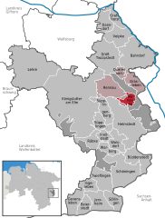

Coordinates 52°17′N 10°59′E / 52.28333°N 10.98333°ECoordinates: 52°17′N 10°59′E / 52.28333°N 10.98333°E Administration Country Germany State Lower Saxony District Helmstedt Municipal assoc. Grasleben Local subdivisions 2 Mayor Kurt Bartsch (CDU) Basic statistics Area 6.53 km2 (2.52 sq mi) Elevation 137 m (449 ft) Population 1,010 (31 December 2010)[1] - Density 155 /km2 (401 /sq mi) Other information Time zone CET/CEST (UTC+1/+2) Licence plate HE Postal code 38368 Area code 05356 Website www.samtgemeinde-grasleben.de Mariental is a municipality in the district of Helmstedt, in Lower Saxony, Germany.
Bahrdorf | Beierstedt | Büddenstedt | Danndorf | Frellstedt | Gevensleben | Grafhorst | Grasleben | Groß Twülpstedt | Helmstedt | Ingeleben | Jerxheim | Königslutter | Lehre | Mariental | Querenhorst | Räbke | Rennau | Schöningen | Söllingen | Süpplingen | Süpplingenburg | Twieflingen | Velpke | Warberg | Wolsdorf
References
- ^ "Bevölkerungsfortschreibung" (in German). Landesbetrieb für Statistik und Kommunikationstechnologie Niedersachsen. 31 December 2009. http://www1.nls.niedersachsen.de/statistik/html/parametereingabe.asp?DT=K1000014&CM=Bev%F6lkerungsfortschreibung.
Categories:- Municipalities in Lower Saxony
- Braunschweig region geography stubs


Wikimedia Foundation. 2010.