Mokopuna Island

Mokopuna Island
Mokopuna Island
Mokopuna (Māori)
Nickname: the 'grandchild'

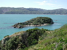
Mokopuna Island, from Matiu/Somes Island.
Geography
Coordinates 41°15′S 174°52′E / 41.25°S 174.867°E / -41.25; 174.867
Length 200 m (700 ft)
Width 80 m (260 ft)
Country
Demographics
Population 0

Mokopuna (the 'grandchild') Island is a small island in Wellington Harbour, New Zealand. It is about 200 metres (219 yd) on its long axis and about 80 metres (87 yd) across. It lies immediately north of the much larger Matiu/Somes Island, from which it is separated by a channel about 50 metres (55 yd) wide.

A number of wave-cut arches and caves line the shore. For about 3 months in 1904 one of these caves was the home of one Kim Lee, a Cantonese fruiterer who had been diagnosed (possibly mistakenly) as a leper. Even though Matiu/Somes was the human quarantine station at the time, Lee was exiled to Mokopuna, where he was supplied with food and water by a flying fox from Matiu/Somes.

Lee died on Mokopuna on 14 March 1904, and was buried on Matiu/Somes. Today Mokopuna is a bird reserve where gulls and Blue Penguins nest, and no landings are allowed.

Coordinates: 41°15′S 174°52′E / 41.25°S 174.867°E / -41.25; 174.867

See also

References

McGill, D., The Pioneers of Port Nicholson, 1984, A. H. & A. W. Reed, Wellington, N. Z. ISBN 0-589-01531-1

External links


Wikimedia Foundation. 2010.

Игры ⚽ Поможем написать курсовую

Look at other dictionaries:

  • Matiu/Somes Island — Matiu/Somes Island, at 24.9 ha, is the largest of three islands in the northern half of Wellington Harbour, New Zealand. It lies 3km south of the suburb of Petone and the mouth of the Hutt River, and about 5km northwest of the much smaller… …   Wikipedia

  • Matiu/Somes Island — Matiu vom Mount Kaukau aus gesehen Matiu von Normanda …   Deutsch Wikipedia

  • Somes Island — Matiu vom Mount Kaukau aus gesehen Matiu von Normandale aus gesehen Matiu/Somes Island ist mit einer Fläche von 24,9 Hektar die größte von drei Inseln in der nördlichen Hälfte der Hafens von …   Deutsch Wikipedia

  • Wellington — Infobox Settlement name = Wellington official name = other name = native name = Te Whanga nui a Tara (in Māori) nickname = Wellywood, the Windy City, Windy Wellington settlement type = main urban area total type = motto = imagesize = 300px image… …   Wikipedia

  • Matiu — vom Mount Kaukau aus gesehen Matiu von Normandale aus gesehen Matiu/Somes Island ist mit einer Fläche von 24,9 Hektar die größte von drei Inseln in der nördlichen Hälfte der Hafens von …   Deutsch Wikipedia

  • Wellington Harbour — is the large natural harbour on the southern tip of New Zealand s North Island. New Zealand s capital, Wellington, is located on the western side of Wellington Harbour. The harbour was officially named Port Nicholson [… …   Wikipedia

  • Port Nicholson — Wellington Harbour. 1 markiert Wellington, 2 und 3 ist Lower und Upper Hutt, und 4 ist Porirua Wellington Harbour ist der große Naturhafen an der Südspitze der Nordinsel Neuseelands. Die neuseeländische Hauptstadt Wellington liegt an seiner… …   Deutsch Wikipedia

  • Wellington Harbour — Wellington Harbour. 1 markiert Wellington, 2 und 3 ist Lower und Upper Hutt, und 4 ist Porirua Wellington Harbour ist der große Naturhafen an der Südspitze der Nordinsel Neuseelands. Die neuseeländische Hauptstadt Wellington liegt an seiner… …   Deutsch Wikipedia

  • Port Nick — Wellington Spitzname: Windy Wellington Lage …   Deutsch Wikipedia

  • WGN — Wellington Spitzname: Windy Wellington Lage …   Deutsch Wikipedia

Share the article and excerpts

Direct link
Do a right-click on the link above
and select “Copy Link”