Okushiri Island

Okushiri Island
Okushiri
Native name: 奥尻島, Okushiri-tō
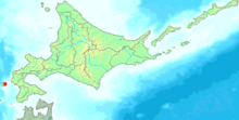
Geography
Location East Asia
Coordinates 42°08′57″N 139°28′02″E / 42.14917°N 139.46722°E / 42.14917; 139.46722Coordinates: 42°08′57″N 139°28′02″E / 42.14917°N 139.46722°E / 42.14917; 139.46722
Archipelago Japanese archipelago
Area 142.97 km2 (55.201 sq mi)
Length 27 km (16.8 mi)
Width 11 km (6.8 mi)
Coastline 84 km (52.2 mi)
Highest elevation 584 m (1,916 ft)
Highest point Mount Kamui
Country
Japan
Prefectures Hokkaidō
Subprefectures Hiyama Subprefecture
District Okushiri District
Demographics
Population 3343 (as of 2009-03-31)
Density 23.4 /km2 (60.6 /sq mi)
Ethnic groups Japanese

Okushiri Island (奥尻島 Okushiri-tō?) is an island in Hokkaidō, Japan. It has an area of 142.97 square kilometres (55.20 sq mi). The town of Okushiri and Hiyama Prefectural Natural Park encompass the entire island.

History

It was the site of a powerful earthquake and tsunami in 1993.[1]

The name Okushiri comes from the Ainu name Ikusyun-shiri. The phonetic word iku means other side and shiri means island.[2] However, the Japanese meaning of the two kanji used for the name mean "wife's hips" or "wife's buttocks".

Transportation

Okushiri Airport serves the island.

References

  1. ^ HIRATA, YUZUKI; MASAKAZU MURAKAMI (Thursday, Nov. 16, 2006). "Island hit by 1993 killer tsunami remains vigilant". Japan Times (The Japan Times Ltd.). http://search.japantimes.co.jp/cgi-bin/nn20061116f2.html. Retrieved 2009-06-25. 
  2. ^ "About location and geography of Okushiri-cho". Official Home Page of Okushiri Town. Okushiri Town. http://www.town.okushiri.lg.jp/en/gaiyo/ichi_chisei.html. Retrieved 2009-07-01. 


Wikimedia Foundation. 2010.

Игры ⚽ Нужна курсовая?

Look at other dictionaries:

  • Okushiri, Hokkaidō — Okushiri 奥尻町   Town   Location of Okushiri in Hokkaidō (Hiyama …   Wikipedia

  • Okushiri Airport — 奥尻空港 Okushiri Kūkō IATA: OIR – ICAO: RJEO Summary …   Wikipedia

  • Okushiri — may refer to Okushiri Island Okushiri, Hokkaido, the main town on the island This disambiguation page lists articles about distinct geographical locations with the same name. If an internal link led you here, you …   Wikipedia

  • Okushiri District, Hokkaidō — The area of Okushiri District in Hiyama Subprefecture. Okushiri (奥尻郡, Okushiri gun …   Wikipedia

  • Okushiri (Insel) — Okushiri Okushiri (gelb braun, links) Gewässer Japanisches Meer (Pazifischer Ozean) …   Deutsch Wikipedia

  • Okushiri — Isla Okushiri 奥 尻 岛 Okushiri tō Localización País  Japón Prefectura …   Wikipedia Español

  • Mount Kamui (Okushiri) — Mount Kamui 神威山 Elevation 584 m (1,916 ft) Listing …   Wikipedia

  • Historic tsunamis — Location= Tsunamis occur most frequently in the Pacific Ocean, but are a global phenomenon; they are possible wherever large bodies of water are found, including inland lakes, where they can be caused by landslides. Very small tsunamis, non… …   Wikipedia

  • Hokkaido — For the dog breed, see Hokkaido (dog). Hokkaido Japanese transcription(s)  – Japanese 北海道  – Rōmaji Hokkaidō …   Wikipedia

  • Hokkaidō — ) or Ezogashima. The Ezo mainly relied upon hunting and fishing and obtained rice and iron through trade with the Japanese.During the Muromachi period, the Japanese created a settlement at the south of the Oshima peninsula. As more people moved… …   Wikipedia

Share the article and excerpts

Direct link
Do a right-click on the link above
and select “Copy Link”