Desolación Island

Desolación Island
Desolación Island at the Strait of Magellan

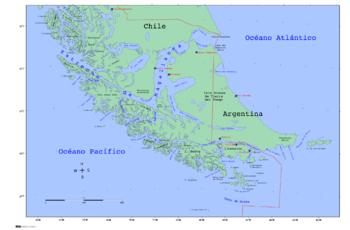
Desolación Island is an island at the western end of the Strait of Magellan in the Magallanes y la Antártica Chilena Region, Chile. It belongs to the Tierra del Fuego archipelago. Its area is 1,352 square kilometres (522 sq mi) and the highest point is Monte Harte Dyke, at 1,097 metres (3,599 ft).

Desolación Island in fiction

The Douglas Preston and Lincoln Child novel The Ice Limit described an expedition to Isla Desolacion near Cape Horn in Chile. The map in the (paperback) edition incorrectly identifies easterly Isla Wollastone as Isla Desolacion.

James Michener's novel "Hawaii" depicts an attempt by a sailing ship to pass the Straits of Magellan, describing the western exit past Desolation Island as the most difficult part of the passage.

Coordinates: 53°00′S 74°10′W / 53°S 74.167°W / -53; -74.167


Wikimedia Foundation. 2010.

Игры ⚽ Нужен реферат?

Look at other dictionaries:

  • Santa Inés Island — Infobox Islands name = Santa Inés image caption = image size = locator Location map|Chile|width=50|float=center|lat= 53.75|long= 72.75 map custom = yes native name = native name link = nickname = location = Zona Austral coordinates =… …   Wikipedia

  • Desolation Island — is a name that has been used for several islands. The largest and best known is Kerguelen Island in the Indian Ocean. Places Desolación Island, Chile. Desolation Island (South Shetland Islands). Desolation Island is a novel in the Aubrey–Maturin… …   Wikipedia

  • Punta Arenas, Chile — Infobox City official name = Punta Arenas other name = Magallanes native name = motto = imagesize =250px image caption =View of the city of Punta Arenas. In the background the Strait of Magellan and the north coast of Tierra del Fuego ( Isla… …   Wikipedia

  • Straits of Magellan — The Straits of Magellan (rarely referred to as the Magellanic Straits) comprise a navigable sea route immediately south of mainland Chile and north of Isla Grande de Tierra del Fuego. The waterway is the most important natural passage between the …   Wikipedia

  • Strait of Magellan — The Strait of Magellan (also called the Straits of Magellan or the Magellanic Strait) comprises a navigable sea route immediately south of mainland South America and north of Tierra del Fuego. The waterway is the most important natural passage… …   Wikipedia

  • Magellan, Strait of — Spanish Estrecho de Magallanes Strait, linking the Atlantic Ocean and Pacific Ocean, between the southern tip of South America and Tierra del Fuego. It extends westward from the Atlantic between Cape Vírgenes and Cape Espíritu Santo and curves… …   Universalium

  • Islas por superficie — Anexo:Islas por superficie Saltar a navegación, búsqueda st. Aunque una isla es, en general, cualquier masa de tierra que esté completamente rodeada de agua, normalmente se suele excluir las masas de tierra lo suficientemente grandes como para… …   Wikipedia Español

  • Anexo:Islas por superficie — Aunque una isla es, en general, cualquier masa de tierra que esté completamente rodeada de agua, normalmente se suelen excluir las masas de tierra lo suficientemente grandes como para ser consideradas continentes. Al clasificar a Australia como… …   Wikipedia Español

  • Gabriela Mistral — Para otros usos de este término, véase Gabriela Mistral (desambiguación). Gabriela Mistral …   Wikipedia Español

  • Liste der größten Inseln der Erde — Die Inseln der Erde Grönland, die größte Insel …   Deutsch Wikipedia

Share the article and excerpts

Direct link
Do a right-click on the link above
and select “Copy Link”