- Biliran Island
Infobox Islands
name = Biliran Island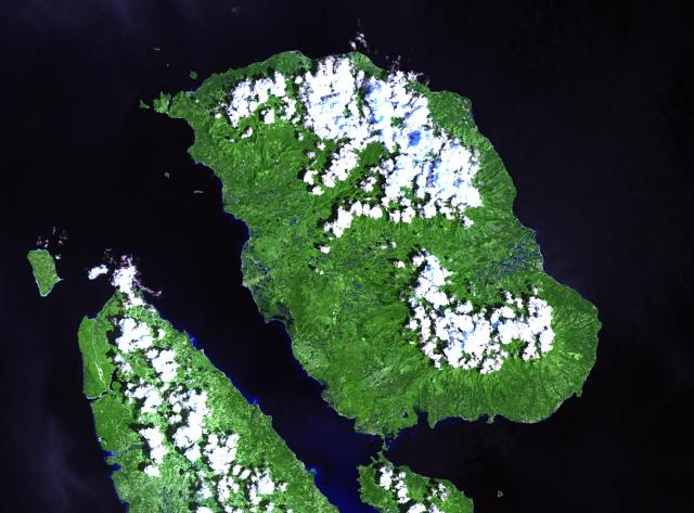
image caption = NASA Landsat image of Biliran.
native name =
native name link =
locator
Location map|Philippines|lat=11.523|long=124.535|width=175
map_custom = yes
location =South East Asia
coordinates= coord|11.523|N|124.535|E|type:mountain
archipelago =Visayas
total islands =
major islands = Bohol, Cebu, Leyte, Masbate,Negros , Panay, Samar
area = 555.4 km²
highest mount =
elevation = 1,301 m
country = Philippines
country admin divisions title = Municipality/Town
country admin divisions = Almeria, Biliran, Cabucgayan, Caibiran, Culaba, Kawayan, Maripipi, Naval
country largest city = Naval
country largest city population = 37,974
population = 140,274
population as of = 2000
density = 253
ethnic groups = Visayan, (Cebuano, Waray):"This article is about the island. For the municipality, seeBiliran, Biliran . For the province, seeBiliran . "Biliran is a volcanic island in the central Philippines.
*Classification: Active
*Current Summit Activities: Solfataric
*Province: Biliran Region VIII
*Nearby Cities/Towns:Kawayan, Biliran Almeria, Biliran Culaba, Biliran Calubian, Biliran Naval, Biliran Caibiran, Biliran San Isidro, Biliran Biliran, Biliran Cabucgayan, Biliran
*Topo Sheets: 3854 I, 3855 II, 3955 III, 3854 II, 3954 IIIInfobox Mountain
Name= Biliran
Photo=
Caption=
Elevation=1,301 m (4,268 ft)
Location=Visayas ,Philippines
Prominence =
Coordinates = coord|11.523|N|124.535|E|type:mountain
Topographic
Type=Complex volcano
Age=
Last eruption=1939
First ascent=
Easiest route=Physical features
*Hotsprings:
- Central Biliran - Libtong Thermal Areas (12 hot springs and one bubbling pool)
- North Biliran - Panamao Thermal Area
- Anas Thermal Area
- South Biliran - Kalambis Thermal Area
*Adjacent Volcanic Edifice:- Panamao (107 m asl)
- Gumansan (1064 m asl)
- Lauan (1187 m asl)
- Suiro (1301 m asl)
Geological features
*Rock Type: Hornblende andesite containing greenish and black hornblende
*Tectonic Setting: Biliran Volcano is part of the curvilinear belt of Quaternary volcanoes in easternPhilippines , parallel to Phil. Trench to the eastVolcanic activity
*Number of Historical Eruptions: 1
*Latest Eruption/Activity: September 26, 1939
*Site: crater
*Eruption Character: Debris avalanche
*Affected Areas/Remarks: Ashfall at Caibiran and adjoining areas (6.35 cm thick deposits)
*Monitoring activity: Short-term monitoring in 1954References
* [http://www.volcano.si.edu/world/volcano.cfm?vnum=0702-08= Global Volcanism Program: Biliran]
External links
* [http://www.biliranisland.com BiliranIsland.com]
Wikimedia Foundation. 2010.