Erie Harbor North Pier Light
- Erie Harbor North Pier Light
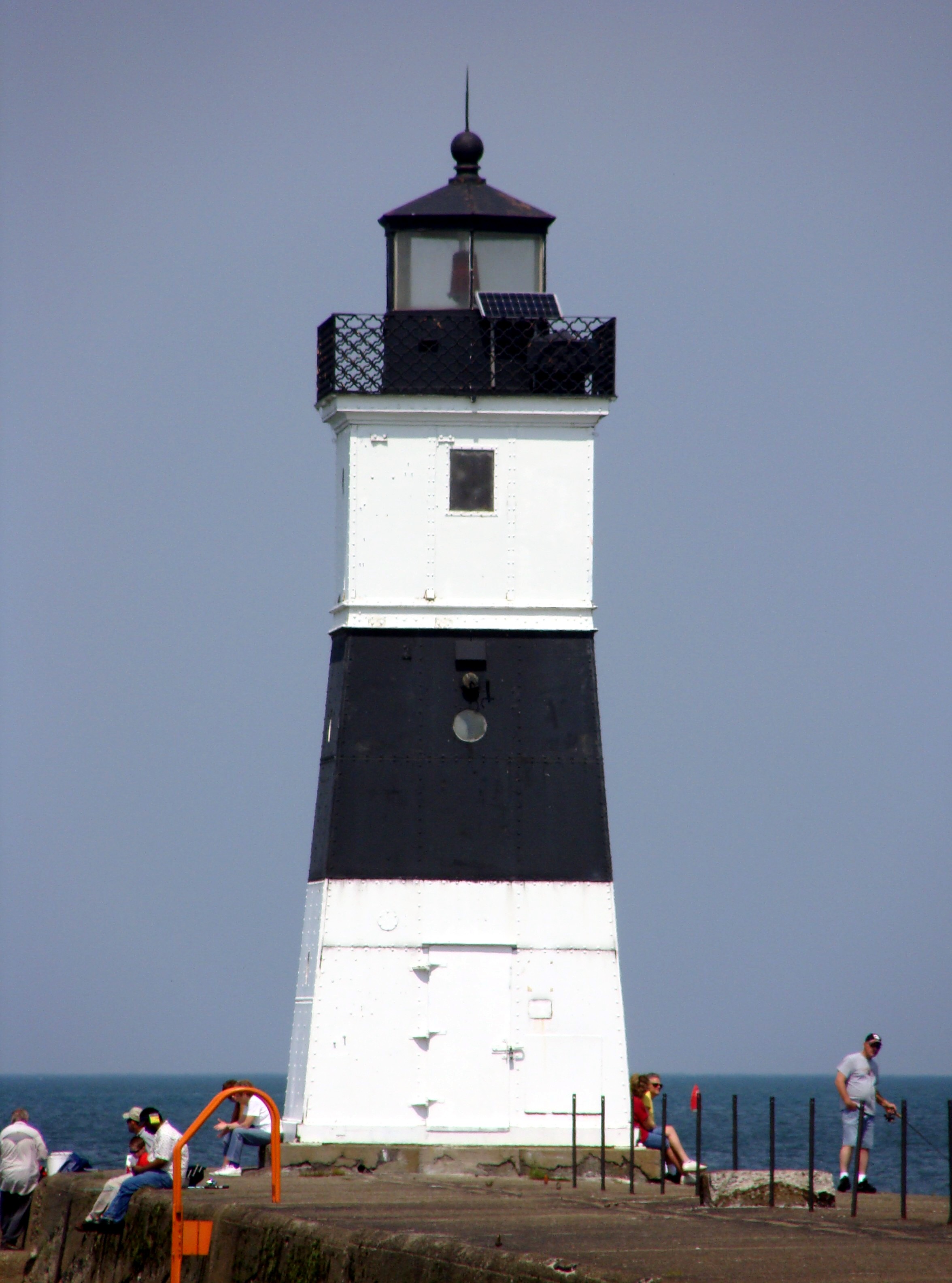
Infobox Lighthouse
location = Presque Isle State Park, Pennsylvania, United States
coordinates = coord|42|09|24.12|N|80|04|14.16|W|region:US_type:landmark
yearbuilt = 1858
automated = Yes
foundation = Pier [cite web |title=Erie Harbor North Pierhead Light |date=December 6, 2002 |publisher=National Park Service |accessdate=2007-05-24 |url=http://www.cr.nps.gov/maritime/light/erieharb.htm]
construction = Wrought iron encased in steel
shape = Square pyramidal
marking = White with black horizontal band
height = convert|34|ft
lens = Fourth order Fresnel
range =
characteristic = Red, Flashing
ARLHS = [http://wlol.arlhs.com/lighthouse/USA274.html USA-274]
The Erie Harbor North Pier Light, also known as the Presque Isle North Pier Light, is one of the three lighthouses near Erie, Pennsylvania in the United States. The light, situated at the far eastern end of Presque Isle State Park, helps mariners as they traverse the narrow inlet between Lake Erie and Presque Isle Bay.
Originally constructed as a wooden tower in 1830, that light was swept away by a schooner in 1857. [cite book |last=Bates |first=Samuel P |title=History of Erie County |year=1884 |publisher=Warner, Beers & Co |location=Chicago] The current structure was forged in France and assembled on site in Erie. It was moved in 1882] and again in 1940. The United States Coast Guard, which operates the beacon, changed its fixed red beam to an automated red flashing light in 1995, at which time the 4th order Fresnel lens was sent to the Erie Maritime Museum.
References
Wikimedia Foundation.
2010.
Look at other dictionaries:
North Pier Light — may refer to: Duluth North Pier Light in Duluth, Minnesota Erie Harbor North Pier Light on Presque Isle in Erie, Pennsylvania Kenosha North Pier Light in Kenosha County, Wisconsin. Sturgeon Bay Canal North Pierhead Light near Sturgeon Bay in Door … Wikipedia
Erie, Pennsylvania — Erie redirects here. For other uses, see Erie (disambiguation). Coordinates: 42°7′46.42″N 80°5′6.77″W / 42.1295611°N 80.0852139°W … Wikipedia
Milwaukee Pierhead Light — Location Milwaukee, Wisconsin Coordinates … Wikipedia
North River (Hudson River) — North River in red, if defined as portion between New Jersey and Manhattan … Wikipedia
Lighthouses in the United States — This United States has hundreds of lights as well as light towers, range lights, and pier head lights. Michigan has the most lights of any state with over 130. See also: Lightvessels in the United States, lightvessel, List of lighthouses and… … Wikipedia
Detroit River Light — Undated U.S.C.G. photo Location Lake Erie south of Detroit River Year first constructed 1875 (lightship) 1885 (current tower) Automated 1979 Foundation … Wikipedia
Milwaukee Breakwater Light — Milwaukee Breakwater Lighthouse Location Milwaukee, Wisconsin Coordinates … Wikipedia
Presque Isle State Park — Geobox Protected Area name = Presque Isle State Park native name = other name = other name1 = category local = Pennsylvania State Park category iucn = III image size = 300 image caption = Aerial view of Presque Isle toward the east northeast… … Wikipedia
Old Presque Isle Light — This article is about the lighthouse on Lake Huron in Northern Michigan. For the lighthouse in Pennsylvania, see Erie Land Light. Old Presque Isle Light Location Presque Isle, Michigan Coordinates … Wikipedia
History of Presque Isle — The History of Presque Isle began when Presque Isle was created by the wave action of Lake Erie over the course of the 11,000 years that have passed since the last ice age.cite web| url=http://www.dcnr.state.pa.us/STATEPARKS/parks/presqueisle… … Wikipedia