- Maungati
-
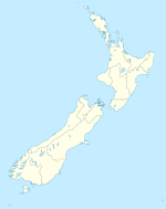
Maungati is a lightly populated locality[1] situated approximately 18 miles southwest of Timaru in the Canterbury region of New Zealand's South Island. It is a small farming community in an area with primarily sheep and cattle farming and some deer farming, and it has a 9 hole golf course and Māori rock drawings.
Maungati comes from the Māori language words "maunga", meaning "mountain", and "ti", meaning "cabbage tree", and thus means "mountain of cabbage tree". There are many cabbage trees in the area.
References
- ^ "Place Name Detail: Maungati". New Zealand Geographic Placenames Database. Land Information New Zealand. http://www.linz.govt.nz/placenames/find-names/topographic-names-db/database/index.aspx?p=15522. Retrieved 20 May 2005.
Coordinates: 44°27′S 170°56′E / 44.45°S 170.933°E
Towns of the Waimate District, Canterbury, New Zealand Main Towns Glenavy • Hakataramea • Makikihi • Morven • Saint Andrews • Studholme • Waimate(seat) • WillowbridgeLocalities Arno • Blue Cliffs • Broad Gully • Cattle Creek • Cup and Saucer Junction • Deep Creek • Dog Kennel • Douglas • Elephant Hill • Esk Valley • Green Hills • Gordons Valley • Grays Corner • Gum Tree Flat • Hakataramea Downs • Hakataramea Valley • Hook • Hook Bush • Hunter • Ikawai • Kapua • Kohika • Kowhatu • Lyalldale • Maungati • Maungatiro • Maytown • Norton Reserve • Nukuroa • Otaio • Otaio Gorge • Pentland Hills • Pikes Point • Riverview • Springbrook • Southburn • Struan • Tawai • Te Waimate • Uretane • Waiariari • Waihao Downs • Waihao Forks • Waihaorunga • Waikakahi • Waituna
Categories:- Waimate District
- Populated places in New Zealand
Wikimedia Foundation. 2010.

