Dumgoyne

Dumgoyne
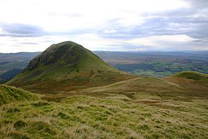
Dumgoyne viewed from the east

Dumgoyne is a hill prominent on the edge of the Campsie Fells and is a well known landmark visible from Glasgow. It is a volcanic plug and is 427 m high (1,402 feet). The plug is readily reached from a path beside Glengoyne Distillery or via a water-board track from the village of Strathblane three miles to the east.

From Strathblane, the path begins at the entrance to a private road. Here the car can be parked by the roadside, and the walk begins by following this private road for approximately two miles. After passing several gates on the way, turn to the right where theres another gate. Follow this path up and around the side Dumfoyn, and from here the path steepens, as it goes up Dumgoyne. The summit is marked by a small standing stone erected some years ago by local Rotarians. This route to Dumgoyne passes close to the Spittal of Ballewan (545811) the former site of a medieaval Knights Templar Hospital.

Close to Dumgoyne is Dumfoyn(547825; 421m) a similar but less remarkable and much less climbed hill. From these hills the much smaller but heavily wooded Dumgoyach(531810;108m) can be seen. This fine hill is well worth a visit if one is walking on the West Highland Way as the Way goes beside Dumgoyach. However, do not damage any fences as it is exclusion of sheep that has allowed Dumgoyach to retain its wooded slopes. Dumgoyach due to its association with the Edmonstons of Duntreath provides a historic link with Alice Keppel and the Duchess of Rothesay, Duchess of Cornwall, Camilla, Duchess of Cornwall.

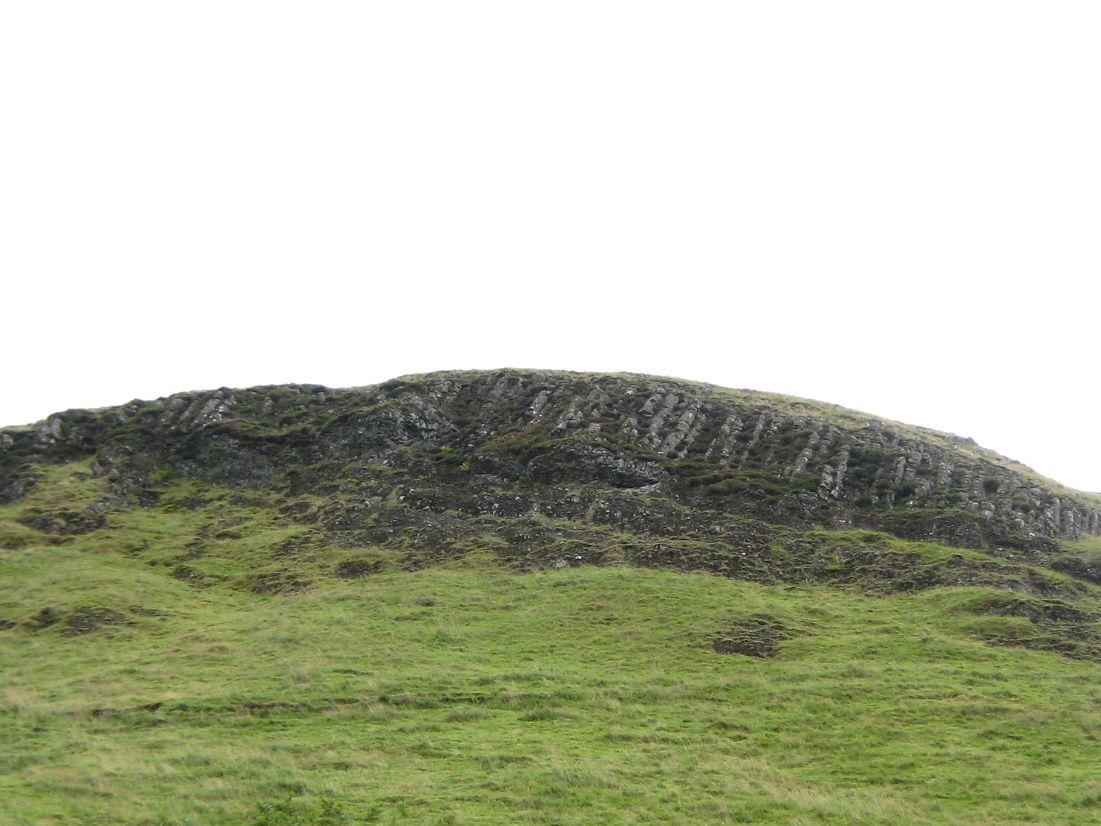
Columnar basalt visible of the west face of Dumgoyne

External links

Coordinates: 56°00′54″N 4°20′31″W / 56.01495°N 4.34201°W / 56.01495; -4.34201


Wikimedia Foundation. 2010.

Игры ⚽ Поможем решить контрольную работу

Look at other dictionaries:

  • Glengoyne — Distillerie Pays Écosse Ville Dumgoyne (Highlands) Coordonnées …   Wikipédia en Français

  • List of distilleries in Scotland — is an incomplete list of distilleries in Scotland. =Currently operating Scottish whisky distilleries= * Aberfeldy , Aberfeldy, Perth and Kinross/Highlands (Midlands) * Aberlour , in Charlestown of Aberlour, Speyside * Allt á Bhainne ,… …   Wikipedia

  • Aberfoyle, Stirling — infobox UK place country = Scotland static static image caption= latitude= 56.1812 longitude= 4.3877 official name =Aberfoyle population= 576 [cite web|publisher=Scotland s Census Results Online|title =Comparative Population Profile: Aberfoyle… …   Wikipedia

  • Drymen — The Square, Drymen Drymen Coordinates …   Wikipedia

  • Glengoyne Single Malt — Whisky is a brand of Single malt Scotch whisky. The single malt whisky has been distilled at Glengoyne Distillery since 1833. The name Glengoyne comes from Glenguin or Glen of the Wild Geese .Unlike many other whiskies, the distillery does not… …   Wikipedia

  • Campsie Fells — The Campsie Fells are a range of hills in central Scotland, stretching east to west, from south Stirling to Dumgoyne in East Dunbartonshire. The highest point in the range is Earl s Seat which is 578 m (1897 feet) high. The range overlooks the… …   Wikipedia

  • Strathblane — infobox UK place country = Scotland official name= Strathblane gaelic name= Strath Bhlàthain scots name= population= 1,811 (2001 Census) population density= Pop density km2 to mi2|54|precision=0|abbr=yes|wiki=yes area total sq mi= 17 os grid… …   Wikipedia

  • Dumfoyn — Coordinates: 56°00′47″N 4°20′06″W / 56.013°N 4.335°W / 56.013; 4.335 Dumfoyn is a hill in the Campsie Fell …   Wikipedia

  • Glengoyne — Destillerie und Lagerhäuser Land Schottland Region Highlands …   Deutsch Wikipedia

Share the article and excerpts

Direct link
Do a right-click on the link above
and select “Copy Link”