- Dörgicse
-
Dörgicse 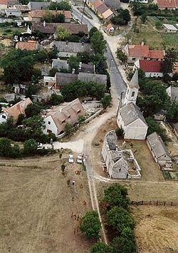
Coat of armsLocation of Dörgicse
 Dörgicse
Coordinates: 46°55′06″N 17°43′23″E / 46.91840°N 17.72293°ECoordinates: 46°55′06″N 17°43′23″E / 46.91840°N 17.72293°E Country  Hungary
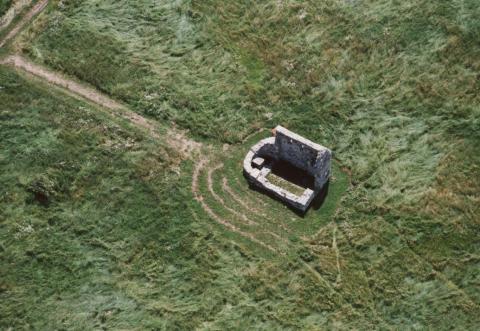
County Veszprém Area – Total 19.12 km2 (7.4 sq mi) Population (2004) – Total 289 – Density 15.11/km2 (39.1/sq mi) Time zone CET (UTC+1) – Summer (DST) CEST (UTC+2) Postal code 8244 Area code(s) 87 Dörgicse is a village in Veszprém county, Hungary. It consists of three hamlets (Felsõdörgicse, Alsódörgicse and Kisdörgicse) built on separate hills[1] 4.3 km (2.7 m) north of Lake Balaton[2]. Dörgicse is famous for the wine production[3] and its three medieval churches[4] which were devastated during the Turkish wars in the 16th and 17th centuries[5].
Gallery
External links
References
- ^ Abend, Bernhard (2005) (in German). Ungarn. Mair Dumont Baedeker. pp. p. 166. ISBN 3829710925.
- ^ Nagy, Valér (1983). Gyula Németh. ed (in German). Ungarn: Ein grosser Reiseführer. Corvina. pp. p. 178. ISBN 963131507X.
- ^ Zwack, Anne Marshall (1990-06-03). "Lake Balaton, Where Hungary Summers". New York Times. http://query.nytimes.com/gst/fullpage.html?res=9C0CE6DB1F31F930A35755C0A966958260&sec=travel&spon=. Retrieved 2008-01-20.
- ^ Dercsényi, Dezső (1969). Historical Monuments in Hungary: Restoration and Preservation. Corvina. pp. p. 92.
- ^ Eickhoff, Matthias; Kim Hendrikx, Pieter Streutker, Bureau Werkwoord (2003) (in Dutch). Balaton: Hongarije. ANWB Media Boeken. pp. p. 85. ISBN 9018016276.
Categories:- Populated places in Veszprém county
- Veszprém county geography stubs
-


Wikimedia Foundation. 2010.