- Lnáře
Geobox | Settlement
name = Lnáře
other_name = Schlüßelburg
category = village
image_caption =

symbol = Lnare znak.jpg
etymology =
official_name =
motto =
nickname =
country = Czech Republic
country_
state =Prachens
region = South Bohemian
region_type = Region
district = Strakonice
district_type = District
commune = Blatná
municipality = Lnáře
part =
river =
location =
elevation = 565
lat_d = 49
lat_m = 27
lat_s = 29
lat_NS = N
long_d = 13
long_m = 47
long_s = 16
long_EW = E
highest =
highest_elevation =
highest_lat_d =
highest_long_d =
lowest =
lowest_elevation =
lowest_lat_d =
lowest_long_d =
area = 12.51
area_round = 2
population = 756
population_date = 2006-07-03
population_density = auto
established = 1318
established_type = First mentioned
mayor = Stanislava Mašková
timezone =
map_background = Czechia - background map.png
map_locator = Czechia
commons = Lnáře
statistics = [http://www.statnisprava.cz/ebe/ciselniky.nsf/i/551350 statnisprava.cz]
website = [http://www.lnare-obec.cz/ www.lnare-obec.cz]
footnotes =Lnáře (German: "Schlüßelburg") is a small municipality in the
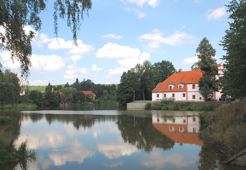
Czech Republic , located 35 km northwest ofPisek city or 50 km southeast ofPilsen . It is situated on the shores of three ponds within municipal borders in the northwest corner of the formerly autonomous Prachensky Kray, today in theStrakonice District . The name of municipality is from the Slavic word "len" ("flix ") and combined with a suffix which gives a meaning of "flix-makers" or "flix producers". The German name is in remembrance of a different fact – "Schlüssel" means "key" and "Burg" means "stronghold": in the second part of the 17th century a golden key was found in the building site of local New Castle.History
The municipality is the former centre of a vast agrary husbandry including two small towns and about 50 villages in its proximity (only the small settlement
Zahorčice is still administered by Lnáře). Such was the situation between the mid-15th century and the mid-19th century. After this period of relative prosperity (with a few pauses incurred by civil convulsions) emerged an era of nationwide population decline in all counties in Central Europe (with exceptions in entirely undeveloped mountainous counties in theCarpathian Mountains system etc.), and the local population significantly decreased to the current number of less than 830 people.The oldest mention of Lnáře or Schlüsselburg dates back to 1319, when it was referenced to the local Old Chateau (former stronghold from wood) as the site of the landlord of Lnáře district (later Knights of Lnáře). Lnáře was a village drowned in sea of woods on the shores of muddy streams in
moorland . This moorland was (as in case of townTřeboň ) very soon turned into a basin with dozens of ponds and lakes, later numbering four hundred. New kinds of unscalycarp were cultivated in the 19th century by Theodor Mokry, with the name "Lnarsky modrak" ("Bluefish of Lnáře"). A train line was built between the towns ofBlatná andNepomuk (local name "Pomuk") near the start of the 20th century leading near Lnare municipality, which is still in use. The construction of theEuropean route E49 through Lnáře was also beneficial for the local population.Lnáře today
Lnáře has two chateaux: the Old Chateau and the New Chateau. The Old Chateau is 690 years old, while the New Chateau is only about 340 years old. Between them is an
English garden (1 ha²) with a few pools, many flower-beds of roses, a fountain, a small baroque mosque with two lowminaret s and beautiful old trees with sculptures of the ancients gods carved by a famous baroque sculptor. The New Chateau is adorned with great paintings of dozens Greek gods. In its Big Hall was signed the treaty for theDissolution of Czechoslovakia .fact|date=May 2008 The Old Chateau is used for municipality needs, including as a gallery andbibliotheca , as well as leasing space for doctors and masseuses and flats for rent.Lnáře is divided into five quarters: "Mala Strana" (Lesser Part), "Svata Anna" (Saint Anna), "Pristav" (the harbour), "Zamky" (chateaux) and "Centrum" (the Centre). Saint Anna, with the Monastery of the shoeless
Augustinians and church, dates back to the 18th century. Today these buildings are used for government purposes, mainly as an insane asylum, but it will stop its activity in time. Aside from this, Lnáře has three more places for prayers – the Chapel of Adventist Church in the New Chateau, the Catholic Church by the graveyard and the Chapel ofHussite Church in the centre of municipality.A new development is the dense system of tourism cycle-ways with rest places. These cycle-ways are created for all kinds of people, allowing them to visit all the landmarks of the unique local landscape.


Wikimedia Foundation. 2010.