Lower Curtis Glacier

Lower Curtis Glacier

Infobox_Glacier | glacier_name = Lower Curtis Glacier
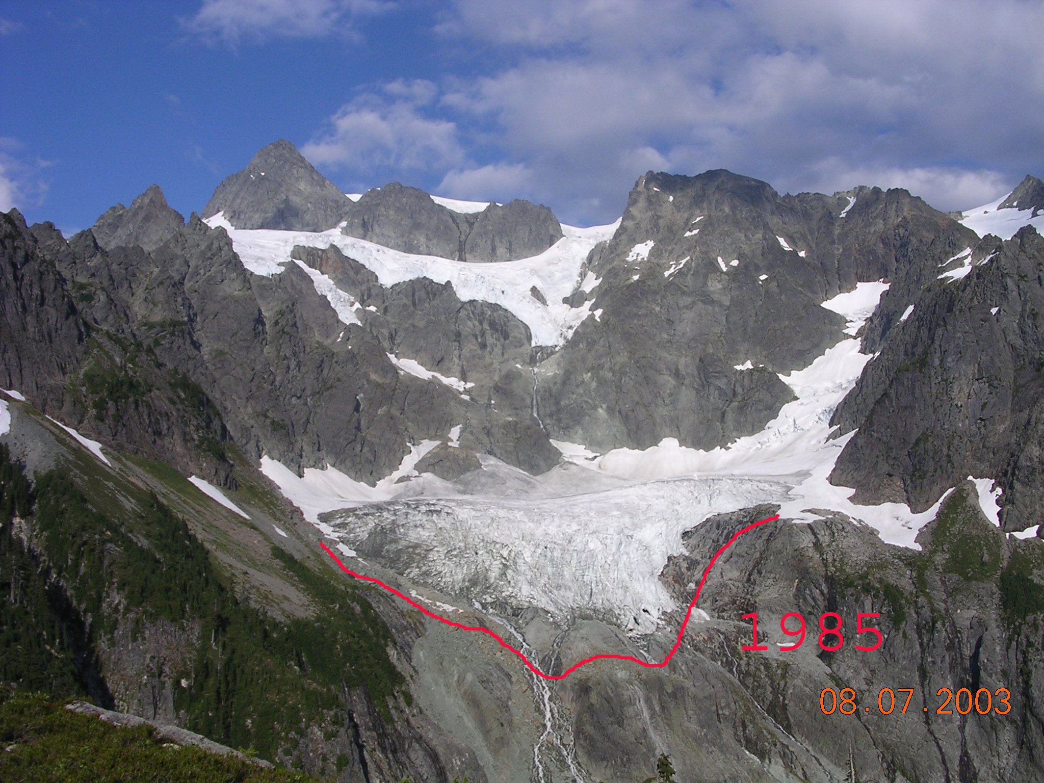


caption = Lower Curtis Glacier showing glacial retreat documented between 1985 and 2003
type = Mountain glacier
location = Washington, United States
coordinates = coord|48|49|25|N|121|37|16|W|type:glacier
area = 0.8km² (197 acres)
length =
thickness =
terminus = cliffs
status = retreating

Lower Curtis Glacier is located in North Cascades National Park, in the U.S. state of Washington. The glacier is in a cirque on the western slopes of Mount Shuksan. [cite web| first=| last=|title =Lower Curtis Glacier, USGS Mount Shuksan (WA) Topo Map| work =USGS Quad maps|publisher =TopoQuest| date =| url =http://www.topoquest.com/map.php?lat=48.82629&lon=-121.62162&datum=nad27&zoom=4| format =Map| accessdate = 2008-05-17] Lower Curtis Glacier is rapidly retreating and has a negative mass balance, meaning that the rate of snow and ice that is falling in the accumulation zone is less than that which is lost each year in the ablation zone. Between 1908 and 1984, the glacier experienced a loss of thickness by 45 meters (147 ft). Between 1984 and 2002, the glacier lost another 6 meters (19 ft) in thickness. Lower Curtis Glacier also lost 28% of its surface area between the end of the little ice age (around 1850) and 1950. Between the years 1951 and 1979, the glacier actually lengthened by 245 meters (800 ft) but has retreated 184 m (600 ft) since 1985, partly due to the tongue of the glacier being on a steep precipice which may have increased the loss of ice at the termini. [cite conference| first =Mauri| last =Pelto| coauthors =Paula Hartzell| title =Change in Longitudinal Profile on Three North Cascade Glaciers During the Last 100 Years| booktitle =60th Eastern Snow Conference| pages = 89-96| date = 2003| location =Sherbrooke, Québec, Canada| url =http://www.easternsnow.org/proceedings/2003/pelto_and_hartzell.pdf| accessdate =2007-05-03]

Cited references

ee also

* List of glaciers


Wikimedia Foundation. 2010.

Игры ⚽ Нужна курсовая?

Look at other dictionaries:

  • Cirque glacier — Lower Curtis Glacier is a corrie glacier in the North Cascades in the State of Washington A cirque glacier is formed in a cirque, bowl shaped depressions on the side of or near mountains. Snow and ice accumulation in corries often occurs as the… …   Wikipedia

  • Asahel Curtis — photo of Seattle in 1900. Asahel Curtis (1874–1941) was a Pacific Northwest photographer. Contents 1 Birth …   Wikipedia

  • Cirque — For other uses, see Cirque (disambiguation). Two cirques with semi permanent snowpatches in Abisko National Park, Sweden …   Wikipedia

  • North Cascades National Park — IUCN Category Ib (Wilderness Area) …   Wikipedia

  • Antarctica — /ant ahrk ti keuh, ahr ti /, n. the continent surrounding the South Pole: almost entirely covered by an ice sheet. ab. 5,000,000 sq. mi. (12,950,000 sq. km). Also called Antarctic Continent. * * * Antarctica Introduction Antarctica Background:… …   Universalium

  • Everglades National Park — IUCN Category Ib (Wilderness Area) …   Wikipedia

  • Geology of the Capitol Reef area — [ Waterpocket Fold is the major geographic feature in the area of the park. This view is from above Capitol Reef Scenic Drive looking back at the west face of the broken and eroded fold.] The exposed geology of the Capitol Reef area presents a… …   Wikipedia

  • Montana — This article is about the U.S. state of Montana. For other uses, see Montana (disambiguation). State of Montana …   Wikipedia

  • Mount Rainier — This article is about the volcano. For other uses, see Mount Rainier (disambiguation) and Rainier. Mount Rainier Mount Rainier as viewed from the northeast …   Wikipedia

  • Chris Kanyon — Kanyon as WWF United States Champion and The Alliance MVP during World Wrestling Federation s Invasion storyline in 2001. Ring name(s) Chris Morgan[1 …   Wikipedia

Share the article and excerpts

Direct link
Do a right-click on the link above
and select “Copy Link”