Cumberland East Bay

Cumberland East Bay
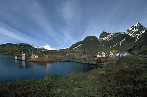
Whaling station Grytviken is in Cumberland East Bay

Cumberland East Bay is a bay forming the eastern arm of Cumberland Bay, South Georgia. It is entered between Sappho Point and Barff Point, where it is nearly 3 miles (4.8 km) wide, and extends 8 miles (13 km) in a southeast direction. This feature was surveyed by the Swedish Antarctic Expedition, 1901-04, who named it "South Bay". It was remapped during 1926-29 by DI personnel and renamed "East Cumberland Bay", which is more descriptive of its geographic position. The shortened form "East Bay" was simultaneously used. Following the SGS, 1951-52, the United Kingdom Antarctic Place-Names Committee (UK-APC) proposed that the name be altered to Cumberland East Bay and that all other names be rejected. This change brings together information about the whole of Cumberland Bay in one place in indexes, and will avoid confusion with East Bay in Prince Olav Harbour, South Georgia.

On 22 April–24 April, 1982, the British SBS attempted to cross Cumberland East Bay. They had landed in Hound Bay, and traversed the Sorling Valley, but were prevented from attacking Argentine positions by incessant ice and snow.[1]

Coordinates: 54°17′S 36°26′W / 54.283°S 36.433°W / -54.283; -36.433

References

  1. ^ Bicheno, Hugh (2006) Razor's Edge: The Unofficial History of the Falklands War. London. Weidenfield & Nicholson. ISBN 978-0-7538-2186-2

 This article incorporates public domain material from the United States Geological Survey document "Cumberland East Bay" (content from the Geographic Names Information System).


Wikimedia Foundation. 2010.

Игры ⚽ Поможем сделать НИР

Look at other dictionaries:

  • Cumberland East — was a provincial electoral district in Nova Scotia, Canada, that elected one member of the Nova Scotia House of Assembly. It existed from 1949 to 1993. Members of the Legislative Assembly This electoral district elected the following Members of… …   Wikipedia

  • Cumberland South —  Nova Scotia House of Assembly provincial electoral district Member of the Legislative Assembly …   Wikipedia

  • Cumberland West — was a provincial electoral district in Nova Scotia, Canada, that elected one member of the Nova Scotia House of Assembly. It existed from 1949 to 1993. v …   Wikipedia

  • Cumberland (provincial electoral district) — Cumberland was a provincial electoral district in Nova Scotia, Canada, that elected one member of the Nova Scotia House of Assembly. It existed from 1867 to 1949. v …   Wikipedia

  • Cumberland North — For the United Kingdom parliamentary constituency, see North Cumberland (UK Parliament constituency). Cumberland North  Nova Scotia House of Assembly provincial electoral district …   Wikipedia

  • Cumberland Centre — For the Census Designated Place in Maine, see Cumberland Center, Maine. Cumberland Centre was a provincial electoral district in Nova Scotia, Canada, that elected one member of the Nova Scotia House of Assembly. It existed from 1949 to 1993.… …   Wikipedia

  • Cumberland Gap National Historical Park — IUCN Category V (Protected Landscape/Seascape) Fog forming over the gap …   Wikipedia

  • Cumberland Bay State Park — is located in the Town of Plattsburgh in Clinton County, New York, on the Cumberland Head peninsula. The park is adjacent to Lake Champlain. The park offers a beach, picnic tables, a playground, and playing fields, recreation programs, a… …   Wikipedia

  • Cumberland Head, New York —   CDP   …   Wikipedia

  • Cumberland Mountain State Park — Byrd Creek Dam Type Tennessee State Park Location Cumberland County, Tennessee C …   Wikipedia

Share the article and excerpts

Direct link
Do a right-click on the link above
and select “Copy Link”