- Marramarra Parish, Cumberland
-
Marramarra
New South Wales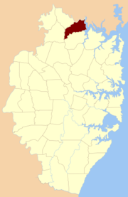
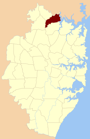
Location of the parish within CumberlandEstablished: 1835 Hundred (former): Dundas County: Cumberland LGA: Hornsby Shire Lands administrative divisions around Marramarra Frederick Northumberland Northumberland Maroota Marramarra Northumberland Maroota Berowra Cowan Marramarra Parish, Cumberland is one of the 57 parishes of Cumberland County, New South Wales, a cadastral unit for use on land titles.
The first landholding in the Parish of Marramarra was of 6 acres (24,000 m2) on the northern side of Marramarra Creek below Mount Blake. It was purchased by John Blake for One Pound Ten Shillings Sterling on June 6, 1835. The land had been advertised for sale by auction in an advertisement dated December 13, 1834.
Coordinates: 33°29′54″S 151°17′04″E / 33.49833°S 151.28444°E
References
Categories:- Parishes of Cumberland County
- Sydney geography stubs
Wikimedia Foundation. 2010.