Nuquí

Nuquí
Nuquí
—  Municipality and town  —
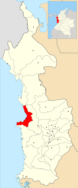
Location of the municipality and town of Nuquí in the Chocó Department of Colombia.
Country  Colombia
Department Chocó Department
Time zone Colombia Standard Time (UTC-5)


Nuquí is a municipality and town in the Chocó Department, Colombia.

Coordinates: 5°43′N 77°16′W / 5.717°N 77.267°W / 5.717; -77.267


Wikimedia Foundation. 2010.

Игры ⚽ Поможем написать реферат

Look at other dictionaries:

  • Nuquí — Bandera …   Wikipedia Español

  • Nuquí — 5°43′N 77°16′W / 5.717, 77.267 …   Wikipédia en Français

  • Nuqui — Lage von Nuquí Nuquí ist ein kleines Dorf mit etwa 3000 Einwohner an der Pazifikküste im Nordwesten Kolumbiens. Das Dorf liegt im Departamento de Chocó. Nuquí mit seinen einsamen Stränden ist nur mit dem Flugzeug via Quibdó oder Medellin bzw. mit …   Deutsch Wikipedia

  • Nuquí — Lage von Nuquí Nuquí ist ein kleines Dorf mit etwa 3000 Einwohnern an der Pazifikküste im Nordwesten Kolumbiens. Das Dorf liegt im Departamento de Chocó. Nuquí mit seinen einsamen Stränden ist nur mit dem Flugzeug via Quibdó oder Medellin bzw.… …   Deutsch Wikipedia

  • Nuqui — Original name in latin Nuqu Name in other language Nugui, Nugul, Nuqui, Nuqu State code CO Continent/City America/Bogota longitude 5.7125 latitude 77.27083 altitude 9 Population 2741 Date 2012 01 19 …   Cities with a population over 1000 database

  • Nuqui — Admin ASC 2 Code Orig. name Nuquí Country and Admin Code CO.11.3673691 CO …   World countries Adminstrative division ASC I-II

  • Chocó — Este artículo o sección necesita una revisión de ortografía y gramática. Puedes colaborar editándolo (lee aquí sugerencias para mejorar tu ortografía). Cuando se haya corregido, borra este aviso por favor. Para otros usos de este término, véase …   Wikipedia Español

  • Olaya Herrera Airport — Infobox Airport name = Olaya Herrera Airport nativename = Aeropuerto Olaya Herrera nativename a = nativename r = image width = caption = IATA = EOH ICAO = SKMD type = Commercial owner = operator = AirPlan (Sociedad Operadora de Aeropuertos Centro …   Wikipedia

  • El Caraño Airport — Infobox Airport name = El Caraño Airport nativename = Aeropuerto El Caraño IATA = UIB ICAO = SKUI type = Public owner = operator = city served = location = Quibdó, Colombia elevation f = 204 elevation m = 62 coordinates =… …   Wikipedia

  • Parque Nacional Natural Utria — Parque Nacional Natural Utría Mangroven in der Ensenada de Utría …   Deutsch Wikipedia

Share the article and excerpts

Direct link
Do a right-click on the link above
and select “Copy Link”