- Chera, Valencia
-
Chera — Municipality — 
Coat of armsLocation in Spain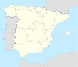
 Chera
CheraCoordinates: 39°35′29″N 0°58′32″W / 39.59139°N 0.97556°WCoordinates: 39°35′29″N 0°58′32″W / 39.59139°N 0.97556°W Country  Spain
SpainAutonomous community  Valencian Community
Province Valencia Comarca Requena-Utiel Judicial district Requena Government - Alcalde Alejandro Portero Igual PSOE Area - Total 54.5 km2 (21 sq mi) Elevation 600 m (1,969 ft) Population (2007) - Total 664 - Density 12.2/km2 (31.6/sq mi) Demonym cherano/a Time zone CET (UTC+1) - Summer (DST) CEST (UTC+2) Postal code 46350 Official language(s) Spanish Website Official website Chera (Valencian: Xera) is a municipality in the comarca of Requena-Utiel in the Valencian Community, Spain.
Geographically and historically Chera was part of the Serrans comarca. Nowadays, according to the current administrative division pattern of the Valencian Community, Chera is officially part of the Requena-Utiel comarca.
See also
- Sierra de Utiel
Municipalities of Requena-Utiel Camporrobles · Caudete de las Fuentes · Chera · Fuenterrobles · Requena · Sinarcas · Utiel · Venta del Moro · Villargordo del Cabriel Categories:
- Municipalities in Valencia
- Requena-Utiel
- Populated places in Valencia
- Valencian Community geography stubs


Wikimedia Foundation. 2010.