- Salinas de Garcí Mendoza
Infobox Settlement
official_name = PAGENAME
other_name =
native_name =
nickname =
settlement_type =
motto =
imagesize = 240px
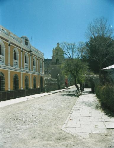
image_caption = Municipal Building and Church at the Plaza de Arma
flag_size =
image_
seal_size =
image_shield =
shield_size =
image_blank_emblem =
blank_emblem_type =
blank_emblem_size =
mapsize =
map_caption =
mapsize1 =
map_caption1 =
image_dot_
dot_mapsize =
dot_map_caption =
dot_x = |dot_y =
pushpin_
pushpin_label_position =bottom
pushpin_map_caption =Location of PAGENAME town in Bolivia
subdivision_type = Country
subdivision_name =
subdivision_type1 = Department
subdivision_name1 =
subdivision_type2 = Province
subdivision_name2 =Ladislao Cabrera Province
subdivision_type3 =
subdivision_name3 =
subdivision_type4 =
subdivision_name4 =
government_footnotes =
government_type =
leader_title =
leader_name =
leader_title1 =
leader_name1 =
leader_title2 =
leader_name2 =
leader_title3 =
leader_name3 =
leader_title4 =
leader_name4 =
established_title =
established_date =
established_title2 =
established_date2 =
established_title3 =
established_date3 =
area_magnitude =
unit_pref =Imperial
area_footnotes =
area_total_km2 =
area_land_km2 =
area_water_km2 =
area_total_sq_mi =
area_land_sq_mi =
area_water_sq_mi =
area_water_percent =
area_urban_km2 =
area_urban_sq_mi =
area_metro_km2 =
area_metro_sq_mi =
area_blank1_title =
area_blank1_km2 =
area_blank1_sq_mi =
population_as_of =2005
population_footnotes =
population_note =
population_total =
population_density_km2 =
population_density_sq_mi =
population_metro =
population_density_metro_km2 =
population_density_metro_sq_mi =
population_urban =
population_density_urban_km2 =
population_density_urban_sq_mi =
population_blank1_title =Ethnicities
population_blank1 =
population_blank2_title =Religions
population_blank2 =
population_density_blank1_km2 =
population_density_blank1_sq_mi =
timezone =
utc_offset =
timezone_DST =
utc_offset_DST =
latd=19 |latm=38 |lats=15 |latNS=S
longd=67 |longm=40 |longs=31 |longEW=W
elevation_footnotes =
elevation_m = 3732
elevation_ft =
postal_code_type =
postal_code =
area_code =
blank_name =
blank_info =
blank1_name =
blank1_info =
website =
footnotes =Salinas de Garcí Mendoza (formerly: Salinas de Thunapa) is a town in the
Bolivia nOruro Department .Salinas de Garcí Mendoza is the administrative center of
Ladislao Cabrera Province and is located 280 km south-west ofOruro , the department capital. It is situated at an altitude of 3.732 m at "Cerro Caricha" (4227 m), 20 km north of thestratovolcano Tunupa . 20 km north-west of Salinas de Garcí Mendoza is theSalar de Coipasa salt lake , 15 km in south-eastern direction isSalar de Uyuni , the world's largest salt pan. Salinas de Garcí Mendoza is endpoint of the road fromChuquichamba viaAndamarca and Aroma to Salinas de Garcí Mendoza.Salinas de Garcí Mendoza is bearing the title "Capital of Quinoa", because of the intensive cultivation of the
quinoa crop in this area.External links
* [http://www.aguabolivia.org/situacionaguaX/Riego/mapas/oruro/lcabrera.htm Map of province]
Wikimedia Foundation. 2010.

