- Fiľakovo
Geobox | Settlement
name = Fiľakovo
other_name = Fülek
category = Town
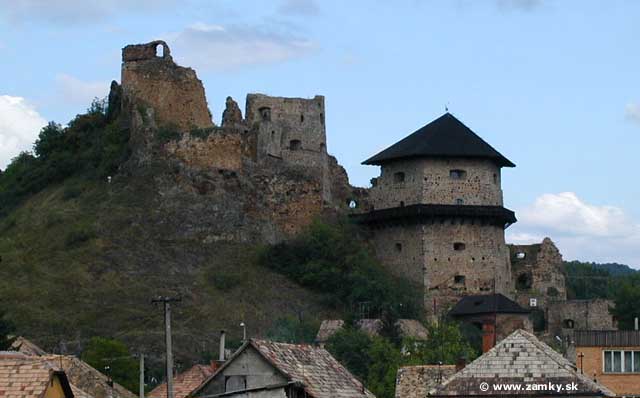
image_caption = Fiľakovo Castle
symbol =
etymology =
official_name =
motto =
nickname =
country = Slovakia
country_
state =
region = Banská Bystrica
district = Lučenec
commune =
municipality =
part =
river =
location =
elevation = 192
lat_d = 48
lat_m = 16
lat_s = 06
lat_NS = N
long_d = 19
long_m = 49
long_s = 29
long_EW = E
coordinates_type = region:SK_type:city
highest =
highest_elevation =
highest_lat_d =
highest_long_d =
lowest =
lowest_elevation =
lowest_lat_d =
lowest_long_d =
area = 16.18
area_round = 2
population = 10362
population_date = 2005-12-31
population_density = auto
established = 1242
established_type = First mentioned
mayor =
timezone =
timezone_DST =
postal_code = 98601
area_code = +421-47
code = LC
code_type = Car plate
free =

map_background = Slovakia - background map.png
map_locator = Slovakia
map1 = Banská Bystrica Region - outline map.svg
map1_background = Banská Bystrica Region - background map.png
map1_locator = Banská Bystrica Region
commons = Fiľakovo
statistics = [http://www.statistics.sk/mosmis/eng/prvav2.jsp?txtUroven430606&lstObec511391&Okruhzaklad MOŠ/MIS]
website = [http://www.filakovo.sk/index_uk.htm www.filakovo.sk]
footnotes =Fiľakovo ( _hu. Fülek, _de. Fülleck) is a town in the
Banská Bystrica Region of south-centralSlovakia . Historically it was part of theNógrád ("Novohrad") region.Geography
It is located in the
Cerová vrchovina mountains, in the valley of the "Belina" river, located around 20 km from the Hungarian city ofSalgótarján , 85 km fromBanská Bystrica , and around 220 km fromBratislava .History
The first written record of the town, along with the
Fiľakovo Castle is from1242 , where the castle withstood the Mongol invasions. It is mentioned in 1246 as "Filek". In 1423 the town received municipal privileges. In 1553 the town with castle fell to the Turks and was seat of asanjak until 1593, when it was reconquered by the Imperial troops. However, it fell once more to the Turks in 1669 and the town along with the castle was burned down in 1682 by troops ofImre Thököly . After theTreaty of Trianon in 1920 the town came under the rule ofCzechoslovakia . It belonged to Hungary again in years 1938–1945 after theFirst Vienna Award .Demographics
According to the 2001 census, ethnic groups included 64.40% Hungarians, 30.19% Slovaks, and 4.03% Roma. The religion make-up was as follows: 77.52% Roman Catholic, 11.82% without denomination, 3.21% not specified and others.cite web | title = Municipal Statistics | publisher = Statistical Office of the Slovak republic | date = | url = http://www.statistics.sk/mosmis/eng/run.html | accessdate = 2007-09-29]
People
*
Kovács Péter Garp , graphic, art, photographer
*Sándor Büchler , rabbi, historian
*Frank Lowy , Australian businessman
* Allan Vilhan alias Cargo CultReferences
External links
* [http://www.filakovo.sk/index_uk.htm Fiľakovo website]


Wikimedia Foundation. 2010.