- Dairsie
-
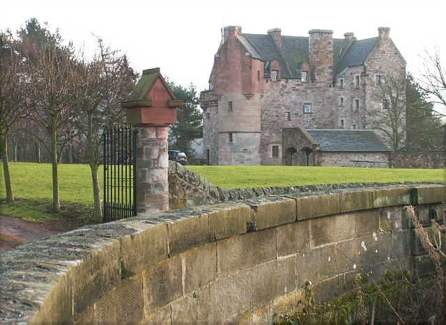
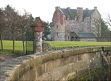 Dairsie Castle
Dairsie, or Osnaburgh, is a village in north-east Fife, Scotland. It is 3 miles (4.8 km) south-southwest of Leuchars Junction, and 3 miles (4.8 km) east-northeast of Cupar on the A91 Stirling to St Andrews road. The village grew out of two smaller settlements (called Dairsiemuir and Osnaburgh), and developed principally around the industry of weaving. Since the late twentieth century it has become a dormitory settlement for nearby towns.
The village may have derived its name of Osnaburgh from weaving osnaburg, a coarse linen or cotton, originally imported from Osnabrück in Germany.
Historic buildings
Dairsie Bridge, 1 mile (1.6 km) south of the village, dates from the early sixteenth century, although it has been modified since.[1] Nearby Dairsie Castle (now restored) dates from the early seventeenth century, and was briefly the residence of John Spottiswoode (1565-1639), Archbishop of St Andrews.[2] King James VI stayed at Dairsie Castle following his escape from the Raid of Ruthven in June 1583. St Mary's Church was built by Archbishop Spottiswoode in 1621.[3] The church is some distance from the village and ceased to be used for worship in 1966.[4] It is now in private hands, and the parish worshippers use the former St Leonard's Church in the village. The congregation is united with St John's Church in Cupar.
References
- ^ "Dairsie Bridge". CANMORE. Royal Commission on the Ancient and Historical Monuments of Scotland. http://canmore.rcahms.gov.uk/en/site/32943/details/dairsie+bridge/. Retrieved 2010-06-04.
- ^ "Dairsie Castle". CANMORE. Royal Commission on the Ancient and Historical Monuments of Scotland. http://canmore.rcahms.gov.uk/en/site/32942/details/dairsie+castle/. Retrieved 2010-06-04.
- ^ "Dairsie Old Church". CANMORE. Royal Commission on the Ancient and Historical Monuments of Scotland. http://canmore.rcahms.gov.uk/en/site/32904/details/dairsie+old+church/. Retrieved 2010-06-04.
- ^ "Dairsie Old Parish Church". Gazetteer for Scotland. http://www.scottish-places.info/features/featurefirst11250.html. Retrieved 4 June 2010.
Coordinates: 56°20′48.38″N 2°56′44.79″W / 56.3467722°N 2.945775°W
Categories:- Villages in Fife
- Fife geography stubs
Wikimedia Foundation. 2010.