- Stalowa Wola County
Infobox Settlement
name = Stalowa Wola County
native_name = Powiat stalowowolski
settlement_type =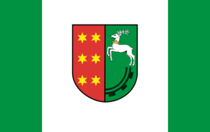
image_shield = POL powiat stalowowolski COA.svg
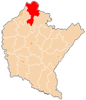
map_caption = Location within the voivodeship
subdivision_type = Country
subdivision_name = POL
subdivision_type1 = Voivodeship
subdivision_name1 = Subcarpathian
area_total_km2 = 832.92
population_total = 109170
population_as_of = 2006
population_density_km2 = auto
population_urban = 65818
population_blank1_title = Rural
population_blank1 = 43352
coor_type = Stalowa Wola
latd = 50
latm = 35
lats =
latNS = N
longd = 22
longm = 3
longs =
longEW = E
seat =Stalowa Wola
parts_type =Gmina s
parts = Total 6 (incl. 1 urban)
p1 =Stalowa Wola
p2 =Gmina Bojanów
p3 =Gmina Pysznica
p4 =Gmina Radomyśl nad Sanem
p5 =Gmina Zaklików
p6 =Gmina Zaleszany
blank_name = Car plates
blank_info = RST
website = http://www.stalowowolski.pl/ __NOTOC__Stalowa Wola County ( _pl. powiat stalowowolski) is a unit of territorial administration and local government (powiat ) inSubcarpathian Voivodeship , south-easternPoland . It was created onJanuary 1 ,1999 as a result of the Local Government Reorganization Act of 1998. Its administrative seat and only town isStalowa Wola , which lies convert|62|km|mi|0 north of the regional capitalRzeszów .The county covers an area of convert|832.92|km2|sqmi|1. As of 2006 its total population is 109,170, out of which the population of Stalowa Wola is 65,818 and the rural population is 43,352.
Neighbouring counties
Stalowa Wola County is bordered by
Kraśnik County to the north,Janów Lubelski County to the east,Nisko County to the south-east,Kolbuszowa County to the south, andTarnobrzeg County andSandomierz County to the west.Administrative division
The county is subdivided into six
gmina s (one urban and five rural). These are listed in the following table, in descending order of population.References
* [http://www.stat.gov.pl/gus/45_655_PLK_HTML.htm Polish official population figures 2006]


Wikimedia Foundation. 2010.