Sabine Pass Light

Sabine Pass Light

Infobox Lighthouse


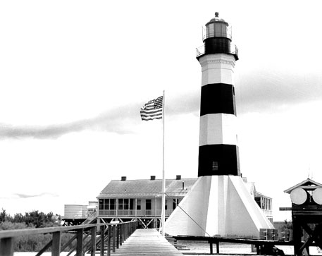
caption = Sabine Pass Light
location = Cameron Parish, Louisiana
coordinates = coord|29|43|04|N|93|51|00|W|region:US_type:landmark
yearlit = 1857
automated =
yeardeactivated = 1952
foundation = Brick buttresses / shellcrete
construction = Brick
shape = Octagon with 8 buttresses which gives it a 'rocket ship' appearance.
height = 85 feet
lens = Third order, Fresnel lens
range =
characteristic = White, flashed every 90 seconds

The Sabine Pass Light, one of only three built in the United States of similar design, went into operation in 1857. It remained lit for 95 years with the exception of a brief period during the Civil War when it was temporarily shut down. The light was permanently extinguished by the Coast Guard in 1952 when modern technology made it obsolete. The wharfs, keeper's house and wooden outbuilding have all been destroyed by marsh fire. The lighthouse has since been entered into the National Register of Historic Places, reference #81000290. The lighthouse is located on the Louisiana side of the Sabine River across from the community of Sabine Pass, Texas.

A restoration effort is being made by the Cameron Preservation Society.

External links

* [http://www.sabinepasslighthouse.org Lighthouse Website]
* [http://www.cr.nps.gov/maritime/light/sabineps.htm NPS - Historic Light Stations]
* [http://www.lighthousefriends.com/light.asp?ID=151 Sabine Pass article at Lighthouse friends]


Wikimedia Foundation. 2010.

Игры ⚽ Нужен реферат?

Look at other dictionaries:

  • Sabine River (Texas-Louisiana) — The Sabine River (pronEng|səˈbiːn) is a river, 555 miles (893 km) long, in the U.S. states of Texas and Louisiana. In its lower course, it forms part of the boundary between the two states and empties into the Gulf of Mexico. The river formed… …   Wikipedia

  • New Canal Light — The 1890/1901 structure. Location New Orleans, Louisiana Year first constructed 1838 Year first lit 1890 (last lighthouse) 2005 (current pole light) Automated Yes Deactivated …   Wikipedia

  • Chandeleur Island Light — 1971 Location Chandeleur Islands, Gulf of Mexico, Louisiana Year first constructed 1848 Year first lit 1896 (most recent tower) Automated 1951? Deactivat …   Wikipedia

  • Río Sabine — Saltar a navegación, búsqueda Para el río mexicano de parecido nombre, véase Río Sabinas. Río Sabine (Sabine River) …   Wikipedia Español

  • USS Morning Light (1853) — was a sailing ship acquired by the Union Navy during the American Civil War. She was used by the Navy to patrol navigable waterways of the Confederacy to prevent the South from trading with other countries. Morning Light , an 8 gun ship, was… …   Wikipedia

  • Chicago Mercantile Independent Battery Light Artillery — Active August 29, 1862 to July 10, 1865 Country United States Allegiance Union Branch Artillery …   Wikipedia

  • Lighthouses in the United States — This United States has hundreds of lights as well as light towers, range lights, and pier head lights. Michigan has the most lights of any state with over 130. See also: Lightvessels in the United States, lightvessel, List of lighthouses and… …   Wikipedia

  • Texas in the American Civil War — Confederate States in the American Civil War South Carolina Mississippi Florida Alabama …   Wikipedia

  • texas — /tek seuhs/, n. U.S. Naut. 1. a deckhouse on a texas deck for the accommodation of officers. 2. See texas deck. [1855 60; after TEXAS, from the fact that the officers accommodation was the most spacious on the Mississippi steamboats, on which… …   Universalium

  • Texas — Texan, Texian /tek see euhn/, adj., n. /tek seuhs/, n. a state in the S United States. 14,228,383; 267,339 sq. mi. (692,410 sq. km). Cap.: Austin. Abbr.: Tex., TX (for use with zip code). * * * I State (pop., 2000: 20,851,820), southwestern U.S.… …   Universalium

Share the article and excerpts

Direct link
Do a right-click on the link above
and select “Copy Link”