- Prospect Park (Minneapolis)
Infobox settlement
official_name = Prospect Park
nickname = The Angle, Tower Hill, Southeast
other_name = East Minneapolis
settlement_type = Neighborhood
motto = The International Neighborhood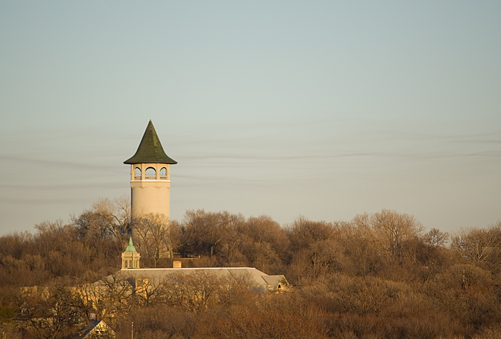
imagesize = 300px
image_caption = An autumn view of Prospect Park as seen from Stadium Village, with the conspicuous water tower.
image_blank_emblem =
mapsize = 200px
map_caption = Location of Prospect Park neighborhood within the U.S. city ofMinneapolis
subdivision_type = Country
subdivision_type1= State
subdivision_type2= County
subdivision_type3= City
subdivision_type4= Community
subdivision_name=United States
subdivision_name1=Minnesota
subdivision_name2= Hennepin
subdivision_name3=Minneapolis
subdivision_name4= University
established_title= Founded and Platted
established_date= 1885
founder = Louis Menage
named_for =Prospect Park (Brooklyn)
seat_type = City Council Ward
seat = 2
leader_title = Councilmember
leader_name =Cam Gordon
area_magnitude =
area_total =
TotalArea_sq_mi =
area_land =
LandArea_sq_mi =
area_water =
WaterArea_sq_mi =
area_water_percent =
area_urban =
UrbanArea_sq_mi =
area_metro =
MetroArea_sq_mi =
population_as_of = 2006
population_total = 8,734
population_density_sq_mi =
population_metro = 2,367,204
population_density_metro_km2 =
population_density_metro_sq_mi =
population_urban = 387,970
population_density_urban_km2 =
population_density_urban_sq_mi =
population_footnotes= [2000 Census: Census Tract 1049 Block 2, 3 and Tract 1050, Block 1, 2 (8,734 people) as referenced by PPERRIA's map.] cite web |title=Table 2: Population Estimates for the 100 Most Populous Metropolitan Statistical Areas Based on July 1, 2006 Population Estimates: April 1, 2000 to July 1, 2006 |publisher=U.S. Census Bureau |url=http://www.census.gov/Press-Release/www/releases/archives/cb07-51tbl2.pdf | format = PDF | date =2007-04-05 |accessdate=2007-04-16]
timezone= CST
utc_offset= -6
timezone_DST= CDT
utc_offset_DST= -5
latd= 44
latm= 58
lats= 08
latNS= N
longd= 93
longm= 12
longs= 45
longEW= W
elevation_m= 284
elevation_ft= 951
postal_code_type = Postal code
postal_code = 55414
area_code = 612
website = http://www.pperr.org/
footnotes = Prospect Park is a historicneighborhood within the University community of the U.S. city ofMinneapolis, Minnesota . The area is bounded by theMississippi River to the south, the City ofSaint Paul, Minnesota to the east, theBurlington Northern railroad yard to the north, and the Stadium Village commercial district of theUniversity of Minnesota to the west. The neighborhood is composed of several districts which include the East River Road area.An urban-village once served by streetcar, Prospect Park is now a combination of multiple districts and uses. Families live in single-family homes on "Tower Hill" while University students reside in apartment housing in the western districts. Estate homes of the early to mid 20th century line East River Road. The "SouthEast Industrial Area" (SEMI) in the north contains light manufacturing, rail yards and remnant grain silos. University Avenue houses a mix of retail and restaurant businesses from the Stadium Village area.
History
In 1874, real-estate tycoon Louis Menage (b. 1850) began plotting new subdivisions along Minneapolis' southern boundaries. [cite web|url=http://www.rakemag.com/reporting/features/erased-memory|title=Erased from Memory|author=Richard Broderick|date=2005-05-20|publisher=Rake Magazine|accessdate=2008-09-23] Menage petitioned the City Council to accept his Prospect Park plats in 1884. Construction lasted into the 1910s as topography and geographic isolation made building difficult.cite web|url=http://www.pperr.org/about/pdfs/HistDistSurveyReport.pdf|title=Prospect Park, Minneapolis: An Historical Survey|author=Prepared by Marjorie Pearson, Ph.D., Senior Historian|publisher=Hess, Roise and Company|date=October 2001|accessdate=2008-10-06] Houses were designed in the popular architectural styles of the period, especially the Queen Anne and the Colonial Revival styles. The Minneapolis Board of Education constructed the Sidney Pratt Elementary School in 1898.cite web| last = Kahn| first = Bill| title = Sidney Pratt School Centennial| publisher = Prospect Park East River Road neighborhood of Minneapolis| date = 1998| url = http://www.pperr.org/comm/pratt-centennial1998.html| accessdate =2008-10-07]
Thomas Lowry 's interurban commuter train serviced the neighborhood with its stop at Malcolm Avenue until eventually the intercity line between Saint Paul and Minneapolis along University Avenue was opened. The Franklin Avenue bridge also eventually carried a line.Geography
The site of the Prospect Park "Witch's Hat" Water Tower, constructed in 1913, is often cited as the city's highest point [cite web| publisher= Minnesota Historical Society| title= Minnesota Preservation Planner IX (2)| date= Spring 1998| url= http://www.mnhs.org/about/publications/planner/Spring1998.pdf| format = PDF | accessdate= 2007-03-21 and cite web| title= email| date= June 10, 2001| author= Bonham, Tim| url= http://mapnp.geeks.org/pipermail/mpls/2001-June/003374.html| accessdate= 2007-01-12 and cite web| publisher= U.S. Department of the Interior — U.S. Geological Survey| title= Elevations and Distances in the United States| url= http://erg.usgs.gov/isb/pubs/booklets/elvadist/elvadist.html| date= April 29, 2005| accessdate= 2007-04-11] and a placard in Deming Heights Park denotes the highest elevation at convert|951|ft|2, but a spot at convert|974|ft|2 in or near Waite Park in Northeast Minneapolis is corroborated by Google Earth as the highest ground. The tower, designed by Frederick Cappelen, is listed on the
National Register of Historic Places .Demographics
The neighborhood is demographically diverse. Tower Hill extending south to the river contains families and retired empty-nesters. The Glendale Housing project southeast of 27th Avenue SE and University Avenue SE contains 700 families with the average household income slightly above $9,000 and 32% of residents living at or below the poverty level. [cite web|url=http://www.clpha.org/page.cfm?pageID=289|title=Modernization in Minneapolis Glendale Family Development: Early Childhood Family Development Center|author=Council of Large Public Housing Authorities|date=October 2004|accessdate=2008-10-07] Both areas contain children. On the former industrial areas of the west and north are newer student housing apartment buildings for both undergraduate and graduate students.
Government
Prospect Park is entirely within Minneapolis' Ward 2, currently represented by
Cam Gordon on theMinneapolis City Council .Arts and culture
The neighborhood has an annual "Ice Cream Social" on the first Friday after Memorial Day, a get-together for the neighborhood with food, music and other entertainment. It is the one time of year when the interior of the water tower is opened to the public, allowing for a panoramic view of Minneapolis from the top.
Near the south end of the neighborhood on Bedford Street is the
Malcolm Willey House , designed byFrank Lloyd Wright and named after a University administrator. The historic significance of the house played a large part in preventing its destruction whenInterstate 94 was built in the 1950s. The current goal of the neighborhood is to establish an "urban-village" feel — that is, a somewhat self-contained feel in the context of a larger city. Prospect Park also has a few surviving houses from the 19th century.The neighborhood is home to two community centers, Pratt Elementary School and Luxton Park.
Gallery
 AM-FM-TV studios on University Avenue. The sidewalk leading to the building lies precisely on the city line, as does the central leg of the tower.
 The_Witch
ee also
*
Neighborhoods of Minneapolis
*University community of MinneapolisReferences
External links
* [http://www.pperr.org/ Prospect Park East River Road neighborhood of Minneapolis]
* [http://www.readthebridge.info/ The Bridge newspaper]
* [http://prattschool.org/ Pratt Community School]
Wikimedia Foundation. 2010.