- Gulpen
Infobox Settlement
official_name = Gulpen nl icon Gulpe li icon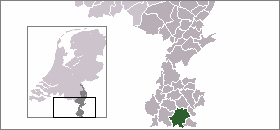
mapsize = 280pxriver
subdivision_type = Country
subdivision_name = flagicon|NEDNetherlands
subdivision_type1 = Province
subdivision_name1 =
population_as_of =1 January ,2005
settlement_type = Municipality
population_total = 3660
timezone = CET
utc_offset = +1
timezone_DST = CEST
utc_offset_DST = +2Gulpen is a village in the Dutch province of Limburg. It is approximately midway between the Dutch city of
Maastricht and the German city ofAachen .Gulpen was a separate municipality until 1999, when it merged with
Wittem . [Ad van der Meer and Onno Boonstra, "Repertorium van Nederlandse gemeenten", KNAW, 2006. [http://www.knaw.nl/cfdata/publicaties/detail.cfm?boeken__ordernr=20061061] ] The newly formed municipality is called Gulpen-Wittem.The town itself derives its name from the river Gulp, which runs straight through the centre of the village and characterises the townscape.
There is a Romanesque tower in the old cemetery, which dates from the 11th Century and is the only still existing part of a mediaeval village church. Considering its construction (its walls are up to 2 metres thick) and its location, it probably also served as defence tower, where the local villagers could go in case of danger.The former rectory, which leans against the tower, dates from 1732. It is now being let as luxurious group accommodation.
The current Neo-Romanesque St.Petrus church dates from 1924 and was designed by
Casper Franssen .A former monastery that was built in 1932 after a design by
Alphons Boosten is being used as town hall.The village is home to the
Gulpener Brewery .Every year in June, a walking tour of 70 kilometres is organised that is called the "
Nacht van Gulpen "(Night of Gulpen). A little over a thousand people participate in this event each year.References
External links
* [http://www.kuijsten.de/atlas/li/gulpen.html Map of the former municipality in 1868]
Wikimedia Foundation. 2010.