Cayo Batata

Cayo Batata

Infobox Islands
name = Cayo Batata


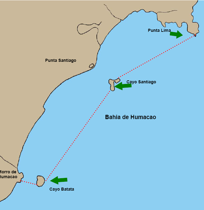
image caption = Humacao Estuary, with Cayo Batata in the southwest
image size =
locator
Location map|Puerto Rico|lat=18.115556|long=-65.771389
map_custom = yes
native name =
native name link =
nickname =
location =
coordinates = coord|18|6|56|N|65|46|17|W
archipelago =
total islands =
major islands =
area = convert|4679|m2|acre
length =
width =
coastline =
highest mount =
elevation = convert|12.1|m|ft
country = United States
country admin divisions title = Commonwealth
country admin divisions = flag|Puerto Rico
country admin divisions title 1 = Municipality
country admin divisions 1 = Humacao
country admin divisions title 2 =
country admin divisions 2 =
country capital =
country largest city =
country largest city population =
country leader title =
country leader name =
country 1 =
country 1 admin divisions title =
country 1 admin divisions =
country 1 capital city =
country 1 largest city =
country 1 largest city population =
country 1 leader title =
country 1 leader name =
country 2 =
country 2 admin divisions title =
country 2 admin divisions =
country 2 capital city =
country 2 largest city =
country 2 largest city population =
country 2 leader title =
country 2 leader name =
population = 0
population as of =
density = 0
ethnic groups =
additional info =

Cayo Batata is an uninhabited, grass-covered island, located at coord|18|06|56|N|65|46|17|W|, 600 m east of "Morro de Humacao", the closest mainland feature (which is immediately south of the mouth of Río Humacao), in Humacao, Puerto Rico. The island is rectangular with sides between 60 and 70 m in length. It is up to 12.1 m high. The area is 4,679 m², or 1.16 acres (Block 3060, Block Group 3, Census Tract 1805, Humacao Municipio, Puerto Rico). The island is part of "Río Abajo" barrio of Humacao.

A bare ledge, with five rocks and a reef, called "Caballo Blanco" (literally, White Horse, not to be confused with the islet of same name northwest of Vieques), awash and steep-to, is located 150 to 300 meters east and south of Cayo Batata.

Cayo Santiago (Monkey Island), the second island belonging to Humacao, is located 5.7 km to the northeast.

External links

* [http://www.nauticalcharts.noaa.gov/nsd/Cp5/CP5-35ed-Ch13_5.pdf nautical information]


Wikimedia Foundation. 2010.

Игры ⚽ Поможем решить контрольную работу

Look at other dictionaries:

  • Batata — is the Portuguese word for potato, from the Spanish patata . In some Arabic variants it is also the word for potato, even if potatis is more common. In Marathi, due to Portuguese influence, it also has the same meaning.It may also refer to: *… …   Wikipedia

  • Cayo Santiago — Infobox Islands name = Cayo Santiago image caption = Census Bureau map image size = locator Location map|Puerto Rico|lat=18.156389|long= 65.734167 map custom = yes native name = native name link = nickname = location = coordinates =… …   Wikipedia

  • List of amphibians and reptiles of Puerto Rico — This is a list of the amphibians and reptiles of the archipelago of Puerto Rico. The Puerto Rican archipelago consists of the main island of Puerto Rico, two island municipalities, Vieques and Culebra, one minor uninhabited island, Mona and… …   Wikipedia

  • List of islands of Puerto Rico — This is a list of islands off the coast of these municipalities of Puerto Rico. *Arecibo **Los Negritos **Roca Cocinera **Roca Resuello **Tres Hermanas *Barceloneta **Tres Hermanos*Bayamón **Isla San Juan*Cabo Rojo **Cayo Fanduca **Cayo Ratones… …   Wikipedia

  • List of islands in the Caribbean — This is a list of islands of the Caribbean region, organized by the political territory each island belongs to.Anguilla* Anguilla * Anguillita * Blowing Rock * Cove Cay * Crocus Cay * Deadman s Cay * Dog Island * East Cay * Little Island * Little …   Wikipedia

  • Antillas — Imagen por satélite de la parte oriental de las Islas Antillas y el Mar Caribe Localización geográfica / administrativa …   Wikipedia Español

  • Humacao (Puerto Rico) — Este artículo o sección necesita referencias que aparezcan en una publicación acreditada, como revistas especializadas, monografías, prensa diaria o páginas de Internet fidedignas. Puedes añadirlas así o avisar …   Wikipedia Español

  • Humacao, Puerto Rico — Infobox Settlement settlement type = subdivision type = Country subdivision name = United States subdivision type1 = Territory subdivision name1 = Puerto Rico subdivision type2 = subdivision name2 = timezone=AST utc offset= 4 timezone DST= utc… …   Wikipedia

  • Sphaerodactylus gaigeae — Sphaerodactylus gaigeae …   Wikipédia en Français

  • Sphaerodactylus macrolepis — Sphaerodactylus macrolepis …   Wikipédia en Français

Share the article and excerpts

Direct link
Do a right-click on the link above
and select “Copy Link”