Ma Wan Viaduct

Ma Wan Viaduct

Infobox Bridge
bridge_name= Ma Wan Viaduct


caption=
official_name=
carries= Route 8
crosses= Ma Wan
locale=
maint= Tsing Ma Management Limited, Hong Kong [http://www.gov.hk/en/about/abouthk/factsheets/docs/transport.pdf Hong Kong Factsheet: Transport] ]
id=
design= Concrete box girder
mainspan=
length= Convert|503|m|ft|0|abbr=on
width=
height=
load=
clearance=
below=
traffic=54,000last page]
begin=
complete=
open= 1997
closed=
toll=
map_cue=
map_

map_text=
map_width=
coordinates=
lat=
long=

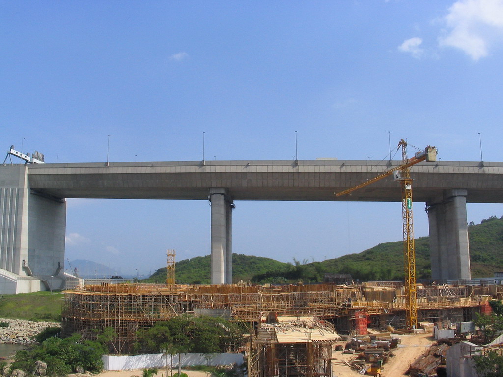
Ma Wan Viaduct is a viaduct built over Ma Wan, an island in the Hong Kong Special Administrative Region of the People's Republic of China. The viaduct connects the Tsing Ma Bridge and Kap Shui Mun Bridge, and is part of the Lantau Link (formerly known as Lantau Fixed Crossing) and Route 8. It was opened in 1997 and was built to privde access to the Hong Kong International Airport (Chek Lap Kok Airport) as part of the Airport Core Programme. [ [http://www.info.gov.hk/napco/p-llink.html Lantau Link (Hong Kong Airport Core Programme)] ]

It is Convert|503|m|ft|0|abbr=on long and has six spans. The Ma Wan Viaduct has the same cross section as the Tsing Ma and Kap Shui Mun Bridges: a dual three-lane carriageway on the upper deck and two tracks of railway and a two lanes of roadway in the enclosed lower deck. The lanes on the lower deck provide for maintenance and the diversion of traffic during high winds. The railway carries the Tung Chung and Airport Express lines of Hong Kong's Mass Transit Railway (MTR).

References

External links

* [http://www.info.gov.hk/napco/index-e.html Hong Kong Airport Core Programme]


Wikimedia Foundation. 2010.

Игры ⚽ Поможем написать курсовую

Look at other dictionaries:

  • Ma Wan — (zh t|t=馬灣) is an island of Hong Kong, located between Lantau Island and Tsing Yi Island. The island belongs to Tsuen Wan District. It has an area of 0.96 km². It is today more well known as Park Island (a private housing estate on the… …   Wikipedia

  • Nam Wan Tunnel — entrance. Traditional Chinese 南灣隧道 Simplified Chinese …   Wikipedia

  • List of streets and roads in Hong Kong — Here is a partial list of expressways, tunnels, bridges, roads, avenues, streets, crescents, squares and bazaars in Hong Kong.Routes Hong Kong s Transport Department is responsible for maintenance and control of highways and roadways. In 2004, a… …   Wikipedia

  • Lantau Link — The Lantau Link (zh tspcy|t=青嶼幹線|s=青屿干线|p=Qīngyǔ Gànxiàn|cy=ching1 yu4 gon3 sin3), formerly known as the Lantau Fixed Crossing, is a series of infrastructures linking Hong Kong International Airport to the urban areas in Hong Kong.The Lantau Link …   Wikipedia

  • Tsing Ma Bridge — at night Official name Tsing Ma Bridge Carries 6 lanes of roadway (upper) 2 MTR rail tracks, 2 lanes of roadway (lower) …   Wikipedia

  • Lantau Island — is highlighted in red. Geography Location South west Hong Kong Area 147.16 km2 (56.819 sq mi) Hi …   Wikipedia

  • Kap Shui Mun Bridge — Infobox Bridge bridge name= Kap Shui Mun Bridge 汲水門大橋 caption=Kap Shui Mun Bridge, viewed from Care Village official name= also known as= KSMB carries= 6 lanes of roadway (upper) 2 MTR rail lines, 2 lanes of roadway (lower) crosses= Kap Shui Mun… …   Wikipedia

  • Islands District — Infobox HK District official name = Islands map caption = Location in Hong Kong leader title = District Council Chairman leader name = Daniel Lam Wai keung, SBS, BBS, JP constituencies = 10 area note = area magnitude = area total = 175.03 area… …   Wikipedia

  • List of road-rail bridges — Road rail bridges are bridges shared by road and rail lines, as an economy measure compared to providing separate bridges. Road and rail may be provided with separate tracks, so that trains may operate at the same time as cars (eg the Sydney… …   Wikipedia

  • Island Eastern Corridor — Infobox road marker country= highway name=Island Eastern Corridor name notes=Part of Route 4 type= route= alternate name= maint= section= map custom=yes length mi= length round= length ref= length notes= established=1984 (Phase I) 1985 (Phase II) …   Wikipedia

Share the article and excerpts

Direct link
Do a right-click on the link above
and select “Copy Link”