- Patrickswell
Infobox Irish Place
name = Patrickswell
gaeilge = Tobar Phádraig
crest
motto =
map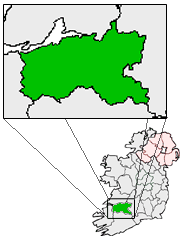
pin coords = left: 82px; top: 39px
north coord = 52.5952
west coord = 8.7122
irish grid = R518500
area =
county =County Limerick
population = 924
census yr = 2006
province =Munster
web =
|Patrickswell ("Tobar Phádraig" in Irish) is a small town in
County Limerick , Ireland. The name refers toSt. Patrick and there is a small hand pump/well in the main street; Microsoft mappoint and some other programs call the village St. Patrick's Well or St. Patrickswell. The town is located only 10 km from Limerick city, and as a result relies on the city and its suburbs for secondary schools, shops, banks and other facilities.The town has a
main street , with shops, garages, ATMs and a post office. There are severalhousing estate s ("Marian Park", "Lisheen Park","Belgard Grove" "Sycamore Heights" and "Laurel Park") off the main street and road toClarina . The latter road has strip development north from Patrickswell all the way to Clarina and the N69 road. As a dormitory town with only one major street, Patrickswell retains the appearance of a village, despite its population of over 3000. The town played a role in theBattle of Killmallock .The town is located near to the N20/N21 road, which until Patrickswell was bypassed in 2001, ran through the town centre. This road is now the R526 from west of the town to Limerick city. The town can be accessed at either end from the N20 junction for Limerick Racecourse, or the N20/N21 junction further west (where the R526 commences).
Transport
A railway line to
Adare andFoynes passes alongside the town to the south, although Patrickswell station is long closed. The station was at one time Patrickswell Junction, with direct Limerick–Cork trains diverging here from the route of trains bound for Foynes,Newcastle West andTralee . Freight trains from Limerick to/from Foynes ran until 1999, and technically the line is still open - though not passable all the way to Foynes (a bridge is in need of replacement). As of 2007 the last movement was a weedspray train in 2002. Passenger trains ceased in 1963 and the Cork direct line was closed soon after, then in the mid 1970s the Ballingrane–Tralee (North Kerry) line closed (see Irish railway history). Patrickswell railway station opened on12 July 1856 , closed for passenger traffic on4 February 1963 and finally closed altogether on2 December 1974 . [cite web | title=Patrickswell station | work=Railscot - Irish Railways | url=http://www.railscot.co.uk/Ireland/Irish_railways.pdf | accessdate=2007-11-22] Patrickswell Railway station is now in private ownership, it is home to Hutch Hollywood Engineers.Media
Despite the size, Patrickswell exchange is not DSL enabled. Some parts can get
Digiweb Metro Broadband on 10.5 GHz wireless.ee also
* List of towns and villages in Ireland
References
Wikimedia Foundation. 2010.