- Texas State Highway 354
Infobox TX State Highway
type=State
route=354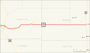
length_mi=21.354
length_ref=TxDOT|SH|354|accessdate=2008-03-12]
length_round=3
formed=1944
dir1=West
dir2=East
from=jct|state=TX|US|385 in Channing
junction=
to=jct|state=TX|US|87|US|287
previous_type=State
previous_route=353
next_type=State
next_route=355State Highway 354 or SH 354 is a state highway in the
Texas Panhandle . This route is a replacement of a portion of SH 5, which was replaced by U.S. Routes in 1944. This section was bypassed, and was renumbered to keep state highway status.Route description
SH 354 begins at an intersection with US 385 in the town of Channing. The highway is known as 7th Street in Channing and the road extends to the west of the US 385 intersection as FM 767. SH 354 heads to the east from this intersection through Hartley County. It passes over into Moore County before an intersection with FM 2202. The highway continues east to its eastern terminus at an intersection with a concurrent US 87 and US 287. The road continues east past this intersection as FM 1913.cite map|publisher=
Google Maps |title=Overview map of SH 354|accessdate=2008-03-12|url=http://maps.google.com/maps?f=d&hl=en&geocode=15925322321278484959,35.683750,-102.329640%3B2766757844823191585,35.690468,-101.965140&saddr=TX-354+%4035.683750,+-102.329640&daddr=FM-1913%2FTX-354+%4035.690468,+-101.965140&doflg=ptm&sll=35.682945,-102.14739&sspn=0.146684,0.374222&ie=UTF8&z=12]Junction list
References

Wikimedia Foundation. 2010.