- 11th Milestone
Infobox TT course
Name = 11th Milestone
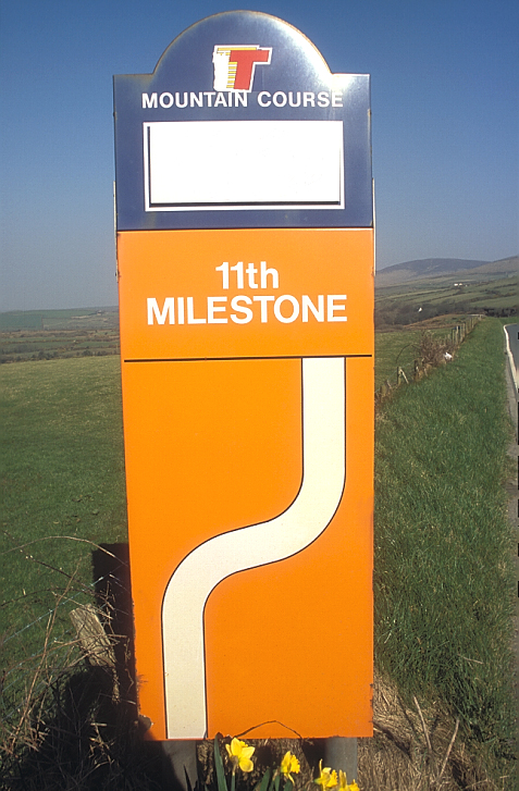
Caption = TT marker board for the 11th Milestone
Latitude = 54.245
Longitude = -4.596
OSgridref = SC309863
Parish = German
Distance = 11.3
Follows =Handley's Corner
Precedes =Cronk-y-Voddy 11th Milestone or "Drinkwater's Bend" [pp58 "Motocourse History of the Isle of Man Tourist Trophy" by Nick Harris] is a corner on the primary A3 road in the parish of Michael in the
Isle of Man . The distinctive S-bend corner is situated between the 11th and 12th milestone road marker for the Mountain Course used for theIsle of Man TT andManx Grand Prix Races.The S-bend corner was part of the
Highland Course andFour Inch Course used for theGordon Bennett Trial and Tourist Trophy automobile car races held in the Isle of Man between 1904 and 1911. Also the 11th Milestone was part of theSt. John's Short Course used between 1907 and 1910 and part of the Snaefell Mountain Course used since 1911 for the Isle of Man TT Races and Manx Grand Prix.The area is dominated by the Ballamenagh and Shoughlaige-e-Caine farmland. During the 1850's the
Castletown to Ramsey primary A3 Road was re-profiled between _gv. Cronk-y-Voddy andHandley's Corner . ["Manx Milestones" by Stuart Slack pp33 (1st Edition)(2003)The Manx Experience ISBN 1 873 120 58 3] This was to avoid marshland and steep inclines creating the distinctive S-bend known as "Drinkwater's Bend" afterBen Drinkwater who was killed at this point on the Mountain Course during the 1949 350ccJunior TT Race.The original stone 11th milestone was sited at the corner café at
Glen Helen . An iron milestone ["Manx Milestones" by Stuart Slack pp56-57 (1st Edition)(2003)The Manx Experience ISBN 1 873 120 58 3] from the 1860's from the period of James Garrow as Isle of Man Surveyor-General ["Isle of Man Examiner" dated 3rd May 1913] is now situated at the northerly end of 'Drinkwater's Bend' as the 13th Milestone on the primary A3 Castletown to Ramsey Road. [1870 Isle of Man Survey - Ordnance Survey Map Grid Ref 230872]The current site of the 11th marker post or "11th Milestone" road marker for the Snaefell Mountain Course has been placed at Cronk Bane Farmhouse on the Cronk-y-Voddy straight. The S-bend corner "Drinkwater's Bend" still retains the name of 11th Milestone due to the distinctive metal milestone.
The corner was subjected to road surface repair work and re-profiling during the winter of 2005/2006 by the Department of Transport.
ources
External links
* [http://www.iomtt.com/TT-2009/Circuit-Guide/Competitors/BlackDub-HandleysCorner.aspx Black Dub to Handleys Corner] with
Steve Hislop , 11 times TT winner
* [http://www.iomtt.com/TT-2009/Circuit-Guide/Spectators/11th%20Milestone%20to%20Rhencullen.aspx TT Spectator Guide Section 11th Milestone to Rhencullen]
* [http://www.iomtt.com/TT-2009/Circuit-Guide.aspx Map of course]
Wikimedia Foundation. 2010.