- Oregon Route 154
-
Oregon Route 154
Route information Maintained by ODOT Length: 5.74 mi (9.24 km) Existed: 2002 – present Major junctions South end:  OR 153 near Hopewell
North end:  OR 233 in Dayton
Highway system Oregon highways
Routes • Highways← OR 153OR 164  →
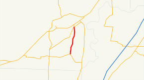
→Oregon Route 154 is an Oregon state highway running from OR 233 near Dayton to OR 153 near Hopewell. OR 154 is composed of most of the Lafayette Highway No. 154 (see Oregon highways and routes). It is 5.74 miles (9.24 km) long and runs north–south, entirely within Yamhill County.
OR 154 was established in 2002 as part of Oregon's project to assign route numbers to highways that previously were not assigned, and, as of November 2009, was unsigned.
Despite the name, the Lafayette Highway does not actually reach Lafayette. However, a Yamhill County maintained "Lafayette Highway" continues past OR 18 to enter the city of Lafayette. Also, Yamhill County signs the portion of Oregon Route 153 east of the junction with OR 154 as "Lafayette Highway," as well.
Contents
Route description
OR 154 begins at an intersection with OR 18 approximately one mile southwest of Dayton, several miles south of Lafayette. It heads south to an intersection with OR 153 near Hopewell, where it ends.
History
OR 154 was assigned to the undesignated part of the Lafayette Highway in 2002.
Major intersections
Milepost City Intersection 0.52 Dayton OR 233 6.26 Near Hopewell OR 153 OR 154 begins at milepost 0.52 because Oregon numbers mileposts along highways.
Related routes
References
- Oregon Department of Transportation, Descriptions of US and Oregon Routes, http://www.oregon.gov/ODOT/HWY/TRAFFIC/TEOS_Publications/PDF/Descriptions_of_US_and_Oregon_Routes.pdf, page 27.
- Oregon Department of Transportation, Lafayette Highway No. 154, ftp://ftp.odot.state.or.us/tdb/trandata/maps/slchart_pdfs_1980_to_2002/Hwy154_1997.pdf
- Oregon Department of Transportation, Digital Video Log, 2010 Season, reviewed 29 August 2011.
Categories:- State routes in Oregon
- Transportation in Yamhill County, Oregon


Wikimedia Foundation. 2010.