- CommunityViz
-

Developer(s) Orton Family Foundation and Placeways, LLC Stable release 4.1 / May 28, 2010 Operating system Windows Type ArcGIS extension License Proprietary Website www.communityviz.com
CommunityViz is the name of a group of extensions to ArcGIS Geographic Information System software. CommunityViz is an analysis tool used for, among other applications, urban planning, land use planning, geodesign, transportation planning and resource management applications. It also provides options for 3D visualization in the Scenario 3D and Scenario 360 plugins. CommunityViz also allows users to export their data to Google Earth and other KML/KMZ viewers such as ArcGIS Explorer. The software is produced in a partnership between the Orton Family Foundation and Placeways LLC. Placeways also offers professional consulting services utilizing CommunityViz for customized analysis, visualization, and public participation events.Contents
History
CommunityViz began as an idea in the late 1990s when Noel Fritzinger and his friend Lyman Orton, proprietor of the Vermont Country Store and long-term member of his town’s local planning board, first envisioned a software tool that would make the planning process more accessible to ordinary citizens. After forming the Orton Family Foundation, they recruited a consultant team to develop the idea. The initial team included The Environmental Simulation Center, ForeSite Consulting, PricewaterhouseCoopers, Multigen-Paradigm, and Green Mountain GeoGraphics. The first commercial version was released in late 2001 and included three components: Scenario Constructor for interactive analysis, SiteBuilder 3D (OEMed from MultiGen-Paradigm) for 3D visualization, and Policy Simulator for agent-based modeling of future outcomes resulting from present-day policy decisions. The price for the suite at that time was approximately $5000 USD.
By 2003 there was enough experience and research to guide a complete redevelopment that resulted in CommunityViz Version 2. The new version was built for the new architecture of ArcGIS 8.x.[1] It changed Scenario Constructor to Scenario 360 and gave it a new, intuitive interface. SiteBuilder 3D was updated, but Policy Simulator was dropped from the package. The new design quickly gained popularity.
In 2004, CommunityViz development and operations were spun off from the Foundation into a new company called Placeways LLC, and simultaneously the price of the software was greatly reduced.[2] With continuing guidance and financial support from the Foundation, Placeways continued with new research and development, introducing Version 3 and its “decision tool” architecture in the fall of 2005.
The current release of CommunityViz is Version 4.1, which now costs between $350 and $850.[3] Version 4.1 is compatible with ArcGIS 9.2 and up, including 10. The company also offers educational pricing.
Analysis Capabilities
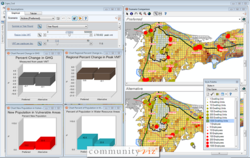
In CommunityViz Scenario 360, users can create their own analyses across multiple scenarios using custom formulas, indicators, and charts which all update dynamically in real time as the user makes changes on the map or to the calculations. Because CommunityViz is an extension to ArcGIS Desktop, users can bring in GIS data and use CommunityViz while maintaining access to all ArcGIS Desktop functionality. Data from other external models can be brought in as well.
Tools
CommunityViz contains additional analysis features including several for creating indicators, such as the Common Impacts Wizard which can produce up to 16 indicators, the Custom Impacts Wizard to aid in designing your own indicators, and the ability to freely design as many of your own formulas and indicators as you desire. Other tools include the Land Use Designer which allows you to paint desired land uses and analyze the effects, the Build-Out Wizard which calculates the development capacity for your land, a Suitability Wizard, and TimeScope which allows you to visualize change through time. There are also additional premium tools available which include the Optimizer, Allocator, and LandFrag Wizard.
Users
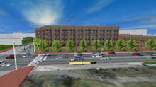 CommunityViz's Scenario 3D being used to plan a site development.
CommunityViz is used primarily for land-use planning and natural resource management, but because it allows its users to create custom analyses, it can be applied to almost any geographic decision-making process. The largest user groups comprise government planners (local, regional, and national), private planning and design firms, and universities. Most users are already somewhat familiar with GIS or have access to a GIS department.
3D Tools
Current 3D capabilities include:
- Automatically export to Google Earth and create scenes using SketchUp models.
- Create highly realistic, interactive 3D scenes using Scenario 3D with 3D models in common CAD and SketchUp formats (.KMZ, .3DS, and COLLADA interchange (.DAE)).
- Works as an extension to ArcGIS ArcScene.
Awards
At the 2011 Esri Business Partners Conference, Placeways received the Extension to ArcGIS Desktop award for CommunityViz.
Book
In 2011, The Planners Guide to CommunityViz: The Essential Tool for a New Generation of Planning, by Doug Walker and Tom Daniels, was published and made available for purchase through the APA Planners Press. The book, through visuals, examples, and case studies, demonstrates CommunityViz applications across many disciplines and the many ways it can be applied including for analysis, visualization, and public participation.
Common misspellings
"CommunityVis," "Community Viz," "communityviz," "Communitybiz" and "Communityviz" are some of the most common ways of misspelling the name. The correct spelling contains no spaces, a capital "V," and a "z." The abbreviations "CViz" and "CV" are sometimes used.
References
- ESRI (2004) What is ArcGIS? - White paper. [4] - (PDF download, 124 pages, 16 mb)
See also
External links
- CommunityViz web site
- Placeways web site
- The Orton Family Foundation web site
- Geodata Services, Inc. web site
Categories:- GIS software
- ArcGIS Extension


Wikimedia Foundation. 2010.