- Ross Island Bridge
Infobox_Bridge
bridge_name=Ross Island Bridge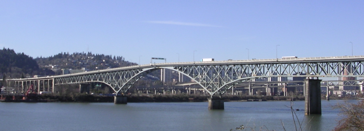
official_name=Ross Island Bridge
carries=US 26
crosses=Willamette River
locale=Portland, Oregon
maint=ODOT
design=Cantilever decktruss
length= 3,700 ft
mainspan=535 ft
open=1926
lat=45.50121
long=-122.66454The Ross Island Bridge is a cantilever truss bridge that spans the
Willamette River inPortland, Oregon . It carries U.S. Route 26 (Mount Hood Highway ) across the river between southwest and southeast Portland. Although it looks like adeck arch bridge , it is the only cantilever deck truss bridge inOregon . [cite web | publisher = Oregon Department of Transportation | | title = Willamette River (Ross Island) Bridge | format = Word | url = http://egov.oregon.gov/ODOT/HWY/GEOENVIRONMENTAL/docs/Historic_Bridge/Willamette_Ross_Island_Bridge.doc | accessdate = 2006-11-06 ]The bridge is named for its location close to Ross Island, an island in the Willamette River which measures about one-and-a-half by one miles. The bridge is about 800 feet (250 m) north of the island and does not connect with, nor does it provide access to Ross Island.
The bridge was part of the unprecedented period of bridge building in Portland during the 1920s. It was opened on
December 21 ,1926 at a cost of $1.9 million. The bridge was designed by famed engineerGustav Lindenthal . [cite book | first = Dwight A. | last= Smith | coauthors = Norman, James B.; Dykman, Pieter T. | title = Historic Highway Bridges of Oregon | publisher = Oregon Historical Society Press | date = 1989 | pages = 78 | id = ISBN 0-87595-205-4 ]There is a
pedestrian walkway on the north side of the bridge, with no barrier between the sidewalk and the westbound right lane.During the
Great Depression , the bank of the Willamette near the Ross Island Bridge became the site of aHooverville . [cite book | last= Wood | first= Sharon | title = The Portland Bridge Book | publisher =Oregon Historical Society | date = 2001| id= ISBN 0-87595-211-9 ]In 1976 ownership was transferred from Multnomah County to the
Oregon Department of Transportation . In 2000-2001 the bridge underwent a $12.5 million renovation in which the deck was replaced, the railings were replaced and upgraded, and the drainage system and lighting were improved. During this renovation,lead paint was discovered, causing some delays and cost overruns. [cite web| title = Bridge face-lift requires more cash, more time | first = Don | last = Hamilton | publisher =Portland Tribune | date =April 13 ,2001 | url = http://www.portlandtribune.com/news/story.php?story_id=2993 | accessdate = 2005-11-22]Approaches
West approach
The west end of the bridge has a full interchange with
Naito Parkway (Oregon Route 10 ,Pacific Highway West ), as well as access to and from Arthur Street, which carries US 26 towards Interstate 405. (Until around 2005, US 26 went north on Naito Parkway and through the south side of downtown Portland.) Access is also provided to and from the north end ofOregon Route 43 (Macadam Avenue -Oswego Highway ), which runs next to Interstate 5 asfrontage road s, and allows for access to and from I-5 via slip ramps and U-turns.The pedestrian walkway comes off the north side parallel to the ramp to Kelly Avenue (leading to Arthur Street), running to the intersection of Kelly Avenue and Porter Street.
East approach
At the east end of the bridge, US 26 becomes Powell Boulevard as it passes over
Oregon Route 99E (Pacific Highway East ). Route 99E is a high-speedarterial road , built to near-freeway standards; just to the north it passes over a railroad on the twinMartin Luther King, Jr. Viaduct and Grand Avenue Viaduct. There is a direct ramp from US 26 east to Route 99E south, but no northbound access. Likewise, there is access from Route 99E north to the bridge (via Woodward Street and 8th Avenue), but traffic from Route 99E south must exit at Mill Street, about 1/2 mile (1 km) to the north, and head down Division Street, 11th Avenue and Milwaukie Avenue to US 26. This same movement is done to reach US 26 east; US 26 west however has direct access to Route 99E north via 9th Avenue and Woodward Street. A fourth direct ramp runs from Route 99E north to US 26 east.The pedestrian walkway simply becomes the north sidewalk of Powell Boulevard, a major street.
ee also
*
List of crossings of the Willamette River References
External links
*
Library of Congress , [http://memory.loc.gov/cgi-bin/query/r?ammem/fsaall:@filreq(+@FIELD(SUBJ+@band(+Hooverville++Oregon+))+@field(COLLID+fsa)) photos of a Hooverville near the Ross Island Bridge]Crossings navbox
structure = Crossings
place =Willamette River
bridge = Ross Island Bridge
bridge signs =
upstream =Sellwood Bridge
upstream signs =
downstream =Marquam Bridge
downstream signs =
Wikimedia Foundation. 2010.