Brattlikollen (station)

Brattlikollen (station)

Infobox T-bane station
name = Brattlikollen
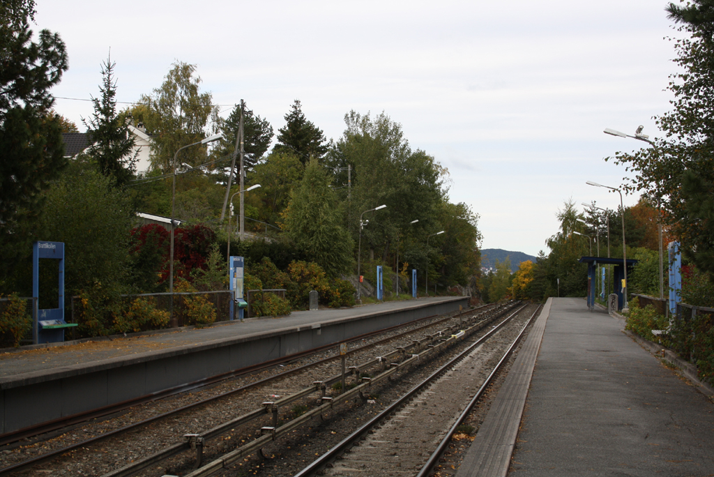


caption =
locale = Brattlikollen
municipality = Oslo
line = Lambertseterbanen
distance = 7.9 km
elevation = 165.5 m
coordinates = coord|59|53|12|N|10|48|2|E|display=title,inline|region:NO-03_scale:50000_type:railwaystation
start = 1966
type = At-grade
line1 =
line1a = yes
line2 =
line3 =
line4 = yes
line5 =
line6 =
train =
flytoget =
tram =
bus =|

Brattlikollen is a station on Lambertseterbanen (line 4 and during rush hour also Line 1) of the Oslo T-bane system. The station is between Ryen and Karlsrud, 7.8 km from Stortinget. The station was opened on May 22 1966. The station's architect was Edgar Smith Berentsen. [ [http://www.sporveien.no/templates/Page____766.aspx Subway stations in the east] ]

The station is on the south side of Brannfjell. The neighborhood around the station is mainly residential with a mixture of detached houses and apartment buildings. Access to the station is from the local road Sandstuveien which passes below the line immediately south of the station.

References


#
  • [http://kart.gulesider.no/kart/map.c?w=10.793143071912&ps=8&tool=zoom&n=59.8892736786725&companies=&s=59.8843627213275&e=10.808001928088&scrollX=0&scrollY=0&id=a_10000334825 Map of station area] (Gulesider.no)
  • Oslo T-bane next
    station = Brattlikollen
    line4 = yes
    west4 = Ryen
    east4 = Karlsrud
    westspan4 = 1
    eastspan4 = 1|


    Wikimedia Foundation. 2010.

    Игры ⚽ Нужно сделать НИР?

    Look at other dictionaries:

    • Karlsrud (station) — Infobox T bane station name = Karlsrud caption = Karlsrud in June 2006 locale = Lambertseter municipality = Oslo line = Lambertseterbanen distance = 8.6 km elevation = coordinates = coord|59|52|47|N|10|48|19|E|display=title,inline|region:NO 03… …   Wikipedia

    • Ryen (station) — Infobox T bane station name = Ryen caption = Ryen in June 2007 locale = Østensjø municipality = Oslo line = Lambertseterbanen distance = 6.7 km elevation = 124.0 m coordinates = coord|59|53|44|N|10|48|14|E|display=title,inline|region:NO 03… …   Wikipedia

    • Nationaltheatret (station) — For the mainline railway station underneath, see Nationaltheatret Station. Nationaltheatret Entrance Location Place Vika Municipality …   Wikipedia

    • Mortensrud (station) — Mortensrud Location Place Mortensrud, Søndre Nordstrand Municipality Oslo Coordinates …   Wikipedia

    • Nydalen (station) — For the railway station, see Nydalen Station. Nydalen Location Place Nydalen, Nordre Aker Municipality …   Wikipedia

    • Østhorn (station) — Østhorn Lo …   Wikipedia

    • Nordberg (station) — Nordberg Location …   Wikipedia

    • Montebello (station) — Montebello Location Place Montebello Municipality Oslo Coordinates …   Wikipedia

    • Majorstuen (station) — Majorstuen Two MX3000 at the station Location Place Majorstuen Municipality Oslo …   Wikipedia

    • Østerås (station) — Østerås MX3000 unloading at Østerås. Location Place Østerås Municipality Bærum Coordinates …   Wikipedia

    Share the article and excerpts

    Direct link
    Do a right-click on the link above
    and select “Copy Link”