- Danviksbro
-
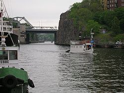
 Danviksbro.
 View from Hammarby Sjö with bridge in the background.
 Historical photo of the area. Roughly the same location and direction as the photo above.
Danviksbron or, alternatively, Danviksbro ("Danvik Bridge") is a bascule bridge in central Stockholm, Sweden, connecting the eastern end of Södermalm to the eastern municipality Nacka. Under the bridge, the canal Hammarbykanalen carries the water of Hammarby Sjö over to Saltsjön. The bridge, actually two separate bridges carries the railway Saltsjöbanan and a road.
For unknown reasons the location of the bridge, like many other places along the shores of Sweden and Norway, was named 'Danviken', meaning danernas vik, "The Bay of the Danes", and until the early 20th century most people called it Dannviken (short a, like Danmark is still pronounced) rather than, like is common today, Daanviken (long a).[1]
Contents
History
Since King Gustav Vasa (1496–1560) had the water level of the lake Hammarbysjön increased by 4.8 metres, the lake emptied into Saltsjön through a small rivulet overshadowed by a simple wooden bridge and the familiar silhouette of an old mill, and for many centuries Danviken remained mostly renowned for its hospital, Danviks hospital, which the king had moved from Riddarholmen near the city.[1][2]
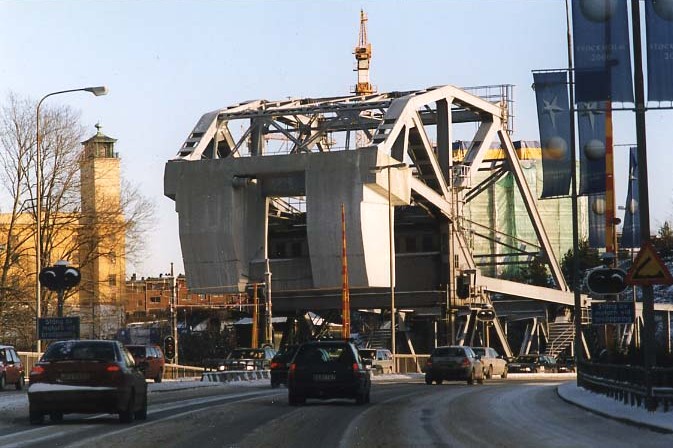
In 1922, a railway viaduct built in 1893 was demolished together with the old bridge, both replaced by a single leaf bascule bridge with its concrete counterweight hanging over the 14 metres wide roadway shared by trains and vehicles. On the eastern side of the canal a concrete viaduct connected to the bridge, and the bridge's load-carrying steel trusses left a horizontal clearance of 12,5 metres for the ships below.[2]
To deal with increasing post-WW2 traffic loads, the capacity of the bridge was increased in 1956 by adding a new bridge south of and parallel to the old, the two structures separated by less than a metre. The new bridge was 22,2 metres wide, of which 14 metres were used by vehicles, and 5 metres for bicycles and pedestrians, which effectively left the trains and bicyclists have the old bridge for themselves. A single leaf bascule bridge was chosen this time to, but this time having in mind that the canal was prospected to be widened, which would hopefully be done easily by adding more bridge to the present unaltered structure.[2]
By the 1970s traffic had increased enough again to motivate a redevelopment of the traffic system surrounding the bridge and the enlargement of the bridge itself. This was simply done 1973-1977 by replacing one of the open web girders for a steel girder underlying the deck, thus giving space for additional cantilevering roadways. [2]
Plans
There are plans to a new high double track tramway bridge, carrying the Saltsjöbanan, which will be redefined from railway to tramway. Rising cost estimates (now about 3 bn SEK) have delayed the construction start, which is now planned to be around 2012.
See also
References
- ^ a b "Södermalm". Stockholms gatunamn (2nd ed. ed.). Stockholm: Kommittén för Stockholmsforskning. 1992. pp. 223–225. ISBN 91-7031-042-4.
- ^ a b c d Dufwa, Arne (1985). "Broar och viadukter: Danviksbron". Stockholms tekniska historia: Trafik, broar, tunnelbanor, gator. Uppsala: Stockholms gatukontor and Kommittén för Stockholmsforskning. pp. 205–206. ISBN 91-37-08725-1.
External links
- webbkameror.se - Webcam at Danviksbron
- Stockholmskällan - Historical images of Danviksbron.
Coordinates: 59°18′49″N 18°06′17″E / 59.31361°N 18.10472°E
Categories:- Bridges in Stockholm
- Bridges completed in 1922
- Bridges completed in 1956
- Bascule bridges


Wikimedia Foundation. 2010.