- Nizhnyaya Tunguska River
-
Coordinates: 65°47′00″N 87°57′20″E / 65.7833333°N 87.95556°E
Nizhnyaya Tunguska (Нижняя Тунгуска) River  Lower Tunguska at summer of 2008.
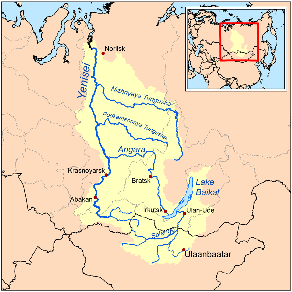
Tributaries - right Kochechum Cities Turukhansk, Tura, Erbogachen Source - location Central Siberian Plateau, Russia Mouth Yenisei river Length 2,989 km (1,857 mi) Basin 473,000 km2 (182,626 sq mi) Discharge for Yenisei river[1] - average 3,680 m3/s (129,958 cu ft/s) - max 112,000 m3/s (3,955,243 cu ft/s) - min 1 m3/s (35 cu ft/s)  Map of the Yenisei basin that shows the Nizhnyaya Tunguska river
Nizhnyaya Tunguska (Russian: Нижняя Тунгуска, Lower Tunguska) — is a river in Siberia, Russia, flows through the Irkutsk Oblast and the Krasnoyarsk Krai. The river is a right tributary of the Yenisei joining it at Turukhansk (see Siberian River Routes). Settlements on the river include Tura, Yukti and Simenga. The ice-free period on the Lower Tunguska starts in mid-June and ends in the first half of October.
Contents
Hydrography
The second largest right tributary of Yenisei joins it near town Turukhansk. According character of stream, constitution of river's valley and its shores it can be divided into two parts: the first one starts at the source of the river and continues down to village Preobrazhenskoye and the second section of the river lies downstream of this village in a canyon-like relief.[2]
Upper stream
The first part of Lower Tunguska has length 580 km and occupies wide valley with flat slopes which is formed basically of sand and clay deposits. The speed of flow at rafts reaches 0.4-0.6 m/sec and drops significantly at the stretches of river's channel.
This section of river has meandering channel approaching closely Lena River, another great Siberian river. The minimum distance between them is as short as 15 km in the neighbourhood of town Kirensk. All the upper stream of Nizhnyaya Tunguska is in range of the Irkutsk Oblast.
Lower stream
Downstream of village Preobrazhenskoye the Lower Tunguska flows in the narrow and deep valley with high, often rocky shores. Entire landscape here has volcanic origins with plateau Putorana to the north of the river, the relief alters the flow of Nizhnyaya Tunguska to west direction. The river channel frequently has lake-like widenings with lengths up to 20 km and longer.[3] The locations with close approaches of crystalline layers create numerous rapids on the river. The most significant of them has its names: "Sakko", "Vivinskiy", "Uchamsky" and "Bolshoy" (Russian: Большой, Big). The locations of rapids on the river has relatively high speeds of water flux reaching 3–5 m/s. In some places downstream of rapids the river channel becomes very deep with maximum depths 60–100 m. In the river's lowest flow, downstream of join with its tributary river Severnaya, Nizhnyaya Tunguska runs between limestone rocks, which steeply rise from the water. The speeds of flow here grows to 1-1.5 m/s.
The channel and water flow of river's lower stream has its own distinguishing features, which can be met in some places at Nizhnyaya Tunguska, including follows:
- The stripes of stones with sizes 10–40 cm, which stretches near water along shore line. This peculiar feature of arctic stony rivers with local name "bechevnick" is being formed during every seasonal period of ice drift and river inundation at spring. At some locations this sort of pebbles is polished and pressed together to that extent that it creates a cobbled road of its own kind.
- The slopes of river canyon during its evolution underwent stone avalanches which formed stone runs with sizes of individual rocks as big as 1.5 m in diameter. These slide-slopes has local name "korga" and create zones of calm backwater downstream.
- The stream in the channel of Lower Tunguska sometimes forms whirlpools. They originate downstream of cliffs which press the flow to the opposite shore. These whirlpools can reach depths of river floor down to 100 m deep and is most frequent during highwater periods at early summer.[4]
Tributaries
The most significant tributaries of Nizhnyaya Tunguska are: right one — Eika, Kochechum, Yambuckan, Vivi, Tutonchana, Erachimo, Severnaya; left one - Nepa, Bolshaya Erema, Teteya, Ilimpeya, Nidym, Taymura, Uchami. The most prominent of them is river Kochechum, which joins it from the north near Tura. The average annual discharge of Kochechum is 600 m³/s, the area of its basin is nearly 100,000 km².[5]
In a whole, the right tributaries of Lower Tunguska dominate over left inflows adding a greater amount of water to the river than the left one. The river has not big lakes in its basin, the biggest lake is Vivi has surface area 229 km². Incoming amount of water to Nizhnyaya Tunguska is strongly season dependant.
Hydrology
The value of average water discharge of Lower Tunguska gives it eleventh place amongst largest rivers of Russia. The annual water discharge of river's mouth is equal to 3,680 m³/s. The minimum value observed in 1967 was equal to 2,861 m³/s, the maximum one was 4,690 m³/s in 1974 or, respectively, for estuary of the river it corresponds to ~3,093 m³/s and ~5,070 m³/s. Water supply of the river is due to melting snow and summer rains. During winter season Lower Tunguska contains little water as its basin lies in the region of permafrost and it has not subterranean water sources. According hydrological observations during 52 years, the minimum average monthly discharge was equal to 27.8 m³/s in March 1969 — it was exceptionally dry winter — and the maximum value corresponds to June 1959 and is equal to 31,500 m³/s.[6] The diagram below contains mean values of monthly average discharges calculated on the base of 52-year long period of observations at hydrological station "Bolshoy Porog".[6][7]

The 73 per cent of entire annual water yield corresponds to the period of spring-summer season.[1] The amplitude of water level variations in the lower stream of Nizhnyaya Tunguska is very high and is highest among all notable rivers of Russia. The narrow places of river channel jam ice during its seasonal drift creating temporal dams which blocks normal water flow and raises water level up to 30–35 m above mean value. The summer break-up and drifting of ice passes very violently, it leaves traces in the form of torned apart uprooted trees, polished rocks etc.[2] During some days of spring freshets the river's discharge can peak at 74,000-112,000 m³/s and it supplies 50-60% of water volume to the lower stream of Yenisei river in the time of its seasonal inundation.[8][9]
Economy
The channel of Nizhnyaya Tunguska with its tributaries constitutes dense network of rivers and creeks which creates convenient summer pathways through the wide rifted valley of Eastern Siberia. Historically, the river was used as a route for the fur trade, fishery, for transportation of goods and mineral resources. Hunting and fur trade is still a significant part of the local economy.
Shippings
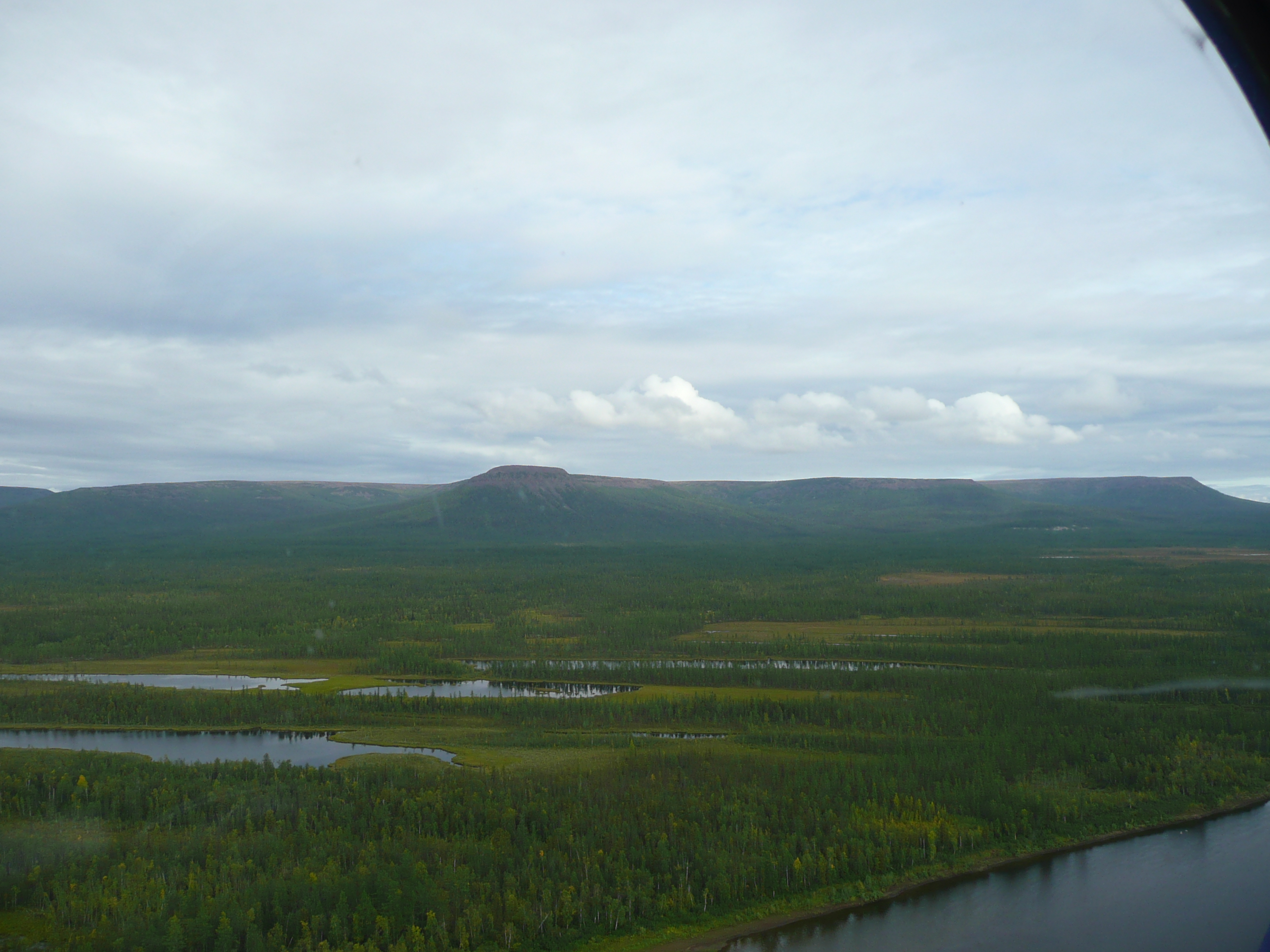
 The lower stream of Nizhnyaya Tunguska and plateau Putorana near horizon.
The navigation on the river is difficult because of a number of rifts, rapids and whirlpools. The passage of large ships and barges is possible during spring inundation and the particular years with rainy weather allows short period of navigation at the end of summer or at the start of autumn.[10] The most problematic for the safe navigation of ships is rapids "Bolshoy", which is situated in 128–130 km from the river's mouth. In 1927 the first steamship passed this rapids and it is considered to be the start of modern navigation on the river from Turukhansk to Tura. As of 2010 the shipping routes of Yenisei River Steamship Lines (Russian: Енисейское речное пароходство) includes village Kislokan in 1,155 km from estuary.[10] Timber rafting is possible throughout entire course of the river.
It was suggestions and some research in 1911 to build the canal joining Lena and Nizhnyaya Tunguska rivers in the neighbourhood of town Kirensk.[2] In the vicinity of this locality both rivers separated from each other no farther than 15 km, but here Nizhnyaya Tunguska is not navigable river and flows at the height 329.7 masl, whereas river Lena flows at altitude 245.3 masl.[11][12] In the beginning of 20th century the canal project was considered inexpedient due to its complexity and high cost.
Planned damming
The plans to dam the river existed since soviet period starting with eightieth years of 20th century. These plans were the subject of critics by ecologists. The construction also became impossible after disintegration of Soviet Union due to economic reasons. In 2005-2010 the interest to this project and the discussion of it revived to some extent. According news media the construction of the Turukhanskaya hydroelectric powerplant would begin as soon as in 2010.[13] As the precise date of works start is not known yet, it is more reliable that they can begin between 2010-2020.
After completion of this project the Lower Tunguska River will be dammed, flooding about 10,000 square kilometres (3,900 sq mi) of forest and tundra (roughly the size of Lebanon or the islands of Hawaii), some of which contains buried nuclear waste, and displacing the indigenous Evenk population. The cost of the plant is estimated at $13 billion dollars, which includes costs of electric power lines. The plant will be built and operated by RusHydro in the Krasnoyarsk region, and the electricity will be channeled to European Russia via a 3,500-kilometre (2,200 mi) system of power lines.[9][13]
Notable facts
- The colonisation history of Western Siberia by russians since 17th-18th centuries was reflected in various names which had river at different times.[14][15] At some periods it was called Troitskaya Tunguska (Russian: Trinity Tunguska), Monastyrskaya Tunguska (Russian: Monastic Tunguska) and Mangaseyan Tunguska (see Mangaseya).
- In literature river Nizhnyaya Tunguska is described in the novel (Russian: «Угрюм-река») of Vyacheslav Shishkov. This writer of the first half of 20th century had visited the river during expedition in 1911, the name Sullen river was taken from siberian song.
- Existing sources indicate that the annual average discharge of water at mouth of its tributary Severnaya is equal to 300 m³/s.[16] As this river joins Lower Tunguska downstream of hydrological station "Bolshoy Porog" it means that the known average discharge at mouth of Lower Tunguska is significantly underestimated. It must be in range 3,700-3,900 m³/s.[17]
References
- ^ a b (Russian) НИ́ЖНЯЯ ТУНГУ́СКА, Яндекс: Словарь современных географических названий
- ^ a b c (Russian) "Глава 23. Восточная Сибирь // Гидрография СССР. — 1954 г.". 1954 г.. http://www.abratsev.narod.ru/biblio/sokolov/p1ch23b.html.
- ^ (Russian) "Great Soviet Encyclopedia, 2ed, v. 43. — pp. 392-393". Москва: ПГК им.Молотова, 13.08.1956 г..
- ^ (Russian) Примечательные места Нижней Тунгуски, Осиктакан (звездочка). Эвенкия]
- ^ (Russian) Плато Путорана, Студенческий туристский клуб "Фортис"
- ^ a b Nizhnyaya Tunguska at Fakt`Bolshoy Porog, UNESCO: Water resources
- ^ Toungouska inférieure
- ^ (Russian) "Нижняя Тунгуска" в Большой Советской Энциклопедии
- ^ a b (Russian) ОВОС Эвенкийского гидроузла на реке Нижняя Тунгуска, ОАО «LenHydroProject»
- ^ a b Нижняя Тунгуска - судоходство и грузоперевозки, Енисейское пароходство
- ^ Lena at Zmeinovo, UNESCO: Water resources
- ^ Nizhnyaya Tunguska at Podvoloshino, UNESCO: Water resources
- ^ a b "Balancing Growth and Environment". The Moscow Times. July 25, 2008. http://www.themoscowtimes.com/article/600/42/369177.htm. Retrieved 2008-07-25.
- ^ (Russian) Нижняя Тунгуска Путешествия по Красноярскому краю
- ^ (Russian) «В неизведанные края. Путешествия на Север 1917 – 1930 гг», Vladimir Obruchev
- ^ (Russian) Река Северная, slovari.yandex
- ^ (Russian) "Лоцманская карта реки Н. Тунгуска от факт. Кислокан до устья. Фарватер 1964 г.". РСФСР, Министерство речного флота, Главводпуть, Енисейское бассейновое управление пути. — г. Красноярск: 1965 г.. — С. 71..
Categories:- Rivers of Irkutsk Oblast
- Rivers of Krasnoyarsk Krai

Wikimedia Foundation. 2010.