Kilmacolm railway station
- Kilmacolm railway station
Infobox UK disused station
name = Kilmacolm
other_name=
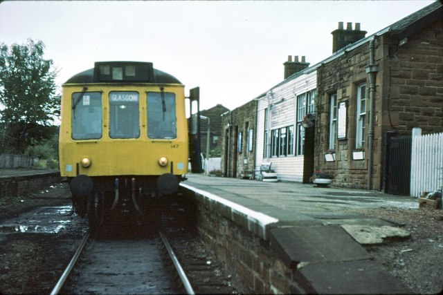
caption = Kilmacolm railway station in 1979
line = Greenock and Ayrshire Railway
manager = Glasgow and South Western Railway
locale = Kilmacolm
borough = Inverclyde
years = 23 December 1869
events = Opened as Kilmacolm G&SW
years1 = 1 December 1904
events1 = Renamed: Kilmacolm
years2 = 1907
events2 = Station largely Rebuilt
years3 = 14 February 1966
events3 = Became Terminal passenger station of Paisley Canal Line
years4 = 10 January 1983
events4 = Closure
platforms = 2
Kilmacolm railway station was a railway station serving the village of Kilmacolm, Renfrewshire, Scotland, originally as part of the Greenock and Ayrshire Railway.
History
The station opened on 23 December 1869, as Kilmacolm G&SW; however on 1 December 1904 it was renamed Kilmacolm.[Butt] The station was largely rebuilt in 1907.][Wham, Route C] ]
On 14 February 1959, stopping passenger services from Glasgow and Paisley ceased running beyond Kilmacolm; however, the St Enoch railway station, to Greenock Princes Pier Ocean Liner boat trains continued running, without stopping, through the station until 30 November 1965.[Thomas] ]
The tracks were truncated at Kilmacolm in September 1966 and it became the north western terminus of the Paisley Canal Line passenger services.
The station and the rest of the line closed on 10 January 1983.[ The former site of the station is now occupied by a tavern. ]
Notes
References
* Butt, R.V.J. (1995). "The Directory of Railway Stations". Sparkford: Patrick Stephens Ltd. ISBN 1-85260-508-1.
* Thomas, John (1971). "A regional history of the railways of Great Britain. Volume VI Scotland: The Lowlands and the Borders". Newton Abbott: David and Charles. ISBN 0-7153-5408-6.
* Wham, Alasdair (2000). "Lost Railway Lines South of Glasgow". Wigtown: G.C. Book Publishers Ltd. ISBN 1-872350-08-9.
###@@@KEYEND@@@###
Wikimedia Foundation.
2010.
Look at other dictionaries:
Elderslie railway station — Infobox UK disused station name = Elderslie caption = line = Glasgow, Paisley, Kilmarnock and Ayr Railway manager = Glasgow and South Western Railway locale = Elderslie borough = Renfrewshire latitude = 55.8387 longitude = 4.4751 gridref =… … Wikipedia
Georgetown railway station — Infobox UK disused station name = Georgetown other name= caption = line = Glasgow, Paisley and Greenock Railway manager = Caledonian Railway locale = Houston borough = Renfrewshire years = 29 March 1841 events = Opened as HoustonButt, R.V.J.… … Wikipedia
Corkerhill railway station — Corkerhill Looking east towards Dumbreck Locati … Wikipedia
Paisley Canal railway station — Infobox UK station name = Paisley Canal other name = code = PCN caption = manager = First ScotRail locale = Paisley borough = Renfrewshire latitude = 55.8403 longitude = 4.4230 pte = SPT platforms = 1 lowusage0405 = 158,340 lowusage0506 = 176,196 … Wikipedia
Bridge of Weir railway station — Infobox UK disused station name = Bridge of Weir other name= caption = original = Bridge of Weir Railway pregroup = Glasgow and South Western Railway postgroup = London Midland and Scottish Railway locale = Bridge of Weir borough = Renfrewshire… … Wikipedia
Kilmacolm — infobox UK place country = Scotland official name= Kilmacolm gaelic name= Cille MhaolChaluim scots name= os grid reference= NS365695 latitude=55.89079 longitude= 4.61601 map type= Scotland population= c. 4500 (village) c.7000 (parish) [… … Wikipedia
Greenock and Ayrshire Railway — MetaSidebar|19%|#949699|right|Greenock and Ayrshire Railway|(south east to north west) Bridge of WeirKilmacolmPort Glasgow (Upper)Port Glasgow (Inch Green) Lynedoch Princes PierThe Greenock and Ayrshire Railway ran from Greenock, Scotland to… … Wikipedia
Glasgow and South Western Railway — Infobox SG rail railroad name = Glasgow and South Western Railway logo filename = GSWR logo.png logo size = system map caption = map size = marks = image size = image caption = locale = Scotland start year = 1850 end year = 1923 predecessor line … Wikipedia
Duchal Moor Railway — The old Duchal Moor Railway grouse railway lies in the Duchal Moor and Muirshiel Hills within the Clyde Muirshiel Regional Park, 3 miles (5 km) west southwest of Kilmacolm in Scotland … Wikipedia
Houston, Renfrewshire — infobox UK place country = Scotland official name= Houston gaelic name= scots name= os grid reference= NS404667 map type= Scotland latitude=55.86697 longitude= 4.55207 population= 6610 (1991 census) unitary scotland=Renfrewshire lieutenancy… … Wikipedia