Mount Loura

Mount Loura
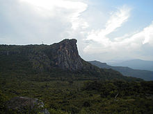
The "Dame de Maali".

Mount Loura, alt. 1515 m (Fello Luura in the Pular language) is the northernmost point and highest peak in the Fouta Djallon in northern Guinea. It is 7 km from the prefecture of Maali (also Mali-ville or Mali-Centre). It is part of a complex of mountains called the Massif de Tamgue, which rises to steep cliffs on three sides, and provides views into Senegal and Mali. Its most interesting feature, the rocky profile of an old woman (referred to as the "Dame de Maali" or "Lady of Maali"), can be seen from the nearby village of Dongol Luura.[citation needed]

Lady of Maali

Coordinates: 12°04′17″N 12°05′04″W / 12.0715°N 12.0844°W / 12.0715; -12.0844


Wikimedia Foundation. 2010.

Игры ⚽ Нужен реферат?

Look at other dictionaries:

  • Mali, Guinea — Mali   Sub prefecture and town   Mount Loura …   Wikipedia

  • Guinea — Guinean, adj., n. /gin ee/, n. 1. a coastal region in W Africa, extending from the Gambia River to the Gabon estuary. 2. Formerly, French Guinea. an independent republic in W Africa, on the Atlantic coast. 7,405,375; ab. 96,900 sq. mi. (251,000… …   Universalium

  • Fouta Djallon — is a highland region in the center of Guinea, West Africa. The indigenous name is Fuuta Jaloo (sometimes spelled Fuuta Jalon ; Fouta Djallon is a French spelling; in English it is sometimes also written Futa Jalon ). The origin of the name is… …   Wikipedia

  • Fouta Djallon — ▪ region, Guinea also spelled  Futa Jallon,         mountainous region of west central Guinea. Consisting of a series of stepped sandstone plateaus with many picturesque trenches and gorges, the region serves as the watershed for some of western… …   Universalium

Share the article and excerpts

Direct link
Do a right-click on the link above
and select “Copy Link”