- Doe River
-
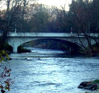
Doe River River  Doe River flowing from Roan Mountain to Elizabethton, Tennessee
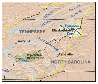
Country USA State Tennessee Region Northeast Tennessee District Carter County Municipality Elizabethton Tributaries - left McCathern Spring City Hampton, Tennessee Source Roan Mountain (Roan Highlands) - location Roan Mountain, Tennessee, Northeast Tennessee, USA Mouth Watauga River - location Elizabethton, Tennessee, Norheast Tennessee, USA The Doe River is a naturally flowing river in northeast Tennessee that forms in Carter County near the North Carolina line, just south of Roan Mountain State Park.
Contents
Hydrography
The Doe River flows from the northern slopes of Roan Mountain, through Roan Mountain State Park and the center of Roan Mountain, Tennessee, then continues to flow west and is paralleled by U.S. Route 19E. The stream then flows to the east of Fork Mountain; while the Little Doe River flows by Fork Mountain to the west.
Hampton and Valley Forge
Pushing through a mountain gap just north of Hampton, Tennessee, the volume of the Doe River is increased by the waters flowing from McCathern Spring. Below the confluence of both the Doe River and the Little Doe River at Hampton, the Doe River travels roughly in a northern direction through the Valley Forge community, and is rejoined by U.S. Route 19E outside of Elizabethton.
Elizabethton
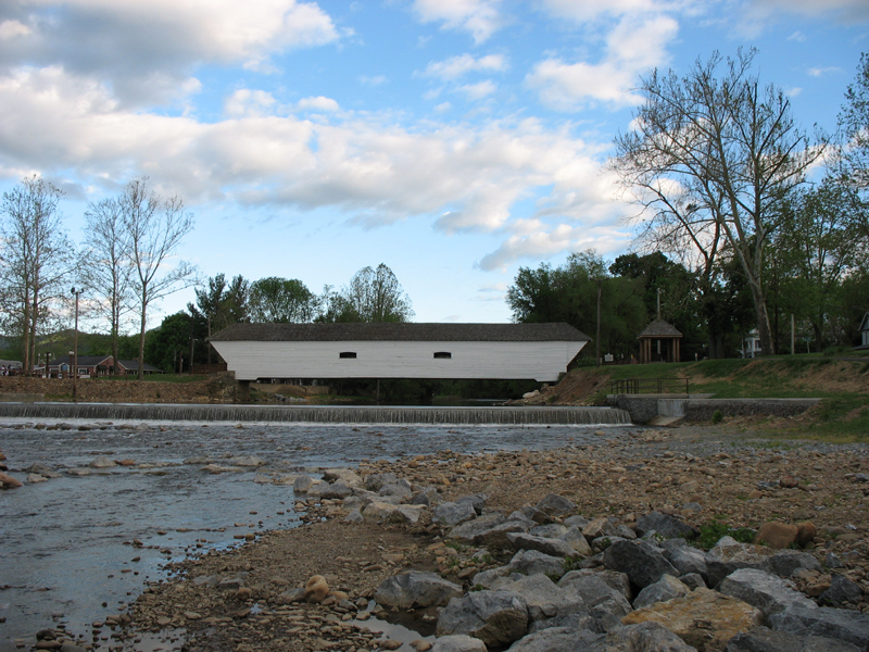
Elizabethton Covered Bridge
Main article: Elizabethton Covered BridgeFlowing parallel with U.S. Highway 19-E, the Doe River flows underneath two 19-E bridges at the East Side community before heading in a northwest angle toward the Elizabethton downtown business district. The Elizabethton Covered Bridge is located in downtown Elizabethton, the county seat of Carter County. Connecting 3rd Street and Hattie Avenue, the historic 1882 covered bridge spans the Doe River is adjacent to a significant city city park and county government area s.
While allowing for pedestrian and bicycle transit over the Doe River, the Elizabethton Covered Bridge is now closed to motor vehicle traffic.
The Doe River spills over a weir dam immediately downstream of the historic covered bridge,and then flows underneath two 1928 concrete arch bridges inside of Elizabethton. The first concrete arch bridge is the Elk Avenue Bridge in downtown Elizabethton, and the second concrete arch bridge downstream of the Elizabethton Covered Bridge is locally known as the Broad Street Bridge. The Broad Street Bridge carries traffic along Tennessee State Route 67 .
The confluence of the Doe River and the Watauga River is approximately fifteen minutes downstream from the Broad Street Bridge.
Whitewater kayaking and river tubing
Most of the Doe River section running between the Valley Forge put-in (LAT 36.310833 LONG -82.193055) and the take-out just before the Elizabethton confluence is classified on the International Scale of River Difficulty as Class/Grade I; however there are several brief segments of the Valley Forge-Charity Hill-East Side run that should be approached as Class/Grade II. It takes approximately three hours to float down the Doe River on inner tubes from the Valley Forge put-in to the take-out near the confluence of the Doe River into the Watauga River.
All river tubes and kayaks must portage around the weir dam that is located immediately downstream of the covered bridge in downtown Elizabethton.
There is a Class III/IV section of whitewater referred to as the Doe Gorge that begins at the bridge over the river on Bear Cage Rd. and ends at the take-out at Hampton High School. This sections drops between 100 and 160 feet per mile. The gorge is for advanced paddlers only.
Influence of weather
Unlike the Tennessee Valley Authority (TVA) regulated flow of the Watauga River, the water level of the Doe River often fluctuates with changes in rain fall or drought. Another significant difference between the two Carter County rivers is the variation of water temperatures: while the year round water temperature of the Watauga River is approximately 52-53 degrees Fahrenheit, the water temperature of the Doe River will vary along with the ambient air temperature. The Doe River is generally very comfortable for kayaking and river tubing during the summer months.
The Doe River valley is infrequently subject to severe flooding. The Doe River drains from a mountainous region that can be subject to seasonal heavy rains (May-early June) and snow melts, and the Doe River stream course is in many parts quite steep, allowing water levels to rise rapidly along the river banks. The last severe recent flooding of the Doe River occurred overnight from January 7 through January 8, 1998, with the sudden storms bringing down seven inches (178 mm) of rain in twelve hours and causing the deaths of seven people (including Kingsport rescue worker Carles "Junior" Godsey after his rescue boat overturned in the Doe River flood waters) in the Hampton area. The 1998 Doe River flood created approximately $20 million in Carter County property damages.[1]
Climate of Doe River in Elizabethton, Tennessee Month Jan Feb Mar Apr May Jun Jul Aug Sep Oct Nov Dec Annual Avg °F(°C) 34.0°F 1.1°C 37.4°F 3.0°C 47.2°F 8.4°C 55.2°F 12.9°C 63.4°F 17.4°C 71.1°F 21.7°C 74.4°F 23.6°C 73.6°F 23.1°C 67.9°F 19.9°C 56.7°F 13.7°C 47.0°F 8.3°C 38.2°F 3.4°C 55.5°F 13.1°C Avg high °F(°C) 43.7°F 6.5°C 48.0°F 8.9°C 58.9°F 14.9°C 67.4°F 19.7°C 75.2°F 24.0°C 82.2°F 27.9°C 84.6°F 29.2°C 84.1°F 28.9°C 79.1°F 26.2°C 69.1°F 20.6°C 58.2°F 14.6°C 48.1°F 8.9°C 66.6°F 19.2°C Avg low °F(°C) 24.3°F
-4.3°C26.8°F
-2.9°C35.4°F 1.9°C 43.0°F 6.1°C 51.6°F 10.9°C 59.9°F 15.5°C 64.1°F 17.8°C 63.1°F 17.3°C 56.6°F 13.7°C 44.2°F 6.8°C 35.9°F 2.2°C 28.2°F -2.1°C 44.4°F 6.9°C Rain (inches) 3.2 in. 3.4 in. 3.7 in. 3.3 in. 3.8 in. 3.5 in. 4.3 in. 3.2 in. 3.3 in. 2.6 in. 2.9 in. 3.4 in. 40.7 in. Snow (inches) 5.2 in. 4.2 in. 2.3 in. 0.4 in. 0.05 in. 0.05 in. 0.0 in. 0.0 in. 0.05 in. 0.0 in. 0.9 in. 2.6 in. 15.6 in. Sources for Doe River in Elizabethton (Bristol-Johnson City, Tennessee) climate statistics: climate-zone.com'[2] References
Categories:- Geography of Carter County, Tennessee
- Rivers of Tennessee
- Rivers used for whitewater recreation
-
Wikimedia Foundation. 2010.